« Back to Northern Lights Rivers
Missisquoi River at Swanton
Critical Stages
6' - Action
8' - Flood
9' - Moderate
Major
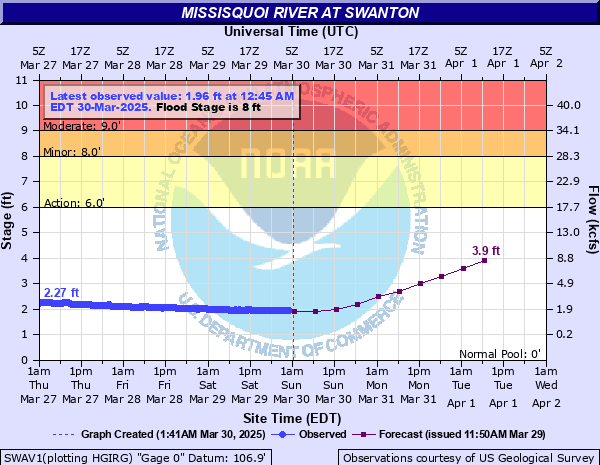
Latest Observation
Updated: 1:45 AM EST 12/15/25
Status: No Flooding
Stage: 1.4 ft
Flow: 0.703 kcfs
Forecast
| Time | Stage (ft) | Flow (kcfs) |
|---|---|---|
| 7 AM 12/15 | 1.4 | 0.703 |
| 1 PM 12/15 | 1.4 | 0.703 |
| 7 PM 12/15 | 1.4 | 0.703 |
| 1 AM 12/16 | 1.4 | 0.703 |
| 7 AM 12/16 | 1.3 | 0.561 |
| 1 PM 12/16 | 1.3 | 0.561 |
| 7 PM 12/16 | 1.3 | 0.561 |
| 1 AM 12/17 | 1.3 | 0.561 |
| 7 AM 12/17 | 1.3 | 0.561 |
| Time | Stage (ft) | Flow (kcfs) |
|---|---|---|
| 2:45 AM 12/15 | 1.39 | 0.688 |
| 2:30 AM 12/15 | 1.39 | 0.688 |
| 2:15 AM 12/15 | 1.39 | 0.688 |
| 2:00 AM 12/15 | 1.4 | 0.703 |
| 1:45 AM 12/15 | 1.4 | 0.703 |
| 1:30 AM 12/15 | 1.39 | 0.688 |
| 1:15 AM 12/15 | 1.4 | 0.703 |
| 1:00 AM 12/15 | 1.4 | 0.703 |
| 12:45 AM 12/15 | 1.4 | 0.703 |
| 12:30 AM 12/15 | 1.4 | 0.703 |
| 12:15 AM 12/15 | 1.4 | 0.703 |
| 12:00 AM 12/15 | 1.4 | 0.703 |
| 11:45 PM 12/14 | 1.41 | 0.718 |
| 11:30 PM 12/14 | 1.4 | 0.703 |
| 11:15 PM 12/14 | 1.41 | 0.718 |
| 11:00 PM 12/14 | 1.4 | 0.703 |
| 10:45 PM 12/14 | 1.41 | 0.718 |
| 10:30 PM 12/14 | 1.41 | 0.718 |
| 10:15 PM 12/14 | 1.41 | 0.718 |
| 10:00 PM 12/14 | 1.41 | 0.718 |
| 9:45 PM 12/14 | 1.41 | 0.718 |
| 9:30 PM 12/14 | 1.41 | 0.718 |
| 9:15 PM 12/14 | 1.41 | 0.718 |
| 9:00 PM 12/14 | 1.41 | 0.718 |
| 8:45 PM 12/14 | 1.41 | 0.718 |
| 8:30 PM 12/14 | 1.41 | 0.718 |
| 8:15 PM 12/14 | 1.41 | 0.718 |
| 8:00 PM 12/14 | 1.41 | 0.718 |
| 7:45 PM 12/14 | 1.41 | 0.718 |
| 7:30 PM 12/14 | 1.42 | 0.733 |
9' -
Water will cover Foundry Street and Marble Mill Park in Swanton Village. Downstream in West Swanton, Route 78 will be covered, and residences along the river will flood. Access roads and boat landings in the Missisquoi Wildlife Management area will be inundated. Upstream of Swanton, water will cover Waugh Farm Road. Further upstream near East Highgate, water will approach Route 78.
8' -
Water will cover Foundry Street in Swanton Village, and enter Marble Mill Park. Water will cover one lane of Route 78 downstream in West Swanton, surround seasonal camps, and enter the back yards of homes along Route 78. In the Missisquoi Wildlife Management area, Louies Landing will flood along with local access roads. Upstream of Swanton, Waugh Farm Road will become inundated. There will be widespread lowland and field flooding.
| Date | Stage (ft) |
|---|---|
| Jan 14, 2018 | 13.14 |
| Jan 20, 1996 | 9.5 |
| Nov 2, 2019 | 9.49 |
| Jan 9, 1998 | 8.64 |
| Jun 12, 2002 | 8.46 |
| May 20, 2006 | 8.24 |
| Jul 15, 1997 | 8.05 |
| Apr 16, 2014 | 7.99 |
| Apr 29, 2011 | 7.51 |
| Mar 18, 1990 | 7.4 |
| Apr 16, 1994 | 7.16 |
| Mar 5, 1991 | 6.98 |
| Jul 11, 2023 | 6.97 |
| Feb 29, 2000 | 6.69 |
| Feb 29, 2000 | 6.69 |
| Nov 20, 2003 | 6.57 |
| Apr 23, 1992 | 6.48 |
| Oct 18, 2005 | 6.07 |
| May 11, 2000 | 5.81 |
| Mar 30, 2003 | 5.67 |
Data provided by the National Weather Service.