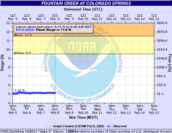
Fountain Creek at Colorado Springs
Critical Stages
9.5' - Action
11.5' - Flood
16' - Moderate
18' - Major
Latest Observation
Updated: 1:45 PM MST 12/6/25
Status: No Flooding
Stage: 5.26 ft
Flow: 0.0618 kcfs
Forecast
Forecast not available for this location.
| Time | Stage (ft) | Flow (kcfs) |
|---|---|---|
| 1:45 PM 12/6 | 5.26 | 0.0618 |
| 1:30 PM 12/6 | 5.26 | 0.0618 |
| 1:15 PM 12/6 | 5.25 | 0.0603 |
| 1:00 PM 12/6 | 5.25 | 0.0603 |
| 12:45 PM 12/6 | 5.22 | 0.0559 |
| 12:30 PM 12/6 | 5.22 | 0.0559 |
| 12:15 PM 12/6 | 5.22 | 0.0559 |
| 12:00 PM 12/6 | 5.23 | 0.0573 |
| 11:45 AM 12/6 | 5.27 | 0.0634 |
| 11:30 AM 12/6 | 5.27 | 0.0634 |
| 11:15 AM 12/6 | 5.26 | 0.0618 |
| 11:00 AM 12/6 | 5.23 | 0.0573 |
| 10:45 AM 12/6 | 5.17 | 0.0492 |
| 10:30 AM 12/6 | 5.18 | 0.0505 |
| 10:15 AM 12/6 | 5.17 | 0.0492 |
| 10:00 AM 12/6 | 5.18 | 0.0505 |
| 9:45 AM 12/6 | 5.15 | 0.0467 |
| 9:30 AM 12/6 | 5.15 | 0.0467 |
| 9:15 AM 12/6 | 5.15 | 0.0467 |
| 9:00 AM 12/6 | 5.14 | 0.0456 |
| 8:45 AM 12/6 | 5.13 | 0.0444 |
| 8:30 AM 12/6 | 5.14 | 0.0456 |
| 8:15 AM 12/6 | 5.13 | 0.0444 |
| 8:00 AM 12/6 | 5.13 | 0.0444 |
| 7:45 AM 12/6 | 5.14 | 0.0456 |
| 7:30 AM 12/6 | 5.15 | 0.0467 |
| 7:15 AM 12/6 | 5.14 | 0.0456 |
| 7:00 AM 12/6 | 5.15 | 0.0467 |
| 6:45 AM 12/6 | 5.15 | 0.0467 |
| 6:30 AM 12/6 | 5.14 | 0.0456 |
28' -
Flood waters inundate Circle Drive Mobile Home Park near South Circle Drive.
23' -
Flood waters flow over South Nevada Avenue in downtown Colorado Springs. Waters threaten I-25 on-ramp.
21' -
Flood waters flow into Dorchester Park near South Nevada Avenue.
18' -
Water reaches the base of the South Nevada Avenue Bridge.
17' -
Flood waters threaten homes south of Security-Widefield at the end of Leigh Lane in the residential development along Southmoor Drive.
15.5' -
Water flows over the Front Range Trail near Janitell Road.
15' -
Flood waters reach the base of the South Tejon Street Bridge.
14' -
Flood waters threaten homes in Stratmoor northwest of Security-Widefield.
13' -
Minor flooding of lowlands along the creek occurs.
12' -
Communities below and near the Nevada Avenue bridge are affected.
11.5' -
Flood Stage. The river is bankfull. Communities along creek are affected.
9.5' -
Action Stage. Water flows over the Front Range Trail under the South Nevada Avenue Bridge. Communities along creek may be affected.
| Date | Stage (ft) |
|---|---|
| Jul 20, 2019 | 12.1 |
Data provided by the National Weather Service.