Chattahoochee River at Buford Dam near Buford
Critical Stages
8' - Action
12' - Flood
Moderate
Major
Latest Observation
Updated: 5:45 PM EST 12/5/25
Status: No Flooding
Stage: -0.54 ft
Flow: -999 kcfs
Forecast
Forecast not available for this location.
| Time | Stage (ft) | Flow (kcfs) |
|---|---|---|
| 6:00 PM 12/5 | -0.54 | -999 |
| 5:45 PM 12/5 | -0.54 | -999 |
| 5:30 PM 12/5 | -0.54 | -999 |
| 5:15 PM 12/5 | -0.54 | -999 |
| 5:00 PM 12/5 | -0.54 | -999 |
| 4:45 PM 12/5 | -0.54 | -999 |
| 4:30 PM 12/5 | -0.54 | -999 |
| 4:15 PM 12/5 | -0.54 | -999 |
| 4:00 PM 12/5 | -0.54 | -999 |
| 3:45 PM 12/5 | -0.54 | -999 |
| 3:30 PM 12/5 | -0.54 | -999 |
| 3:15 PM 12/5 | -0.54 | -999 |
| 3:00 PM 12/5 | -0.54 | -999 |
| 2:45 PM 12/5 | -0.54 | -999 |
| 2:30 PM 12/5 | -0.54 | -999 |
| 2:15 PM 12/5 | -0.54 | -999 |
| 2:00 PM 12/5 | -0.54 | -999 |
| 1:45 PM 12/5 | -0.54 | -999 |
| 1:30 PM 12/5 | -0.54 | -999 |
| 1:15 PM 12/5 | -0.54 | -999 |
| 1:00 PM 12/5 | -0.54 | -999 |
| 12:45 PM 12/5 | -0.54 | -999 |
| 12:30 PM 12/5 | -0.54 | -999 |
| 12:15 PM 12/5 | -0.54 | -999 |
| 12:00 PM 12/5 | -0.54 | -999 |
| 11:45 AM 12/5 | -0.54 | -999 |
| 11:30 AM 12/5 | -0.54 | -999 |
| 11:15 AM 12/5 | -0.54 | -999 |
| 11:00 AM 12/5 | -0.54 | -999 |
| 10:45 AM 12/5 | -0.54 | -999 |
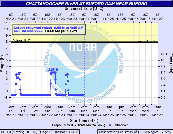
12' -
Flood stage is reached. Minor flooding begins on the river just downstream from Buford Dam. This will primarily affect the woodlands in the Chattahoochee River National Recreation Area. Portions of Little Mill Road leading to a park near the dam will begin to flood.
10' -
Bankfull conditions continue on the river just downstream from Buford Dam. Some low lying areas near the banks will begin to flood in the Chattahoochee River National Recreation Area.
8' -
Bankfull conditions occur on the river just downstream from Buford Dam.
| Date | Stage (ft) |
|---|---|
| Oct 22, 1971 | 7.88 |
| Oct 10, 1972 | 7.76 |
| Nov 2, 1978 | 7.41 |
| Jun 29, 1976 | 7.3 |
| Sep 4, 1975 | 7.3 |
Data provided by the National Weather Service.