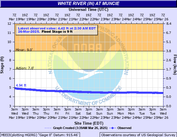
White River (IN) at Muncie
Critical Stages
7' - Action
9' - Flood
12' - Moderate
15' - Major
Latest Observation
Updated: 12:30 AM EST 12/6/25
Status: No Flooding
Stage: 4.07 ft
Flow: 0.0205 kcfs
Forecast
Forecast not available for this location.
| Time | Stage (ft) | Flow (kcfs) |
|---|---|---|
| 12:30 AM 12/6 | 4.07 | 0.0205 |
| 12:15 AM 12/6 | 4.07 | 0.0205 |
| 12:00 AM 12/6 | 4.07 | 0.0205 |
| 11:45 PM 12/5 | 4.07 | 0.0205 |
| 11:30 PM 12/5 | 4.07 | 0.0205 |
| 11:15 PM 12/5 | 4.07 | 0.0205 |
| 11:00 PM 12/5 | 4.08 | 0.022 |
| 10:45 PM 12/5 | 4.07 | 0.0205 |
| 10:30 PM 12/5 | 4.07 | 0.0205 |
| 10:15 PM 12/5 | 4.07 | 0.0205 |
| 10:00 PM 12/5 | 4.07 | 0.0205 |
| 9:45 PM 12/5 | 4.07 | 0.0205 |
| 9:30 PM 12/5 | 4.06 | 0.0192 |
| 9:15 PM 12/5 | 4.07 | 0.0205 |
| 9:00 PM 12/5 | 4.06 | 0.0192 |
| 8:45 PM 12/5 | 4.06 | 0.0192 |
| 8:30 PM 12/5 | 4.05 | 0.0179 |
| 8:15 PM 12/5 | 4.05 | 0.0179 |
| 8:00 PM 12/5 | 4.05 | 0.0179 |
| 7:45 PM 12/5 | 4.04 | 0.0167 |
| 7:30 PM 12/5 | 4.04 | 0.0167 |
| 7:15 PM 12/5 | 4.03 | 0.0156 |
| 7:00 PM 12/5 | 4.03 | 0.0156 |
| 6:45 PM 12/5 | 4.02 | 0.0145 |
| 6:30 PM 12/5 | 4.02 | 0.0145 |
| 6:15 PM 12/5 | 4.01 | 0.0136 |
| 6:00 PM 12/5 | 4.01 | 0.0136 |
| 5:45 PM 12/5 | 4.02 | 0.0145 |
| 5:30 PM 12/5 | 4.01 | 0.0136 |
| 5:15 PM 12/5 | 4.01 | 0.0136 |
22.3' -
Disastrous flooding in rural Delaware County and major flooding in Muncie if flood protection fails. Maximum recordable stage as of 2012.
21' -
Water is at critical level for main levee system in city of Muncie. This is an unbelievable flood with serious damage for Muncie and Delaware County.
17.5' -
Record flooding is in progress for rural areas of Delaware County along the White River. Many rural roads impassable with flooding of homes in flood plain areas of the White River. Water is at the level of approximate record flood flow. Major modifications to White River at Muncie from 1940 to 1950 has lowered the March 1913 flood level in the city of Muncie.
16' -
Erection of flood gate at abandoned municipal swimming pool behind 1706 E. Main Street is necessary. The flood gate protects Muncie's downtown business district. October 2002...this site had a mobile home residence and a chain link gate in the opening. The resident lived on the riverward side of the protection. The mailbox had 1700 on it and the road sign said East Washington.
15' -
Evacuations may be necessary of residents east of Burlington Street and south of 12th Street. State Road 32 east of Muncie floods.
14' -
Area roads flood. Residences in southeast sections of Muncie flood. Some evacuations may be necessary.
13.5' -
Erection of closure at the former Indiana Wire and Steel plant on Bunch Blvd just north of SR 32. The plant grounds lie abandoned in 2007. During Summer of 2009 the former plant was being demolished.
12.5' -
Sandbagging is necessary to protect the Muncie Water Treatment Plant.
12' -
Flooding begins in four to five block area of southeast Muncie near 16th St and S Burlington Dr and in Smithfield. County roads and farmland flood. Water level reaches critical stage for levees protecting the Muncie Water Treatment Plant.
10' -
Riverview and McCulloch Parks, including park roads, begin to flood. Backyards of houses in Yorktown along Buck Creek begin to flood. Backyards of houses and outbuildings along White River in Muncie begin to flood.
9.5' -
Flooding of lowlands across Delaware County outside of the city of Muncie. Only high levels in the city of Muncie.
9' -
Some farmlands and county roads flood. Small park near Daleville floods.
8' -
Lowland flooding begins in city parks and residential backyards.
6' -
River is bankfull.
| Date | Stage (ft) |
|---|---|
| Mar 25, 1913 | 22.6 |
| Jan 15, 1937 | 21.07 |
| May 14, 1933 | 20.61 |
| Mar 20, 1927 | 20 |
| Jun 8, 1924 | 19.7 |
| Mar 1, 1904 | 19.6 |
| Sep 9, 1926 | 18.3 |
| Apr 16, 1939 | 17.67 |
| Jan 22, 1937 | 17.67 |
| Mar 29, 1924 | 17.5 |
| May 19, 1927 | 17.4 |
| Feb 26, 1929 | 17.2 |
| Sep 5, 1926 | 17 |
| Jan 19, 1929 | 17 |
| Apr 7, 1938 | 16.56 |
| Dec 18, 1937 | 16.56 |
| Nov 13, 1925 | 16.2 |
| Jun 26, 1928 | 16.2 |
| Jun 26, 1938 | 16 |
| Sep 11, 1927 | 16 |
Data provided by the National Weather Service.