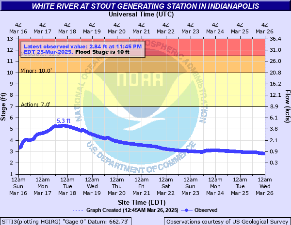
White River (IN) at Stout Power Plant
Critical Stages
7' - Action
10' - Flood
11.5' - Moderate
Major
Latest Observation
Updated: 12:45 AM EST 12/6/25
Status: No Flooding
Stage: 2.27 ft
Flow: 0.662 kcfs
Forecast
Forecast not available for this location.
| Time | Stage (ft) | Flow (kcfs) |
|---|---|---|
| 12:45 AM 12/6 | 2.27 | 0.662 |
| 12:30 AM 12/6 | 2.27 | 0.662 |
| 12:15 AM 12/6 | 2.28 | 0.669 |
| 12:00 AM 12/6 | 2.27 | 0.662 |
| 11:45 PM 12/5 | 2.27 | 0.662 |
| 11:30 PM 12/5 | 2.27 | 0.662 |
| 11:15 PM 12/5 | 2.27 | 0.662 |
| 11:00 PM 12/5 | 2.27 | 0.662 |
| 10:45 PM 12/5 | 2.27 | 0.662 |
| 10:30 PM 12/5 | 2.27 | 0.662 |
| 10:15 PM 12/5 | 2.27 | 0.662 |
| 10:00 PM 12/5 | 2.27 | 0.662 |
| 9:45 PM 12/5 | 2.27 | 0.662 |
| 9:30 PM 12/5 | 2.27 | 0.662 |
| 9:15 PM 12/5 | 2.27 | 0.662 |
| 9:00 PM 12/5 | 2.26 | 0.655 |
| 8:45 PM 12/5 | 2.27 | 0.662 |
| 8:30 PM 12/5 | 2.27 | 0.662 |
| 8:15 PM 12/5 | 2.27 | 0.662 |
| 8:00 PM 12/5 | 2.27 | 0.662 |
| 7:45 PM 12/5 | 2.27 | 0.662 |
| 7:30 PM 12/5 | 2.26 | 0.655 |
| 7:15 PM 12/5 | 2.27 | 0.662 |
| 7:00 PM 12/5 | 2.26 | 0.655 |
| 6:45 PM 12/5 | 2.26 | 0.655 |
| 6:30 PM 12/5 | 2.27 | 0.662 |
| 6:15 PM 12/5 | 2.26 | 0.655 |
| 6:00 PM 12/5 | 2.27 | 0.662 |
| 5:45 PM 12/5 | 2.27 | 0.662 |
| 5:30 PM 12/5 | 2.26 | 0.655 |
11.5' -
Centenary Road in Morgan County south of SR 144 floods between Watson and Kitchen Roads.
| Date | Stage (ft) |
|---|---|
| Mar 26, 1913 | 28.9 |
| Sep 1, 2003 | 15.42 |
| Apr 19, 2013 | 13.27 |
| Nov 17, 1993 | 13.22 |
| May 13, 2002 | 12.24 |
| May 5, 2017 | 12.03 |
| Mar 1, 2011 | 11.98 |
| Jun 15, 1998 | 11.68 |
| Jan 23, 1999 | 11.63 |
| Jan 13, 2013 | 11.5 |
| Nov 15, 1993 | 11.3 |
| Apr 6, 2025 | 11.1 |
| Feb 7, 2008 | 10.82 |
| Apr 4, 2018 | 10.69 |
| Nov 14, 1992 | 10.5 |
| Dec 23, 2013 | 10.44 |
| Apr 4, 2014 | 10.41 |
| Feb 28, 1997 | 10.36 |
| Feb 27, 1997 | 10.36 |
| Jun 23, 2010 | 10.35 |
Data provided by the National Weather Service.