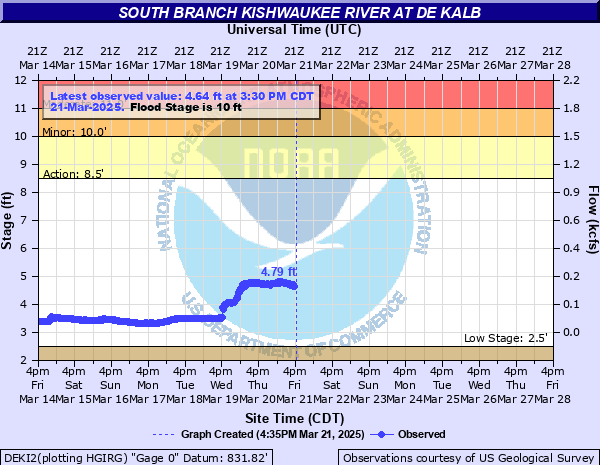
South Branch Kishwaukee River at De Kalb
Critical Stages
8.5' - Action
10' - Flood
11' - Moderate
12.5' - Major
Latest Observation
Updated: 10:30 AM CST 12/6/25
Status: No Flooding
Stage: 2.62 ft
Flow: 0.0011 kcfs
Forecast
Forecast not available for this location.
| Time | Stage (ft) | Flow (kcfs) |
|---|---|---|
| 10:30 AM 12/6 | 2.62 | 0.0011 |
| 10:15 AM 12/6 | 2.63 | 0.0012 |
| 10:00 AM 12/6 | 2.63 | 0.0012 |
| 9:45 AM 12/6 | 2.62 | 0.0011 |
| 9:30 AM 12/6 | 2.63 | 0.0012 |
| 9:15 AM 12/6 | 2.62 | 0.0011 |
| 9:00 AM 12/6 | 2.62 | 0.0011 |
| 8:45 AM 12/6 | 2.62 | 0.0011 |
| 8:30 AM 12/6 | 2.63 | 0.0012 |
| 8:15 AM 12/6 | 2.63 | 0.0012 |
| 8:00 AM 12/6 | 2.62 | 0.0011 |
| 7:45 AM 12/6 | 2.63 | 0.0012 |
| 7:30 AM 12/6 | 2.63 | 0.0012 |
| 7:15 AM 12/6 | 2.63 | 0.0012 |
| 7:00 AM 12/6 | 2.62 | 0.0011 |
| 6:45 AM 12/6 | 2.63 | 0.0012 |
| 6:30 AM 12/6 | 2.63 | 0.0012 |
| 6:15 AM 12/6 | 2.63 | 0.0012 |
| 6:00 AM 12/6 | 2.63 | 0.0012 |
| 5:45 AM 12/6 | 2.63 | 0.0012 |
| 5:30 AM 12/6 | 2.63 | 0.0012 |
| 5:15 AM 12/6 | 2.62 | 0.0011 |
| 5:00 AM 12/6 | 2.62 | 0.0011 |
| 4:45 AM 12/6 | 2.62 | 0.0011 |
| 4:30 AM 12/6 | 2.63 | 0.0012 |
| 4:15 AM 12/6 | 2.63 | 0.0012 |
| 4:00 AM 12/6 | 2.63 | 0.0012 |
| 3:45 AM 12/6 | 2.63 | 0.0012 |
| 3:30 AM 12/6 | 2.63 | 0.0012 |
| 3:15 AM 12/6 | 2.63 | 0.0012 |
17.5' -
Bethany Road threatened.
16' -
Multiple structures threatened at Northern Illinois University. DeKalb Sanitary District property threatened.
15.5' -
Coltonville Road threatened north of DeKalb. Park Avenue (IL-72) and Madison Avenue may be threatened in Genoa.
15' -
Annie Glidden Road threatened near Taylor Street.
14.5' -
Roadways and structures threatened at Edgebrook Mobile Home Park. First Street threatened.
14' -
IL-64 is threatened west of Sycamore.
13.5' -
Flood waters overtop levee north of Hillcrest Street in DeKalb.
13' -
Water overtops the levee at the east lagoon at Northern Illinois University. Castle Drive and Lucinda Avenue threatened.
12.5' -
A few structures threatened at Northern Illinois University.
12' -
Low-lying portions of River Heights Golf Course inundated.
11' -
Clifford Drive is threatened near Prairie Park in DeKalb. Creek Court threatened south of DeKalb.
10.5' -
Residences threatened near the river on Taylor Street. Fairview Drive is threatened near the river south of DeKalb.
9' -
Taylor Street is threatened. Low-lying portions of Lions Park inundated in DeKalb.
8.5' -
Water overtops low-lying banks in DeKalb.
7.5' -
Gurler Road threatened southwest of DeKalb.
6' -
DeKalb Nature Trail is threatened near and south of Lincoln Highway.
| Date | Stage (ft) |
|---|---|
| Jul 2, 1983 | 15.8 |
| Aug 24, 2007 | 15.34 |
| Oct 1, 1954 | 15.24 |
| Oct 11, 1954 | 15.24 |
| Jul 18, 1996 | 12.97 |
| Feb 21, 1997 | 12.64 |
| Jun 12, 1929 | 12.33 |
| May 24, 1927 | 12.28 |
| Sep 9, 1980 | 11.32 |
| Sep 14, 2008 | 11.28 |
| May 15, 2020 | 11.25 |
| Aug 27, 1987 | 10.97 |
| Apr 18, 2013 | 10.84 |
| Feb 25, 1926 | 10.78 |
| May 12, 2016 | 10.7 |
| May 31, 2004 | 10.62 |
| Mar 3, 1985 | 9.91 |
| Jun 5, 2002 | 9.86 |
| Jul 2, 1933 | 9.72 |
| Jun 14, 1981 | 9.61 |
Data provided by the National Weather Service.