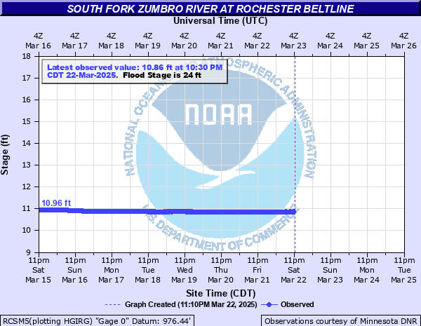
South Fork Zumbro River at Rochester Beltline
Critical Stages
18' - Action
24' - Flood
26' - Moderate
29' - Major
Latest Observation
Updated: 10:30 AM CST 12/15/25
Status: No Flooding
Stage: 10.48 ft
Flow: 0.0001 kcfs
Forecast
Forecast not available for this location.
| Time | Stage (ft) | Flow (kcfs) |
|---|---|---|
| 11:30 AM 12/15 | 10.48 | 0.0001 |
| 11:15 AM 12/15 | 10.5 | 0.001 |
| 11:00 AM 12/15 | 10.5 | 0.001 |
| 10:45 AM 12/15 | 10.43 | 0 |
| 10:30 AM 12/15 | 10.48 | 0.0001 |
| 10:15 AM 12/15 | 10.46 | 0 |
| 10:00 AM 12/15 | 10.44 | 0 |
| 9:45 AM 12/15 | 10.49 | 0.0003 |
| 9:30 AM 12/15 | 10.49 | 0.0003 |
| 9:15 AM 12/15 | 10.49 | 0.0003 |
| 9:00 AM 12/15 | 10.49 | 0.0003 |
| 8:45 AM 12/15 | 10.49 | 0.0003 |
| 8:30 AM 12/15 | 10.5 | 0.001 |
| 8:15 AM 12/15 | 10.49 | 0.0003 |
| 8:00 AM 12/15 | 10.45 | 0 |
| 7:45 AM 12/15 | 10.45 | 0 |
| 7:30 AM 12/15 | 10.5 | 0.001 |
| 7:15 AM 12/15 | 10.5 | 0.001 |
| 7:00 AM 12/15 | 10.51 | 0.0011 |
| 6:45 AM 12/15 | 10.51 | 0.0011 |
| 6:30 AM 12/15 | 10.52 | 0.0012 |
| 6:15 AM 12/15 | 10.49 | 0.0003 |
| 6:00 AM 12/15 | 10.51 | 0.0011 |
| 5:45 AM 12/15 | 10.54 | 0.0016 |
| 5:30 AM 12/15 | 10.5 | 0.001 |
| 5:15 AM 12/15 | 10.5 | 0.001 |
| 5:00 AM 12/15 | 10.52 | 0.0012 |
| 4:45 AM 12/15 | 10.51 | 0.0011 |
| 4:30 AM 12/15 | 10.52 | 0.0012 |
| 4:15 AM 12/15 | 10.51 | 0.0011 |
28.5' -
Water reaches the bottom of the bridge.
19' -
The sidewalk running under the bridge is flooded.
| Date | Stage (ft) |
|---|---|
| Sep 24, 2010 | 20.13 |
| Sep 16, 2004 | 19.84 |
| Sep 22, 2016 | 18.76 |
| Jun 12, 2008 | 17.39 |
| Aug 19, 2007 | 17.33 |
| Apr 12, 2001 | 17.063 |
| Jun 17, 2014 | 17.04 |
| Jul 16, 2011 | 16.166 |
| Jun 26, 2013 | 15.85 |
| Mar 29, 2005 | 14.67 |
| Jul 10, 2000 | 14.46 |
| May 18, 1999 | 14.39 |
| Mar 7, 2017 | 14.34 |
| May 12, 2003 | 13.6 |
| Apr 8, 2006 | 13.51 |
| May 27, 2012 | 12.46 |
| Jun 5, 2002 | 12.45 |
| Jun 13, 2015 | 12.45 |
| Jun 18, 2009 | 12.42 |
Data provided by the National Weather Service.