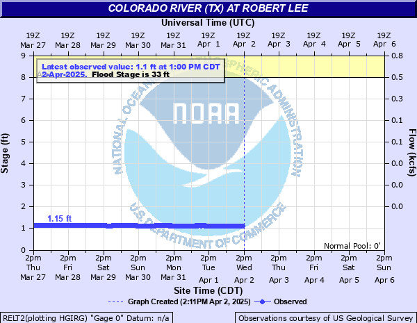
Colorado River (TX) at Robert Lee
Critical Stages
8' - Action
33' - Flood
35' - Moderate
37' - Major
Latest Observation
Updated: 11:00 AM CST 12/16/25
Status: No Flooding
Stage: 1.02 ft
Flow: 0.0013 kcfs
Forecast
Forecast not available for this location.
| Time | Stage (ft) | Flow (kcfs) |
|---|---|---|
| 11:00 AM 12/16 | 1.02 | 0.0013 |
| 10:45 AM 12/16 | 1.02 | 0.0013 |
| 10:30 AM 12/16 | 1.01 | 0.0013 |
| 10:15 AM 12/16 | 1.02 | 0.0013 |
| 10:00 AM 12/16 | 1.02 | 0.0013 |
| 9:45 AM 12/16 | 1.02 | 0.0013 |
| 9:30 AM 12/16 | 1.02 | 0.0013 |
| 9:15 AM 12/16 | 1.02 | 0.0013 |
| 9:00 AM 12/16 | 1.01 | 0.0013 |
| 8:45 AM 12/16 | 1.01 | 0.0013 |
| 8:30 AM 12/16 | 1 | 0.0012 |
| 8:15 AM 12/16 | 1 | 0.0012 |
| 8:00 AM 12/16 | 1.01 | 0.0013 |
| 7:45 AM 12/16 | 1.01 | 0.0013 |
| 7:30 AM 12/16 | 1.01 | 0.0013 |
| 7:15 AM 12/16 | 1.01 | 0.0013 |
| 7:00 AM 12/16 | 1.01 | 0.0013 |
| 6:45 AM 12/16 | 1.01 | 0.0013 |
| 6:30 AM 12/16 | 1.01 | 0.0013 |
| 6:15 AM 12/16 | 1.01 | 0.0013 |
| 6:00 AM 12/16 | 1.02 | 0.0013 |
| 5:45 AM 12/16 | 1.02 | 0.0013 |
| 5:30 AM 12/16 | 1.02 | 0.0013 |
| 5:15 AM 12/16 | 1.03 | 0.0013 |
| 5:00 AM 12/16 | 1.02 | 0.0013 |
| 4:45 AM 12/16 | 1.02 | 0.0013 |
| 4:30 AM 12/16 | 1.02 | 0.0013 |
| 4:15 AM 12/16 | 1.01 | 0.0013 |
| 4:00 AM 12/16 | 1.01 | 0.0013 |
| 3:45 AM 12/16 | 1.01 | 0.0013 |
37' -
Major flooding will occur. The approaches to the bridge on Highway 208 will be flooded and impassible. Structures in Robert Lee along the river will be threatened.
33' -
Minor flooding of ranch land will occur. Secondary roads and low water crossings will be flooded.
| Date | Stage (ft) |
|---|---|
| Oct 13, 1957 | 26.7 |
| Apr 25, 1924 | 25.5 |
| Apr 1, 1922 | 25.5 |
| Jun 22, 1939 | 21.7 |
| Jul 9, 1945 | 21.15 |
| Sep 9, 1980 | 20.63 |
| Jul 8, 1948 | 20.61 |
| Aug 19, 1953 | 20.15 |
| Jun 10, 1989 | 14.07 |
| Jun 19, 1982 | 11.12 |
Data provided by the National Weather Service.