Ochlockonee River near Concord (CR 12)
Critical Stages
33' - Action
36' - Flood
38' - Moderate
44' - Major
Latest Observation
Updated: 5:45 PM EST 12/15/25
Status: Low Threshold
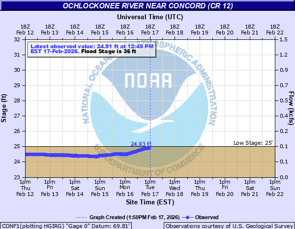
Stage: 24.54 ft
Flow: 0.104 kcfs
Forecast
Forecast not available for this location.
| Time | Stage (ft) | Flow (kcfs) |
|---|---|---|
| 5:45 PM 12/15 | 24.54 | 0.104 |
| 5:30 PM 12/15 | 24.54 | 0.104 |
| 5:15 PM 12/15 | 24.54 | 0.104 |
| 5:00 PM 12/15 | 24.54 | 0.104 |
| 4:45 PM 12/15 | 24.54 | 0.104 |
| 4:30 PM 12/15 | 24.54 | 0.104 |
| 4:15 PM 12/15 | 24.54 | 0.104 |
| 4:00 PM 12/15 | 24.55 | 0.104 |
| 3:45 PM 12/15 | 24.53 | 0.103 |
| 3:30 PM 12/15 | 24.52 | 0.102 |
| 3:15 PM 12/15 | 24.52 | 0.102 |
| 3:00 PM 12/15 | 24.56 | 0.105 |
| 2:45 PM 12/15 | 24.55 | 0.104 |
| 2:30 PM 12/15 | 24.53 | 0.103 |
| 2:15 PM 12/15 | 24.51 | 0.102 |
| 2:00 PM 12/15 | 24.53 | 0.103 |
| 1:45 PM 12/15 | 24.54 | 0.104 |
| 1:30 PM 12/15 | 24.55 | 0.104 |
| 1:15 PM 12/15 | 24.57 | 0.106 |
| 1:00 PM 12/15 | 24.58 | 0.107 |
| 12:45 PM 12/15 | 24.56 | 0.105 |
| 12:30 PM 12/15 | 24.56 | 0.105 |
| 12:15 PM 12/15 | 24.55 | 0.104 |
| 12:00 PM 12/15 | 24.58 | 0.107 |
| 11:45 AM 12/15 | 24.57 | 0.106 |
| 11:30 AM 12/15 | 24.58 | 0.107 |
| 11:15 AM 12/15 | 24.56 | 0.105 |
| 11:00 AM 12/15 | 24.58 | 0.107 |
| 10:45 AM 12/15 | 24.58 | 0.107 |
| 10:30 AM 12/15 | 24.59 | 0.107 |
44' -
Major flood level. Homes flood along county highway 12.
38.5' -
County highway 12 may become closed to vehicular traffic.
36' -
Primary access to homes along county highway 12 on the east bank of the river in Leon County may become restricted.
| Date | Stage (ft) |
|---|---|
| Aug 25, 2008 | 45.71 |
| Apr 4, 2009 | 44.71 |
| Feb 27, 2013 | 43.1 |
| Dec 27, 2014 | 41.67 |
| Jul 13, 2005 | 41.5 |
| Apr 4, 2016 | 41.29 |
| Mar 10, 2003 | 39.79 |
| Dec 6, 2018 | 39.52 |
| Aug 21, 2013 | 39.14 |
| Mar 20, 2014 | 38.8 |
| Apr 22, 2014 | 38.72 |
| Jan 6, 2021 | 38.64 |
| Jan 25, 2010 | 38.56 |
| Jan 25, 2017 | 38.07 |
| Dec 19, 2018 | 37.92 |
| Mar 30, 2016 | 37.41 |
| Feb 18, 2004 | 37.3 |
| Mar 19, 2001 | 37.1 |
| Jul 26, 2013 | 36.99 |
| May 3, 2014 | 36.78 |
Data provided by the National Weather Service.