Withlacoochee River near Pinetta - CR 150 (in NAVD88)
Critical Stages
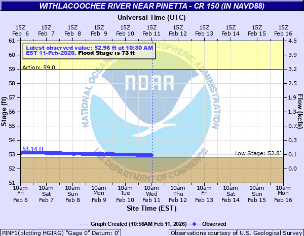
59' - Action
73' - Flood
79' - Moderate
83' - Major
Latest Observation
Updated: 5:30 PM EST 12/15/25
Status: Low Threshold
Stage: 52.73 ft
Flow: 0.0327 kcfs
Forecast
Forecast not available for this location.
| Time | Stage (ft) | Flow (kcfs) |
|---|---|---|
| 6:30 PM 12/15 | 52.73 | 0.0327 |
| 6:15 PM 12/15 | 52.73 | 0.0327 |
| 6:00 PM 12/15 | 52.73 | 0.0327 |
| 5:45 PM 12/15 | 52.73 | 0.0327 |
| 5:30 PM 12/15 | 52.73 | 0.0327 |
| 5:15 PM 12/15 | 52.73 | 0.0327 |
| 5:00 PM 12/15 | 52.73 | 0.0327 |
| 4:45 PM 12/15 | 52.73 | 0.0327 |
| 4:30 PM 12/15 | 52.72 | 0.0321 |
| 4:15 PM 12/15 | 52.72 | 0.0321 |
| 4:00 PM 12/15 | 52.72 | 0.0321 |
| 3:45 PM 12/15 | 52.72 | 0.0321 |
| 3:30 PM 12/15 | 52.72 | 0.0321 |
| 3:15 PM 12/15 | 52.72 | 0.0321 |
| 3:00 PM 12/15 | 52.72 | 0.0321 |
| 2:45 PM 12/15 | 52.72 | 0.0321 |
| 2:30 PM 12/15 | 52.73 | 0.0327 |
| 2:15 PM 12/15 | 52.73 | 0.0327 |
| 2:00 PM 12/15 | 52.73 | 0.0327 |
| 1:45 PM 12/15 | 52.73 | 0.0327 |
| 1:30 PM 12/15 | 52.73 | 0.0327 |
| 1:15 PM 12/15 | 52.73 | 0.0327 |
| 1:00 PM 12/15 | 52.72 | 0.0321 |
| 12:45 PM 12/15 | 52.73 | 0.0327 |
| 12:30 PM 12/15 | 52.73 | 0.0327 |
| 12:15 PM 12/15 | 52.73 | 0.0327 |
| 12:00 PM 12/15 | 52.74 | 0.0333 |
| 11:45 AM 12/15 | 52.73 | 0.0327 |
| 11:30 AM 12/15 | 52.73 | 0.0327 |
| 11:15 AM 12/15 | 52.73 | 0.0327 |
83' -
Numerous roads near the river are impassible. Significant impacts to structures near the river are expected.
81' -
Homes in northeast Madison County near the river are subject to flooding. NW 16 Avenue in Hamilton County is subject to closure.
80' -
In Hamilton County, water approaches NW 16 Avenue 1 mile north of CR 152. Multiple structures are impacted along NW 36th Terrace.
79.5' -
The Bellview Bridge is subject to closure.
78' -
In Hamilton County, portions of NW 36th Terrace begin to flood south of NW 36th Way. Flooding begins to surround more homes at the end of NW 36th Terrace.
76' -
Several roads near the river in Madison County become impassable. In Hamilton County, water begins to flood back yards of homes along NW 36th Terrace. Flooding continues to worsen at the Florida Campsites, with portions of the area becoming inaccessible.
73' -
Roads near the river on the west bank continue to flood in Madison County. Water begins to come over the bank at the Florida Campsites in Hamilton County.
71' -
NE Oak Hill Road starts to flood in low lying areas near the river in Madison County.
| Date | Stage (ft) |
|---|---|
| Apr 8, 2009 | 87.84 |
| Apr 5, 1948 | 85.14 |
| Mar 3, 2013 | 83.8 |
| Mar 8, 1991 | 83.48 |
| Mar 3, 2013 | 83.34 |
| Aug 15, 1928 | 83.25 |
| Mar 11, 1984 | 82.7 |
| Mar 15, 1998 | 82.67 |
| Dec 9, 1964 | 82.07 |
| Apr 10, 1973 | 81.6 |
| Apr 10, 1960 | 81.35 |
| Apr 8, 2016 | 80.45 |
| Feb 29, 2008 | 79.72 |
| Apr 19, 1975 | 79.6 |
| Mar 12, 1959 | 79.51 |
| May 7, 1964 | 79.51 |
| Apr 23, 1961 | 79.09 |
| Dec 31, 2014 | 78.84 |
| Feb 19, 1995 | 78.12 |
| Mar 30, 1944 | 78.07 |
Data provided by the National Weather Service.