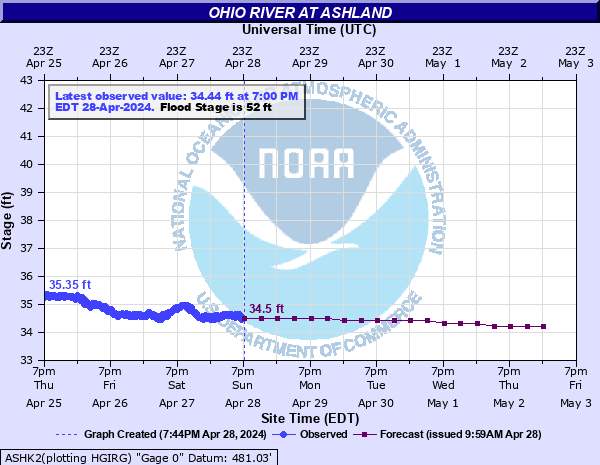
Ohio River at Ashland
Critical Stages
50' - Action
52' - Flood
56.6' - Moderate
65.5' - Major
Latest Observation
Updated: 12:00 AM EST 12/5/25
Status: No Flooding
Stage: 34.49 ft
Flow: -999 kcfs
Forecast
| Time | Stage (ft) | Flow (kcfs) |
|---|---|---|
| 1 AM 12/5 | 34.8 | -999 |
| 7 AM 12/5 | 34.8 | -999 |
| 1 PM 12/5 | 34.7 | -999 |
| 7 PM 12/5 | 34.7 | -999 |
| 1 AM 12/6 | 34.6 | -999 |
| 7 AM 12/6 | 34.6 | -999 |
| 1 PM 12/6 | 34.6 | -999 |
| 7 PM 12/6 | 34.6 | -999 |
| 1 AM 12/7 | 34.6 | -999 |
| 7 AM 12/7 | 34.6 | -999 |
| 1 PM 12/7 | 34.6 | -999 |
| 7 PM 12/7 | 34.6 | -999 |
| 1 AM 12/8 | 34.5 | -999 |
| 7 AM 12/8 | 34.5 | -999 |
| 1 PM 12/8 | 34.5 | -999 |
| 7 PM 12/8 | 34.5 | -999 |
| 1 AM 12/9 | 34.5 | -999 |
| 7 AM 12/9 | 34.5 | -999 |
| Time | Stage (ft) | Flow (kcfs) |
|---|---|---|
| 12:00 AM 12/5 | 34.49 | -999 |
| 11:45 PM 12/4 | 34.47 | -999 |
| 11:30 PM 12/4 | 34.46 | -999 |
| 11:15 PM 12/4 | 34.49 | -999 |
| 11:00 PM 12/4 | 34.53 | -999 |
| 10:45 PM 12/4 | 34.55 | -999 |
| 10:30 PM 12/4 | 34.42 | -999 |
| 10:15 PM 12/4 | 34.52 | -999 |
| 10:00 PM 12/4 | 34.52 | -999 |
| 9:45 PM 12/4 | 34.52 | -999 |
| 9:30 PM 12/4 | 34.52 | -999 |
| 9:15 PM 12/4 | 34.54 | -999 |
| 9:00 PM 12/4 | 34.55 | -999 |
| 8:45 PM 12/4 | 34.5 | -999 |
| 8:30 PM 12/4 | 34.52 | -999 |
| 8:15 PM 12/4 | 34.6 | -999 |
| 8:00 PM 12/4 | 34.48 | -999 |
| 7:45 PM 12/4 | 34.52 | -999 |
| 7:30 PM 12/4 | 34.58 | -999 |
| 7:15 PM 12/4 | 34.55 | -999 |
| 7:00 PM 12/4 | 34.63 | -999 |
| 6:45 PM 12/4 | 34.63 | -999 |
| 6:30 PM 12/4 | 34.56 | -999 |
| 6:15 PM 12/4 | 34.56 | -999 |
| 6:00 PM 12/4 | 34.58 | -999 |
| 5:45 PM 12/4 | 34.63 | -999 |
| 5:30 PM 12/4 | 34.59 | -999 |
| 5:15 PM 12/4 | 34.65 | -999 |
| 5:00 PM 12/4 | 34.6 | -999 |
| 4:45 PM 12/4 | 34.63 | -999 |
66.5' -
CSX Railroad closed in east end of Ashland near Catlettsburg KY.
65.8' -
River overtops the low point of the bank at the foot of Houston Street in Russell and flows overland to Ganners Branch.
65.5' -
US Routes 23 and 60 floods in the east end of Ashland. US Route 23 one quarter of a mile west of Ashland floods.
64.5' -
CSX Railroad closed in Russell.
63' -
US Route 60 floods in Catlettsburg.
60' -
The flood gate at Oakland Avenue in Catlettsburg is closed.
56.6' -
General flooding of areas around Ashland outside of the flood wall.
56' -
The flood gate in Catlettsburg at 26th and Front Street is closed.
55.5' -
KY Route 3 floods in Catlettsburg.
52' -
Minor flooding of roads in low lying areas begin to flood due to backwater from creeks.
50' -
Catlettsburg flood gate at 15th and Center Street is closed.
| Date | Stage (ft) |
|---|---|
| Jan 27, 1937 | 74.21 |
| Mar 31, 1913 | 70.6 |
| Feb 12, 1888 | 69.3 |
| Apr 17, 1948 | 65.9 |
| Mar 9, 1945 | 64.45 |
| Jan 2, 1943 | 64 |
| Mar 8, 1955 | 63.83 |
| Mar 23, 1936 | 63.3 |
| Mar 21, 1933 | 62.1 |
| Feb 5, 1939 | 61.2 |
| Apr 24, 1940 | 61 |
| Feb 4, 1950 | 61 |
| Mar 1, 1962 | 60.95 |
| Mar 5, 1997 | 60.79 |
| Mar 9, 1967 | 60.44 |
| May 9, 1958 | 59.9 |
| Mar 9, 1963 | 59.72 |
| Mar 13, 1964 | 59.69 |
| Mar 4, 1945 | 59.64 |
| Jan 25, 1927 | 59.3 |
Data provided by the National Weather Service.