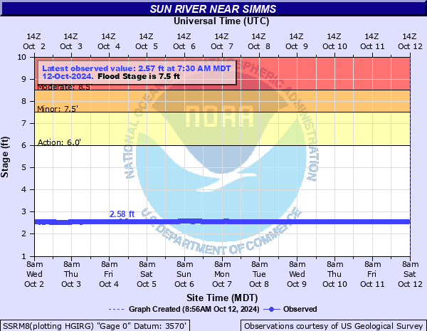
Sun River near Simms
Critical Stages
6' - Action
7.5' - Flood
8.5' - Moderate
10.5' - Major
Latest Observation
Updated: 7:30 PM MST 12/10/25
Status: No Flooding
Stage: 2.67 ft
Flow: -999 kcfs
Forecast
Forecast not available for this location.
| Time | Stage (ft) | Flow (kcfs) |
|---|---|---|
| 8:30 PM 12/10 | 2.66 | -999 |
| 8:15 PM 12/10 | 2.65 | -999 |
| 8:00 PM 12/10 | 2.66 | -999 |
| 7:45 PM 12/10 | 2.66 | -999 |
| 7:30 PM 12/10 | 2.67 | -999 |
| 7:15 PM 12/10 | 2.67 | -999 |
| 7:00 PM 12/10 | 2.67 | -999 |
| 6:45 PM 12/10 | 2.67 | -999 |
| 6:30 PM 12/10 | 2.68 | -999 |
| 6:15 PM 12/10 | 2.67 | -999 |
| 6:00 PM 12/10 | 2.68 | -999 |
| 5:45 PM 12/10 | 2.67 | -999 |
| 5:30 PM 12/10 | 2.67 | -999 |
| 5:15 PM 12/10 | 2.67 | -999 |
| 5:00 PM 12/10 | 2.67 | -999 |
| 4:45 PM 12/10 | 2.66 | -999 |
| 4:30 PM 12/10 | 2.66 | -999 |
| 4:15 PM 12/10 | 2.66 | -999 |
| 4:00 PM 12/10 | 2.66 | -999 |
| 3:45 PM 12/10 | 2.66 | -999 |
| 3:30 PM 12/10 | 2.66 | -999 |
| 3:15 PM 12/10 | 2.66 | -999 |
| 3:00 PM 12/10 | 2.66 | -999 |
| 2:45 PM 12/10 | 2.66 | -999 |
| 2:30 PM 12/10 | 2.66 | -999 |
| 2:15 PM 12/10 | 2.65 | -999 |
| 2:00 PM 12/10 | 2.65 | -999 |
| 1:45 PM 12/10 | 2.65 | -999 |
| 1:30 PM 12/10 | 2.64 | -999 |
| 1:15 PM 12/10 | 2.65 | -999 |
12' -
Major flooding. More than 100,000 acres flood.
10.8' -
At 10.8 Feet - June 20 2018 - Flooding in the city of Sun River similar to 2011. Most streets under water. Photos estimate water 2 to 4 feet deep. Highway 200 Closed from the 89 Junction all the way to the 287 Junction. Roger's Pass had a culvert washout which closed that section.
10.7' -
June 2018 - 1st and 2nd street flood in Sun River. Gravel washed away roadway, exposing optic cables. In Fort Shaw - North Fort Shaw Road completely destroyed. Culverts under roadway were exposed.
9.1' -
May 27, 2019 - At 9.1 feet - Streets and homes in Sun River flooded. Not as bad as the 2018 flood. Highway 200 had water over the highway, with flaggers. Water around homes. Fields did flood.
9' -
Much of the valley is flooded. Highway 200 flooded. Many homes as well as agricultural land floods.
8.5' -
Hwy 200 through town of Sun River, between 1st St and 3rd St, under water. Significant inundation of town between river to W, N, and E of town to beyond W Carroll St/Steell St. Sun River-Cascade Rd inundated for approx 1/3 mile to south of town.
8' -
Water starting to cover Hwy 200 between 1st St and 2nd ST. River well out of banks W, N and E of town and filling old oxbows near town and Hwy 200.
7.5' -
River out of banks and across highway at Sun River (town). Water over Fairfield Road. River within banks at Simms and Fort Shaw. About two dozen homes in Sun River (town) become isolated.
7' -
Minor overflow between Fort Shaw and Sun River (town) where the river meanders and gets into the old river bed.
6.5' -
Some overflow between Fort Shaw and Sun Siver (town) where the river meanders and gets into the old river bed.
6' -
River is bankfull.
| Date | Stage (ft) |
|---|---|
| Jun 9, 1964 | 13.7 |
| Jun 20, 1975 | 12.48 |
| Jun 20, 2018 | 10.75 |
| Jun 8, 2011 | 9.87 |
| May 27, 2019 | 9.15 |
| Jun 4, 1953 | 8.3 |
| May 12, 2018 | 8.1 |
| May 26, 2008 | 8.08 |
| Jun 2, 1972 | 8.04 |
| May 22, 1981 | 7.9 |
| May 15, 1976 | 7.88 |
| Jun 7, 2012 | 7.87 |
| Jun 1, 1967 | 7.79 |
| Jun 13, 1997 | 7.36 |
| May 29, 1971 | 7.15 |
| Jun 17, 1974 | 7.14 |
| Jun 7, 1978 | 6.77 |
| Jul 1, 1969 | 6.68 |
| Jun 6, 1970 | 6.51 |
| Jun 24, 2002 | 6.46 |
Data provided by the National Weather Service.