Marais Des Cygnes River at Ottawa
Critical Stages
25' - Action
30' - Flood
33' - Moderate
45' - Major
Latest Observation
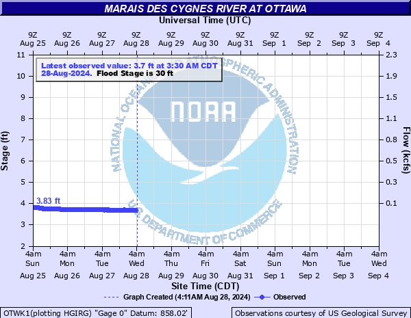
Updated: 3:30 PM CST 12/15/25
Status: No Flooding
Stage: 3.65 ft
Flow: 0.0458 kcfs
Forecast
Forecast not available for this location.
| Time | Stage (ft) | Flow (kcfs) |
|---|---|---|
| 4:30 PM 12/15 | 3.64 | 0.0448 |
| 4:15 PM 12/15 | 3.64 | 0.0448 |
| 4:00 PM 12/15 | 3.64 | 0.0448 |
| 3:45 PM 12/15 | 3.64 | 0.0448 |
| 3:30 PM 12/15 | 3.65 | 0.0458 |
| 3:15 PM 12/15 | 3.65 | 0.0458 |
| 3:00 PM 12/15 | 3.65 | 0.0458 |
| 2:45 PM 12/15 | 3.66 | 0.0468 |
| 2:30 PM 12/15 | 3.66 | 0.0468 |
| 2:15 PM 12/15 | 3.66 | 0.0468 |
| 2:00 PM 12/15 | 3.66 | 0.0468 |
| 1:45 PM 12/15 | 3.66 | 0.0468 |
| 1:30 PM 12/15 | 3.66 | 0.0468 |
| 1:15 PM 12/15 | 3.66 | 0.0468 |
| 1:00 PM 12/15 | 3.66 | 0.0468 |
| 12:45 PM 12/15 | 3.66 | 0.0468 |
| 12:30 PM 12/15 | 3.67 | 0.0478 |
| 12:15 PM 12/15 | 3.67 | 0.0478 |
| 12:00 PM 12/15 | 3.67 | 0.0478 |
| 11:45 AM 12/15 | 3.66 | 0.0468 |
| 11:30 AM 12/15 | 3.67 | 0.0478 |
| 11:15 AM 12/15 | 3.67 | 0.0478 |
| 11:01 AM 12/15 | -9999 | -999 |
| 11:00 AM 12/15 | 3.67 | 0.0478 |
| 10:45 AM 12/15 | 3.68 | 0.0488 |
| 10:30 AM 12/15 | 3.67 | 0.0478 |
| 10:15 AM 12/15 | 3.67 | 0.0478 |
| 10:00 AM 12/15 | 3.67 | 0.0478 |
| 9:45 AM 12/15 | 3.67 | 0.0478 |
| 9:30 AM 12/15 | 3.67 | 0.0478 |
37' -
Flood barriers are closed on Main Street in north Ottawa. Also flooding occurs in parts of east and west Ottawa due to backwater from the river along creeks. Homes are threatened by flood waters in parts of west and east Ottawa.
31' -
Lowland areas near the river continue to flood.
30' -
Neosho Road east of Ottawa floods.
| Date | Stage (ft) |
|---|---|
| Jul 11, 1951 | 42.97 |
| Jul 13, 1844 | 41.5 |
| Jul 1, 2007 | 41 |
| Nov 17, 1928 | 39.05 |
| Nov 2, 1998 | 38.92 |
| Sep 14, 1961 | 34.95 |
| Jun 27, 1969 | 34.58 |
| May 17, 1995 | 34.33 |
| May 22, 2019 | 34.16 |
| Jun 24, 2019 | 34.03 |
| Oct 12, 1973 | 34.01 |
| Oct 12, 1973 | 34.009998321533 |
| Jul 22, 1993 | 33.87 |
| Jul 22, 1993 | 33.869998931885 |
| Aug 1, 2019 | 33.79 |
| May 1, 2019 | 33.73 |
| Jun 7, 1965 | 33.64 |
| Jun 22, 1967 | 33.63 |
| May 24, 2015 | 33.31 |
| May 27, 2016 | 33.29 |
Data provided by the National Weather Service.