Stranger Creek near Tonganoxie
Critical Stages
18' - Action
23' - Flood
30' - Moderate
35' - Major
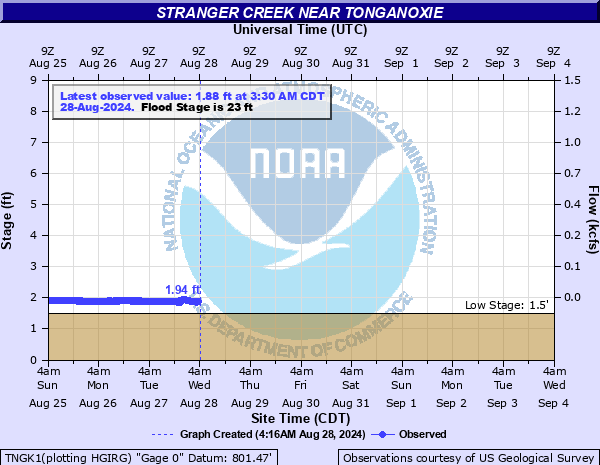
Latest Observation
Updated: 3:30 PM CST 12/15/25
Status: No Flooding
Stage: 1.97 ft
Flow: -999 kcfs
Forecast
Forecast not available for this location.
| Time | Stage (ft) | Flow (kcfs) |
|---|---|---|
| 4:30 PM 12/15 | 1.96 | -999 |
| 4:15 PM 12/15 | 1.96 | -999 |
| 4:00 PM 12/15 | 1.96 | -999 |
| 3:45 PM 12/15 | 1.96 | -999 |
| 3:30 PM 12/15 | 1.97 | -999 |
| 3:15 PM 12/15 | 1.97 | -999 |
| 3:00 PM 12/15 | 1.99 | -999 |
| 2:45 PM 12/15 | 1.99 | -999 |
| 2:30 PM 12/15 | 1.99 | -999 |
| 2:15 PM 12/15 | 1.98 | -999 |
| 2:00 PM 12/15 | 1.98 | -999 |
| 1:45 PM 12/15 | 1.99 | -999 |
| 1:30 PM 12/15 | 2 | -999 |
| 1:15 PM 12/15 | 1.99 | -999 |
| 1:00 PM 12/15 | 2 | -999 |
| 12:45 PM 12/15 | 1.99 | -999 |
| 12:30 PM 12/15 | 1.99 | -999 |
| 12:15 PM 12/15 | 1.99 | -999 |
| 12:00 PM 12/15 | 2.01 | -999 |
| 11:45 AM 12/15 | 2.05 | -999 |
| 11:30 AM 12/15 | 2.06 | -999 |
| 11:15 AM 12/15 | 1.9 | -999 |
| 11:00 AM 12/15 | 1.89 | -999 |
| 10:45 AM 12/15 | 1.9 | -999 |
| 10:30 AM 12/15 | 1.89 | -999 |
| 10:15 AM 12/15 | 1.89 | -999 |
| 10:00 AM 12/15 | 1.89 | -999 |
| 9:45 AM 12/15 | 1.88 | -999 |
| 9:30 AM 12/15 | 1.88 | -999 |
| 9:15 AM 12/15 | 1.88 | -999 |
34.7' -
Water overtops the Highway 40 bridge.
29.6' -
The west approach to the Highway 40 bridge is under water.
29.2' -
Water reaches the bottom of the Highway 40 bridge.
25' -
County Highway 6 floods about 3 miles east of Tonganoxie.
23' -
Low-lying farmland along the creek floods.
| Date | Stage (ft) |
|---|---|
| Sep 13, 1977 | 29.88 |
| Jun 21, 2001 | 29.81 |
| Oct 13, 1961 | 29.7 |
| Oct 2, 2005 | 29.36 |
| Jun 10, 1982 | 28.52 |
| Oct 11, 1985 | 27.8 |
| May 7, 2007 | 27.8 |
| Oct 5, 1998 | 27.74 |
| May 27, 2016 | 27.43 |
| May 16, 1990 | 27.42 |
| Jul 7, 1986 | 27.29 |
| Jun 12, 1967 | 27.25 |
| Sep 23, 1965 | 27.24 |
| Jun 7, 1996 | 27.1 |
| Oct 13, 1973 | 27.09 |
| Jun 28, 1999 | 27.05 |
| Sep 24, 1985 | 26.9 |
| Jul 10, 1993 | 26.83 |
| Sep 22, 1970 | 26.54 |
| Sep 14, 1961 | 26.51 |
Data provided by the National Weather Service.