Shoal Creek near Iron City
Critical Stages
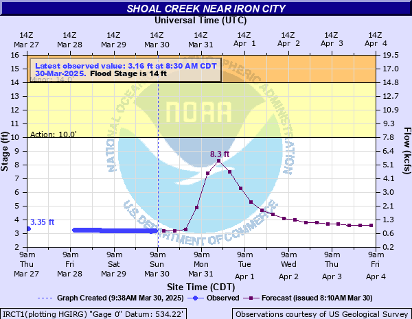
10' - Action
14' - Flood
19' - Moderate
22' - Major
Latest Observation
Updated: 10:30 PM CST 12/14/25
Status: No Flooding
Stage: 2.03 ft
Flow: 0.252 kcfs
Forecast
| Time | Stage (ft) | Flow (kcfs) |
|---|---|---|
| 12 AM 12/15 | 2.1 | 0.284 |
| 6 AM 12/15 | 2.1 | 0.284 |
| 12 PM 12/15 | 2.1 | 0.284 |
| 6 PM 12/15 | 2 | 0.239 |
| 12 AM 12/16 | 2 | 0.239 |
| 6 AM 12/16 | 2 | 0.239 |
| 12 PM 12/16 | 2 | 0.239 |
| 6 PM 12/16 | 2 | 0.239 |
| 12 AM 12/17 | 2 | 0.239 |
| 6 AM 12/17 | 2 | 0.239 |
| 12 PM 12/17 | 2 | 0.239 |
| 6 PM 12/17 | 2 | 0.239 |
| 12 AM 12/18 | 2 | 0.239 |
| 6 AM 12/18 | 2 | 0.239 |
| 12 PM 12/18 | 2 | 0.239 |
| 6 PM 12/18 | 2 | 0.239 |
| 12 AM 12/19 | 2 | 0.239 |
| 6 AM 12/19 | 2 | 0.239 |
| Time | Stage (ft) | Flow (kcfs) |
|---|---|---|
| 10:30 PM 12/14 | 2.03 | 0.252 |
| 10:15 PM 12/14 | 2.02 | 0.248 |
| 10:00 PM 12/14 | 2.03 | 0.252 |
| 9:45 PM 12/14 | 2.02 | 0.248 |
| 9:30 PM 12/14 | 2.02 | 0.248 |
| 9:15 PM 12/14 | 2.02 | 0.248 |
| 9:00 PM 12/14 | 2.03 | 0.252 |
| 8:45 PM 12/14 | 2.03 | 0.252 |
| 8:30 PM 12/14 | 2.03 | 0.252 |
| 8:15 PM 12/14 | 2.03 | 0.252 |
| 8:00 PM 12/14 | 2.02 | 0.248 |
| 7:45 PM 12/14 | 2.02 | 0.248 |
| 7:30 PM 12/14 | 2.03 | 0.252 |
| 7:15 PM 12/14 | 2.03 | 0.252 |
| 7:00 PM 12/14 | 2.03 | 0.252 |
| 6:45 PM 12/14 | 2.02 | 0.248 |
| 6:30 PM 12/14 | 2.02 | 0.248 |
| 6:15 PM 12/14 | 2.02 | 0.248 |
| 6:00 PM 12/14 | 2.02 | 0.248 |
| 5:45 PM 12/14 | 2.02 | 0.248 |
| 5:30 PM 12/14 | 2.02 | 0.248 |
| 5:15 PM 12/14 | 2.02 | 0.248 |
| 5:00 PM 12/14 | 2.02 | 0.248 |
| 4:45 PM 12/14 | 2.03 | 0.252 |
| 4:30 PM 12/14 | 2.02 | 0.248 |
| 4:15 PM 12/14 | 2.02 | 0.248 |
| 4:00 PM 12/14 | 2.02 | 0.248 |
| 3:45 PM 12/14 | 2.03 | 0.252 |
| 3:30 PM 12/14 | 2.02 | 0.248 |
| 3:15 PM 12/14 | 2.02 | 0.248 |
32' -
Flooding continues to severely impact Hwy 242 and Holly Creek Rd leading into Iron City from the north and Hwy 227 leading in from the east. These roads are impassable. Properties and structures in Iron City between Oak St and Wayland Springs Rd are also impacted, as well as properties along N Walnut St, S Walnut St, and Leech Ave.
30' -
Many main roads near Iron City continue to be impacted, including Wayland Springs Rd - Hwy 242, Railroad Rd east of Hwy 242, Railroad Bed Rd near the intersection with Hwy 242, and Tidwell Hollow Rd. In Iron City, water continues to impact S Walnut St, Leech Ave, and Park Dr, and approaches structures at Ver Plank Enterprises on N Walnut Street. Water also approaches Iron City Rd – Hwy 227 east of Iron City and Holly Creek Rd at Etheredge Manufacturing which may be impassable at higher levels.
28' -
Widespread flooding continues to impact roads and properties along the creek, including Wayland Springs Rd – Hwy 242, Railroad Rd, Railroad Bed Rd near Hwy 242, S Walnut St, Leech Ave, Park Dr, Tidwell Hollow Rd, and the railroad tracks near the bridge over Shoal Creek.
26' -
Widespread flooding along Shoal Creek is impacting roads and properties near Iron City, including Wayland Springs Rd – Hwy 242 north of Iron City, Railroad Rd east of Hwy 242 and Railroad Bed Rd near Hwy 242, S Walnut St at the intersection with Leech Ave and Hannah St, and Park Dr. Water approaches Leech Ave between S Poplar St and S Walnut St, Tidwell Hollow Rd near Tidwell Hollow, and the railroad tracks near the bridge over Shoal Creek.
24' -
Significant flooding is impacting roads and properties along the creek and in the Iron City area including Wayland Springs Rd – Hwy 242 north of Iron City, Railroad Rd east of Hwy 242, S Walnut St at the intersection with Leech Ave and Hannah St, and Park Dr. Water approaches Railroad Bed Rd near Hwy 242, portions Ver Plank Enterprises on N Walnut Street, and residential properties near the intersection of Iron City Rd – Hwy 227 and Wayland Springs Rd – Hwy 242.
22' -
Railroad Rd east of Hwy 242 and Wayland Springs Rd – Hwy 242 north of Iron City are flooded and impassable. Water approaches Park Dr and S Walnut St at the intersection with Leech Ave and Hannah St.
20' -
Water begins to flood portions of Railroad Rd east of Hwy 242, and approaches Wayland Springs Rd – Hwy 242 north of Iron City. These roads may be impassable at higher levels.
18' -
Water approaches portions of Railroad Rd east of Hwy 242 and most of Iron City Park in Iron City is flooded.
16' -
Agricultural areas along the creek, portions of Iron City Park, and Sycamore Campground are inundated. Portions of properties on Barney Ln in Rocky Hollow begin to be impacted.
14' -
Low lying and agricultural areas along the river begin to be impacted, as well as Iron City Park and the Sycamore Campground.
| Date | Stage (ft) |
|---|---|
| Mar 1, 1902 | 28.1 |
| Mar 21, 1955 | 26.56 |
| Jul 14, 1998 | 24.5 |
| Jan 24, 2002 | 23.21 |
| May 2, 2010 | 23.12 |
| May 6, 2003 | 22.54 |
| Oct 19, 2004 | 22.26 |
| May 26, 1991 | 21.99 |
| Feb 18, 1991 | 19.8 |
| Oct 6, 1983 | 19.79 |
| Dec 26, 1983 | 19.79 |
| Mar 31, 2021 | 19.44 |
| Feb 5, 2004 | 19.16 |
| Mar 27, 1994 | 19.1 |
| Apr 27, 2011 | 19.08 |
| Feb 17, 2001 | 18.5 |
| Dec 3, 1991 | 18.5 |
| Feb 23, 2019 | 18.47 |
| Sep 7, 1990 | 18.14 |
| Feb 4, 1990 | 18.14 |
Data provided by the National Weather Service.