« Back to Pittsburg County Rivers
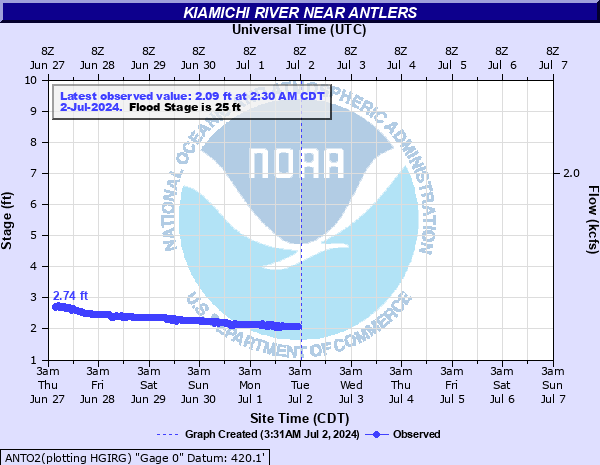
Kiamichi River near Antlers
Critical Stages
24' - Action
25' - Flood
29' - Moderate
35' - Major
Latest Observation
Updated: 9:30 AM CST 12/6/25
Status: No Flooding
Stage: 3.08 ft
Flow: 0.245 kcfs
Forecast
Forecast not available for this location.
| Time | Stage (ft) | Flow (kcfs) |
|---|---|---|
| 9:30 AM 12/6 | 3.08 | 0.245 |
| 9:15 AM 12/6 | 3.08 | 0.245 |
| 9:00 AM 12/6 | 3.09 | 0.247 |
| 8:45 AM 12/6 | 3.08 | 0.245 |
| 8:30 AM 12/6 | 3.09 | 0.247 |
| 8:15 AM 12/6 | 3.09 | 0.247 |
| 8:00 AM 12/6 | 3.09 | 0.247 |
| 7:45 AM 12/6 | 3.09 | 0.247 |
| 7:30 AM 12/6 | 3.09 | 0.247 |
| 7:15 AM 12/6 | 3.09 | 0.247 |
| 7:00 AM 12/6 | 3.09 | 0.247 |
| 6:45 AM 12/6 | 3.09 | 0.247 |
| 6:30 AM 12/6 | 3.1 | 0.25 |
| 6:15 AM 12/6 | 3.1 | 0.25 |
| 6:00 AM 12/6 | 3.1 | 0.25 |
| 5:45 AM 12/6 | 3.1 | 0.25 |
| 5:30 AM 12/6 | 3.1 | 0.25 |
| 5:15 AM 12/6 | 3.11 | 0.252 |
| 5:00 AM 12/6 | 3.11 | 0.252 |
| 4:45 AM 12/6 | 3.11 | 0.252 |
| 4:30 AM 12/6 | 3.11 | 0.252 |
| 4:15 AM 12/6 | 3.11 | 0.252 |
| 4:00 AM 12/6 | 3.12 | 0.255 |
| 3:45 AM 12/6 | 3.12 | 0.255 |
| 3:30 AM 12/6 | 3.11 | 0.252 |
| 3:15 AM 12/6 | 3.12 | 0.255 |
| 3:00 AM 12/6 | 3.12 | 0.255 |
| 2:45 AM 12/6 | 3.12 | 0.255 |
| 2:30 AM 12/6 | 3.12 | 0.255 |
| 2:15 AM 12/6 | 3.12 | 0.255 |
40' -
disasterous flooding occurs along the Kiamichi River. Water floods the parking lot of a grocery store near Moyers. Backwater flooding may cause Ethel Road near Beaver Creek to be closed. Numerous structures become flooded along the west bank of the Kiamichi River near Moyers. Buildings on campgrounds are flooded by several feet. This will approach the record flood event which occurred on May, 4 1990 when the Kiamichi River crested at 40.44 feet. This is an extremely dangerous and life threatening situation.
37' -
numerous structures become flooded along the west bank of the Kiamichi River near Moyers. Buildings on campgrounds are flooded by several feet. This will be similar to the flooding that occurred on December 28, 2015 when the river reached 37.39 feet. This will exceed the flooding which occurred on April 8, 2002 when the river crested at 36.13 feet. The City of Antlers may see backwater flooding that could close Ethel Road near Beaver Creek. This is an extremely dangerous and life threatening situation.
35' -
widespread flooding occurs along the west bank of the Kiamichi River near Moyers. Buildings on campgrounds become flooded. This will exceed the flooding which occurred on July 3, 2007 when the river crested at 34.51 feet. The City of Antlers is not threatened directly by the Kiamichi flooding but backwater flooding occurs along Beaver Creek closing Ethel Road. This is a dangerous situation.
33' -
several permanent structures on the campgrounds along the west bank of Kiamichi River near Moyers become flooded. The City of Antlers is not threatened directly by the Kiamichi flooding but backwater flooding may occur along Beaver Creek east of town.
31' -
moderate flooding occurs along campgrounds on the west bank of the Kiamichi River near Moyers. Permanent buildings on the campgrounds become flooded.
29' -
moderate flooding occurs along the west bank of the Kiamichi River near Moyers. Some permanent buildings on the campgrounds become isolated.
27' -
minor flooding occurs along the west bank of the Kiamichi River near Moyers. Campers should move to higher ground.
25' -
minor flooding begins along the west bank of the Kiamichi River near Moyers. Campers along the river should move to higher ground.
24' -
faster flows along the river are expected but no flooding occurs. Interests near the river should continue to monitor later forecasts. Campers near the river should move to higher ground.
| Date | Stage (ft) |
|---|---|
| May 4, 1990 | 40.44 |
| Mar 28, 1977 | 38.33 |
| Dec 28, 2015 | 37.39 |
| Apr 8, 2002 | 36.13 |
| Oct 21, 1984 | 34.58 |
| Jul 3, 2007 | 34.51 |
| May 10, 1993 | 34.19 |
| May 26, 2015 | 33.97 |
| May 21, 2015 | 33.75 |
| May 23, 1979 | 33.7 |
| May 25, 2015 | 33.59 |
| Mar 20, 2002 | 33.08 |
| Nov 26, 1973 | 32.62 |
| May 23, 2015 | 32.61 |
| May 25, 2016 | 31.44 |
| May 30, 2015 | 31.3 |
| May 2, 2019 | 31.3 |
| Mar 21, 2012 | 31.2 |
| May 22, 2013 | 30.68 |
| Jan 6, 1998 | 30.3 |
Data provided by the National Weather Service.