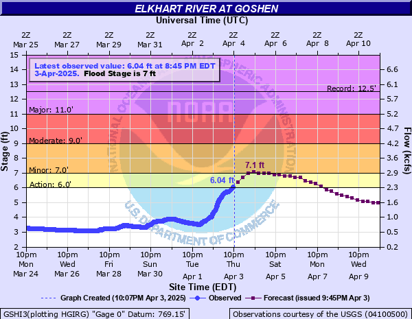
Elkhart River at Goshen
Critical Stages
6' - Action
7' - Flood
9' - Moderate
11' - Major
Latest Observation
Updated: 1:45 AM EST 12/8/25
Status: No Flooding
Stage: 2.04 ft
Flow: 0.0974 kcfs
Forecast
Forecast not available for this location.
| Time | Stage (ft) | Flow (kcfs) |
|---|---|---|
| 1:45 AM 12/8 | 2.04 | 0.0974 |
| 1:30 AM 12/8 | 2.04 | 0.0974 |
| 1:15 AM 12/8 | 2.04 | 0.0974 |
| 1:00 AM 12/8 | 2.04 | 0.0974 |
| 12:45 AM 12/8 | 2.04 | 0.0974 |
| 12:30 AM 12/8 | 2.04 | 0.0974 |
| 12:15 AM 12/8 | 2.04 | 0.0974 |
| 12:00 AM 12/8 | 2.04 | 0.0974 |
| 11:45 PM 12/7 | 2.04 | 0.0974 |
| 11:30 PM 12/7 | 2.04 | 0.0974 |
| 11:15 PM 12/7 | 2.05 | 0.0988 |
| 11:00 PM 12/7 | 2.04 | 0.0974 |
| 10:45 PM 12/7 | 2.05 | 0.0988 |
| 10:30 PM 12/7 | 2.05 | 0.0988 |
| 10:15 PM 12/7 | 2.05 | 0.0988 |
| 10:00 PM 12/7 | 2.05 | 0.0988 |
| 9:45 PM 12/7 | 2.05 | 0.0988 |
| 9:30 PM 12/7 | 2.05 | 0.0988 |
| 9:15 PM 12/7 | 2.05 | 0.0988 |
| 9:00 PM 12/7 | 2.05 | 0.0988 |
| 8:45 PM 12/7 | 2.05 | 0.0988 |
| 8:30 PM 12/7 | 2.05 | 0.0988 |
| 8:15 PM 12/7 | 2.05 | 0.0988 |
| 8:00 PM 12/7 | 2.05 | 0.0988 |
| 7:45 PM 12/7 | 2.05 | 0.0988 |
| 7:30 PM 12/7 | 2.05 | 0.0988 |
| 7:15 PM 12/7 | 2.05 | 0.0988 |
| 7:00 PM 12/7 | 2.05 | 0.0988 |
| 6:45 PM 12/7 | 2.05 | 0.0988 |
| 6:30 PM 12/7 | 2.05 | 0.0988 |
13' -
At this level, the Goshen wastewater plant operations are likely impacted.
12.5' -
All-time record flood is in progress with many residences flooded. Water as high as four feet can be expected in some commercial areas.
11' -
A major flood is in progress with several streets and US 33 through Goshen flooded. Southeast Elkhart also floods. Many evacuations of residential areas are necessary.
10' -
Several residential streets are flooded in Goshen. US 33 begins to flood. Flooding from Chicago Poke Plaza reaches residential areas near the intersection of Indiana and Berkey Avenues in Goshen.
9' -
Water closes Chicago Avenue and Denver Street in Goshen. Rogers Park is completely flooded.
8' -
Some residential and commercial properties near SR 119 are affected by high water.
7' -
The river reaches flood stage. Goshen, Shanklin, and Rogers Park in Goshen begin to flood. Island, Studebaker, and American Parks in Elkhart begin to flood.
5' -
The very lowest areas along the Elkhart River begin to flood.
1.86' -
Lowest river observation during 2012 drought.
| Date | Stage (ft) |
|---|---|
| Feb 21, 2018 | 12.53 |
| Mar 14, 1982 | 11.94 |
| Feb 24, 1985 | 11.87 |
| Dec 30, 1990 | 11.03 |
| Mar 17, 1982 | 10.46 |
| Feb 6, 2008 | 10.4 |
| Mar 5, 1979 | 10.33 |
| Jul 10, 1951 | 10.33 |
| Oct 11, 1954 | 10.27 |
| Jun 9, 1993 | 10.2 |
| Apr 4, 1950 | 10.15 |
| Jan 9, 2008 | 10.07 |
| Mar 29, 1985 | 10.05 |
| Mar 23, 1978 | 9.76 |
| May 13, 2002 | 9.6 |
| Jan 5, 1993 | 9.6 |
| May 25, 1943 | 9.46 |
| May 12, 1943 | 9.38 |
| Dec 14, 1927 | 9.3 |
| Apr 30, 1956 | 9.25 |
Data provided by the National Weather Service.