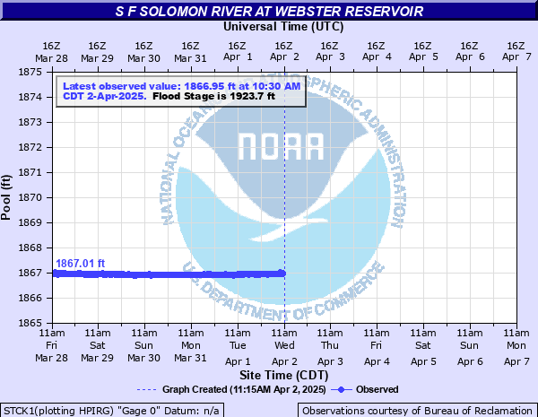
S F Solomon River at Webster Reservoir
Critical Stages
1913.7' - Action
1923.7' - Flood
Moderate
1939' - Major
Latest Observation
Updated: 2:30 AM CST 12/16/25
Status: No Flooding
Stage: 1865.96 ft
Flow: -999 kcfs
Forecast
Forecast not available for this location.
| Time | Stage (ft) | Flow (kcfs) |
|---|---|---|
| 2:30 AM 12/16 | 1865.96 | -999 |
| 2:15 AM 12/16 | 1865.96 | -999 |
| 2:00 AM 12/16 | 1865.96 | -999 |
| 1:45 AM 12/16 | 1865.96 | -999 |
| 1:30 AM 12/16 | 1865.97 | -999 |
| 1:15 AM 12/16 | 1865.96 | -999 |
| 1:00 AM 12/16 | 1865.96 | -999 |
| 12:45 AM 12/16 | 1865.95 | -999 |
| 12:30 AM 12/16 | 1865.95 | -999 |
| 12:15 AM 12/16 | 1865.97 | -999 |
| 12:00 AM 12/16 | 1865.96 | -999 |
| 11:45 PM 12/15 | 1865.96 | -999 |
| 11:30 PM 12/15 | 1865.95 | -999 |
| 11:15 PM 12/15 | 1865.96 | -999 |
| 11:00 PM 12/15 | 1865.95 | -999 |
| 10:45 PM 12/15 | 1865.97 | -999 |
| 10:30 PM 12/15 | 1865.96 | -999 |
| 10:15 PM 12/15 | 1865.96 | -999 |
| 10:00 PM 12/15 | 1865.96 | -999 |
| 9:45 PM 12/15 | 1865.96 | -999 |
| 9:30 PM 12/15 | 1865.96 | -999 |
| 9:15 PM 12/15 | 1865.96 | -999 |
| 9:00 PM 12/15 | 1865.96 | -999 |
| 8:45 PM 12/15 | 1865.96 | -999 |
| 8:30 PM 12/15 | 1865.96 | -999 |
| 8:15 PM 12/15 | 1865.96 | -999 |
| 8:00 PM 12/15 | 1865.96 | -999 |
| 7:45 PM 12/15 | 1865.96 | -999 |
| 7:30 PM 12/15 | 1865.96 | -999 |
| 7:15 PM 12/15 | 1865.96 | -999 |
1944' -
This elevation represents the height, or crest, of the dam.
1938' -
This elevation represents the maximum surcharge at this reservoir.
1923.7' -
This elevation represents the top of the flood control pool.
1892.45' -
This elevation represents the bottom of the flood control pool.
1884.6' -
This is the elevation when water begins to flow over the spillway.
1860' -
This elevation represents the bottom of the conservation pool.
Historical crest information is not available.
Data provided by the National Weather Service.