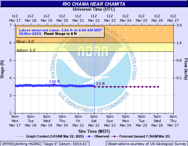
Rio Chama near Chamita
Critical Stages
5.5' - Action
6' - Flood
8' - Moderate
11.5' - Major
Latest Observation
Updated: 10:00 AM MST 12/16/25
Status: No Flooding
Stage: 4.72 ft
Flow: 0.639 kcfs
Forecast
| Time | Stage (ft) | Flow (kcfs) |
|---|---|---|
| 5 PM 12/16 | 4.7 | 0.625 |
| 11 PM 12/16 | 4.7 | 0.625 |
| 5 AM 12/17 | 4.7 | 0.625 |
| 11 AM 12/17 | 4.5 | 0.462 |
| 5 PM 12/17 | 4.4 | 0.388 |
| 11 PM 12/17 | 4.4 | 0.388 |
| 5 AM 12/18 | 4.4 | 0.388 |
| 11 AM 12/18 | 4.4 | 0.388 |
| 5 PM 12/18 | 4.4 | 0.388 |
| 11 PM 12/18 | 4.4 | 0.388 |
| 5 AM 12/19 | 4.4 | 0.388 |
| 11 AM 12/19 | 4.4 | 0.388 |
| 5 PM 12/19 | 4.3 | 0.322 |
| 11 PM 12/19 | 4.3 | 0.322 |
| 5 AM 12/20 | 4.3 | 0.322 |
| 11 AM 12/20 | 4.3 | 0.322 |
| 5 PM 12/20 | 4.3 | 0.322 |
| 11 PM 12/20 | 4.3 | 0.322 |
| 5 AM 12/21 | 4.3 | 0.322 |
| Time | Stage (ft) | Flow (kcfs) |
|---|---|---|
| 10:00 AM 12/16 | 4.72 | 0.639 |
| 9:45 AM 12/16 | 4.72 | 0.639 |
| 9:30 AM 12/16 | 4.72 | 0.639 |
| 9:15 AM 12/16 | 4.72 | 0.639 |
| 9:00 AM 12/16 | 4.72 | 0.639 |
| 8:45 AM 12/16 | 4.72 | 0.639 |
| 8:30 AM 12/16 | 4.72 | 0.639 |
| 8:15 AM 12/16 | 4.72 | 0.639 |
| 8:00 AM 12/16 | 4.72 | 0.639 |
| 7:45 AM 12/16 | 4.72 | 0.639 |
| 7:30 AM 12/16 | 4.72 | 0.639 |
| 7:15 AM 12/16 | 4.72 | 0.639 |
| 7:00 AM 12/16 | 4.73 | 0.646 |
| 6:45 AM 12/16 | 4.72 | 0.639 |
| 6:30 AM 12/16 | 4.73 | 0.646 |
| 6:15 AM 12/16 | 4.72 | 0.639 |
| 6:00 AM 12/16 | 4.72 | 0.639 |
| 5:45 AM 12/16 | 4.73 | 0.646 |
| 5:30 AM 12/16 | 4.72 | 0.639 |
| 5:15 AM 12/16 | 4.73 | 0.646 |
| 5:00 AM 12/16 | 4.72 | 0.639 |
| 4:45 AM 12/16 | 4.72 | 0.639 |
| 4:30 AM 12/16 | 4.72 | 0.639 |
| 4:15 AM 12/16 | 4.72 | 0.639 |
| 4:00 AM 12/16 | 4.72 | 0.639 |
| 3:45 AM 12/16 | 4.72 | 0.639 |
| 3:30 AM 12/16 | 4.72 | 0.639 |
| 3:15 AM 12/16 | 4.72 | 0.639 |
| 3:00 AM 12/16 | 4.72 | 0.639 |
| 2:45 AM 12/16 | 4.72 | 0.639 |
11.5' -
Water getting dangerously close to bottom of bridges on highway 285 and state route 74. Debris in river may get caught on bridge supports and send water over the roadway. Significant flooding to properties along the Rio Chama and Rio Ojo Caliente is occurring and private roads along the river are impassable.
8' -
Properties along the Rio Chama and southern reach of the Rio Ojo Caliente are flooded. Private roadways within several hundred yards of the river are impassable.
6' -
Properties in the flood plain along the Rio Chama and near the junction of the Rio Ojo Caliente will see water in their yards. Impacts can include bank erosion and damage to wells and septic tanks. These impacts will increase in severity at higher river levels.
5.5' -
Bankfull stage. Properties immediately adjacent to the river upstream of the bridge on SR-74 and especially near the junction with the Rio Ojo Caliente may see water encroach onto low lying areas.
| Date | Stage (ft) |
|---|---|
| Aug 14, 1994 | 11.68 |
| May 22, 1920 | 10.45 |
| Aug 12, 1929 | 9.65 |
| Aug 29, 1969 | 9.56 |
| May 14, 1941 | 9.5 |
| Sep 18, 2013 | 9.14 |
| Apr 23, 1942 | 8.8 |
| Aug 9, 1967 | 7.95 |
| Sep 29, 1998 | 7.29 |
| Jun 18, 1984 | 7.29 |
| Jun 13, 1991 | 6.89 |
| May 11, 2005 | 6.86 |
| May 22, 1995 | 6.74 |
| Jul 21, 2009 | 6.66 |
| Jul 29, 2000 | 6.59 |
| Apr 25, 2008 | 6.33 |
Data provided by the National Weather Service.