« Back to Pueblo Mountain Park Rivers
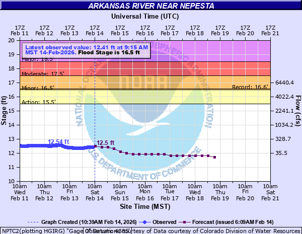
Arkansas River near Nepesta
Critical Stages
15.5' - Action
16.5' - Flood
17.5' - Moderate
18.5' - Major
Latest Observation
Updated: 12:15 AM MST 12/15/25
Status: No Flooding
Stage: 12.87 ft
Flow: 0.362 kcfs
Forecast
| Time | Stage (ft) | Flow (kcfs) |
|---|---|---|
| 5 AM 12/15 | 12.9 | 0.377 |
| 11 AM 12/15 | 12.9 | 0.377 |
| 5 PM 12/15 | 12.9 | 0.377 |
| 11 PM 12/15 | 12.9 | 0.377 |
| 5 AM 12/16 | 12.9 | 0.377 |
| 11 AM 12/16 | 12.9 | 0.377 |
| 5 PM 12/16 | 12.9 | 0.377 |
| 11 PM 12/16 | 12.9 | 0.377 |
| 5 AM 12/17 | 12.9 | 0.377 |
| 11 AM 12/17 | 12.9 | 0.377 |
| 5 PM 12/17 | 12.9 | 0.377 |
| 11 PM 12/17 | 12.9 | 0.377 |
| 5 AM 12/18 | 12.9 | 0.377 |
| 11 AM 12/18 | 12.9 | 0.377 |
| 5 PM 12/18 | 12.9 | 0.377 |
| 11 PM 12/18 | 12.9 | 0.377 |
| 5 AM 12/19 | 12.9 | 0.377 |
| Time | Stage (ft) | Flow (kcfs) |
|---|---|---|
| 12:15 AM 12/15 | 12.87 | 0.362 |
| 12:00 AM 12/15 | 12.86 | 0.357 |
| 11:45 PM 12/14 | 12.86 | 0.357 |
| 11:30 PM 12/14 | 12.86 | 0.357 |
| 11:15 PM 12/14 | 12.86 | 0.357 |
| 11:00 PM 12/14 | 12.85 | 0.352 |
| 10:45 PM 12/14 | 12.86 | 0.357 |
| 10:30 PM 12/14 | 12.87 | 0.362 |
| 10:15 PM 12/14 | 12.86 | 0.357 |
| 10:00 PM 12/14 | 12.85 | 0.352 |
| 9:45 PM 12/14 | 12.87 | 0.362 |
| 9:30 PM 12/14 | 12.87 | 0.362 |
| 9:15 PM 12/14 | 12.87 | 0.362 |
| 9:00 PM 12/14 | 12.87 | 0.362 |
| 8:45 PM 12/14 | 12.86 | 0.357 |
| 8:30 PM 12/14 | 12.86 | 0.357 |
| 8:15 PM 12/14 | 12.85 | 0.352 |
| 8:00 PM 12/14 | 12.85 | 0.352 |
| 7:45 PM 12/14 | 12.87 | 0.362 |
| 7:30 PM 12/14 | 12.88 | 0.367 |
| 7:15 PM 12/14 | 12.87 | 0.362 |
| 7:00 PM 12/14 | 12.87 | 0.362 |
| 6:45 PM 12/14 | 12.87 | 0.362 |
| 6:30 PM 12/14 | 12.88 | 0.367 |
| 6:15 PM 12/14 | 12.88 | 0.367 |
| 6:00 PM 12/14 | 12.87 | 0.362 |
| 5:45 PM 12/14 | 12.87 | 0.362 |
| 5:30 PM 12/14 | 12.86 | 0.357 |
| 5:15 PM 12/14 | 12.87 | 0.362 |
| 5:00 PM 12/14 | 12.88 | 0.367 |
20' -
Major flood. Homes and roads along the river are flooded.
19.5' -
Major Flood. Water enters the Fowler area.
19' -
Major Flood. Water impacts homes near Nepesta. The flood plain is inundated..
18.5' -
Major Flood. Waters spill over Nepesta Road near the Nepesta Road Bridge. Major flooding of agricultural lands around Nepesta occurs. The river is entirely out of its channel.
18' -
Moderate Flood. Agricultural lands near Nepesta flood and the Oxford Ditch works may be damaged.
17.5' -
Moderate Flood. Agricultural lands near Nepesta flood.
16.5' -
Minor Flood. Agricultural lands near Nepesta are flooded.
15.5' -
Action Stage. Low-lying wetlands are flooded.
14.5' -
The river is bankfull. Low lying wetland areas along the channel begin to flood.
| Date | Stage (ft) |
|---|---|
| Jun 23, 2023 | 16.66 |
| May 21, 2015 | 16.56 |
| Jun 12, 2024 | 15.92 |
| Sep 14, 2013 | 15.62 |
| Jun 18, 2019 | 15.62 |
| Aug 26, 2006 | 15.52 |
| Jun 9, 2010 | 15.29 |
| Sep 16, 2011 | 15.04 |
| May 19, 1955 | 8.05 |
| May 16, 1957 | 8 |
| Aug 22, 1923 | 6.87 |
Data provided by the National Weather Service.