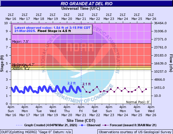
Rio Grande at Del Rio
Critical Stages
4.2' - Action
4.5' - Flood
4.7' - Moderate
7.5' - Major
Latest Observation
Updated: 10:15 AM CST 12/17/25
Status: No Flooding
Stage: 1.49 ft
Flow: 0.72 kcfs
Forecast
| Time | Stage (ft) | Flow (kcfs) |
|---|---|---|
| 12 PM 12/17 | 2.1 | 2.1 |
| 6 PM 12/17 | 1.6 | 0.923 |
| 12 AM 12/18 | 2.2 | 2.38 |
| 6 AM 12/18 | 1.6 | 0.923 |
| 12 PM 12/18 | 2.2 | 2.38 |
| 6 PM 12/18 | 1.5 | 0.738 |
| 12 AM 12/19 | 2.3 | 2.69 |
| 6 AM 12/19 | 1.6 | 0.923 |
| 12 PM 12/19 | 2.2 | 2.38 |
| 6 PM 12/19 | 1.5 | 0.738 |
| 12 AM 12/20 | 2.3 | 2.69 |
| 6 AM 12/20 | 1.6 | 0.923 |
| 12 PM 12/20 | 2.2 | 2.38 |
| 6 PM 12/20 | 1.5 | 0.738 |
| 12 AM 12/21 | 2.3 | 2.69 |
| 6 AM 12/21 | 1.6 | 0.923 |
| 12 PM 12/21 | 2.2 | 2.38 |
| 6 PM 12/21 | 1.5 | 0.738 |
| 12 AM 12/22 | 2.1 | 2.1 |
| 6 AM 12/22 | 1.6 | 0.923 |
| Time | Stage (ft) | Flow (kcfs) |
|---|---|---|
| 10:15 AM 12/17 | 1.49 | 0.72 |
| 10:00 AM 12/17 | 1.51 | 0.755 |
| 9:45 AM 12/17 | 1.52 | 0.773 |
| 9:30 AM 12/17 | 1.54 | 0.808 |
| 9:15 AM 12/17 | 1.56 | 0.845 |
| 9:00 AM 12/17 | 1.58 | 0.884 |
| 8:45 AM 12/17 | 1.59 | 0.903 |
| 8:30 AM 12/17 | 1.61 | 0.942 |
| 8:15 AM 12/17 | 1.63 | 0.982 |
| 8:00 AM 12/17 | 1.63 | 0.982 |
| 7:45 AM 12/17 | 1.65 | 1.02 |
| 7:30 AM 12/17 | 1.65 | 1.02 |
| 7:15 AM 12/17 | 1.65 | 1.02 |
| 7:00 AM 12/17 | 1.65 | 1.02 |
| 6:45 AM 12/17 | 1.64 | 1 |
| 6:30 AM 12/17 | 1.62 | 0.962 |
| 6:15 AM 12/17 | 1.61 | 0.942 |
| 6:00 AM 12/17 | 1.6 | 0.923 |
| 5:45 AM 12/17 | 1.6 | 0.923 |
| 5:30 AM 12/17 | 1.6 | 0.923 |
| 5:15 AM 12/17 | 1.62 | 0.962 |
| 5:00 AM 12/17 | 1.64 | 1 |
| 4:45 AM 12/17 | 1.66 | 1.04 |
| 4:30 AM 12/17 | 1.68 | 1.09 |
| 4:15 AM 12/17 | 1.72 | 1.17 |
| 4:00 AM 12/17 | 1.76 | 1.26 |
| 3:45 AM 12/17 | 1.79 | 1.32 |
| 3:30 AM 12/17 | 1.83 | 1.41 |
| 3:15 AM 12/17 | 1.87 | 1.51 |
| 3:00 AM 12/17 | 1.91 | 1.6 |
21' -
(6.4 meters), Massive flooding washes smaller homes and mobile homes downstream in the Vega Verde Subdivision and floods hundreds of homes. The approach to the Highway 377 International Bridge is under several feet of water. Homes, businesses, streets and bridges along San Felipe Street flood, including the Guyler Street bridge.
18' -
(5.5 meters), Massive flooding to the roofs of homes in the Vega Verde subdivision below Amistad Dam floods hundreds of homes and washes smaller homes and mobile homes downstream. The Highway 377 approach to the International Bridge floods.
14' -
(4.3 meteres), Hundreds of homes flood in the Vega Verde subdivision below Amistad Dam with water to the roofs of some. Smaller homes and mobile homes wash downstream. Flow is over a half mile wide in the flood plain between Amistad Dam and Highway 377. Life threatening conditions on the United States and Mexican sides.
11' -
(3.4 meters), Major flooding. Nearly all homes in the Vega Verde subdivision are now in the flow of the river and cut off.
10' -
(3.1 meters), Major flooding is occurring. Water reaches the entrance to the Ingram Readymix Plant on Cienegas Road just north of the intersection with Vega Verde Road. A small section of homes located between the 6600 and 7700 blocks of Vega Verde Road remain out of the river channel. Many homes and structures in the low-lying areas of Vega Verde Road are standing in the flow of the river.
8' -
(2.4 meters), Major flooding. Water reaches the intersection of Vega Verde and Old Foster Road. Many of the homes in the Vega Verde subdivision are now in the flow of the river.
6' -
(1.8 meters), Moderate lowland flooding occurs. Water is well over the road in the lowest section of the Vega Verde subdivision and is impassible by cars and trucks. Water surrounds some of the homes in the lowest areas of the subdivision. Water also partially encompasses several homes with water covering most of the back yard and coming close to some homes in the subdivision.
4.7' -
(1.4 meters), Moderate lowland flooding reaches the slab elevation of the lowest homes in the Vega Verde subdivision below Amistad Dam and cuts behind the lowest residential areas cutting them off.
4.4' -
(1.3 meters), Minor lowland flooding cuts off some residents in the Vega Verde Subdivision below Amistad Dam, and a low section of the road through the subdivision floods. The flow approaches the lowest homes in the subdivision.
4' -
(1.2 meters), The flow is overbanks into lowest areas of the flood plain, threatening to flood the road through the lowest sections of the Vega Verde subdivision.
| Date | Stage (ft) |
|---|---|
| Jun 28, 1954 | 38.25 |
| Sep 1, 1932 | 34.5 |
| Jun 24, 1948 | 33.6 |
| Sep 24, 1964 | 29.9 |
| Sep 5, 1935 | 24.5 |
| Jun 14, 1935 | 23.6 |
| Jul 26, 1949 | 21.1 |
| Jun 23, 1946 | 21 |
| Aug 8, 1949 | 20.5 |
| Jul 24, 1938 | 20.2 |
| Sep 18, 1941 | 17.3 |
| Sep 13, 1942 | 15.8 |
| Aug 23, 1998 | 15.7 |
| Jul 5, 2010 | 14.61 |
| Sep 21, 1974 | 14.08 |
| Sep 19, 1991 | 7.7 |
Data provided by the National Weather Service.