Black River near Bessemer
Critical Stages
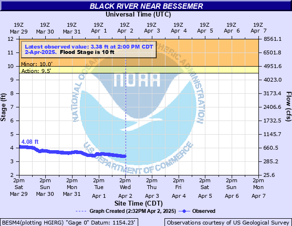
9.5' - Action
10' - Flood
12' - Moderate
14' - Major
Latest Observation
Updated: 8:00 AM CST 12/10/25
Status: No Flooding
Stage: 2.8 ft
Flow: 0.23 kcfs
Forecast
Forecast not available for this location.
| Time | Stage (ft) | Flow (kcfs) |
|---|---|---|
| 8:00 AM 12/10 | 2.8 | 0.23 |
| 7:45 AM 12/10 | 2.79 | 0.226 |
| 7:30 AM 12/10 | 2.8 | 0.23 |
| 7:15 AM 12/10 | 2.8 | 0.23 |
| 7:00 AM 12/10 | 2.8 | 0.23 |
| 6:45 AM 12/10 | 2.8 | 0.23 |
| 6:30 AM 12/10 | 2.8 | 0.23 |
| 6:15 AM 12/10 | 2.8 | 0.23 |
| 6:00 AM 12/10 | 2.8 | 0.23 |
| 5:45 AM 12/10 | 2.8 | 0.23 |
| 5:30 AM 12/10 | 2.8 | 0.23 |
| 5:15 AM 12/10 | 2.8 | 0.23 |
| 5:00 AM 12/10 | 2.8 | 0.23 |
| 4:45 AM 12/10 | 2.8 | 0.23 |
| 4:30 AM 12/10 | 2.8 | 0.23 |
| 4:15 AM 12/10 | 2.8 | 0.23 |
| 4:00 AM 12/10 | 2.8 | 0.23 |
| 3:45 AM 12/10 | 2.8 | 0.23 |
| 3:30 AM 12/10 | 2.8 | 0.23 |
| 3:15 AM 12/10 | 2.8 | 0.23 |
| 3:00 AM 12/10 | 2.8 | 0.23 |
| 2:45 AM 12/10 | 2.8 | 0.23 |
| 2:30 AM 12/10 | 2.8 | 0.23 |
| 2:15 AM 12/10 | 2.8 | 0.23 |
| 2:00 AM 12/10 | 2.8 | 0.23 |
| 1:45 AM 12/10 | 2.8 | 0.23 |
| 1:30 AM 12/10 | 2.8 | 0.23 |
| 1:15 AM 12/10 | 2.8 | 0.23 |
| 1:00 AM 12/10 | 2.8 | 0.23 |
| 12:45 AM 12/10 | 2.8 | 0.23 |
14' -
Water innundates the bridge on Hedbery Road and portions of Black River Road in the vicinity
12' -
Water reaches the bottom of Hedberg Road Bridge
10' -
Which is flood stage...water impacts low lying areas of properties along Black River Road and Hedberg Road
| Date | Stage (ft) |
|---|---|
| Apr 24, 1960 | 14.27 |
| Apr 17, 2002 | 13.54 |
| Apr 30, 2013 | 12.23 |
| May 12, 2003 | 12.16 |
| Aug 16, 1972 | 11.73 |
| Apr 23, 2019 | 11.41 |
| Apr 12, 2023 | 11.38 |
| Apr 12, 2001 | 9.93 |
| Apr 13, 1964 | 9.88 |
| Apr 2, 1963 | 9.84 |
| Jun 10, 1974 | 9.77 |
| Apr 21, 1957 | 9.76 |
| Apr 19, 2004 | 9.61 |
| Apr 17, 1971 | 9.55 |
| Jun 17, 2018 | 9.47 |
| Mar 27, 2007 | 9.43 |
| Apr 24, 2022 | 9.43 |
| Mar 31, 1967 | 9.05 |
| Apr 11, 2011 | 9.03 |
| Mar 16, 2016 | 8.99 |
Data provided by the National Weather Service.