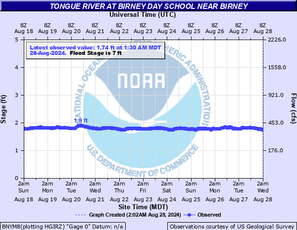
Tongue River at Birney Day School near Birney
Critical Stages
Action
7' - Flood
Moderate
Major
Latest Observation
Updated: 3:30 AM MST 12/16/25
Status: No Flooding
Stage: 1.47 ft
Flow: 0.255 kcfs
Forecast
Forecast not available for this location.
| Time | Stage (ft) | Flow (kcfs) |
|---|---|---|
| 3:30 AM 12/16 | 1.47 | 0.255 |
| 3:15 AM 12/16 | 1.47 | 0.255 |
| 3:00 AM 12/16 | 1.47 | 0.255 |
| 2:45 AM 12/16 | 1.47 | 0.255 |
| 2:30 AM 12/16 | 1.48 | 0.258 |
| 2:15 AM 12/16 | 1.48 | 0.258 |
| 2:00 AM 12/16 | 1.48 | 0.258 |
| 1:45 AM 12/16 | 1.46 | 0.252 |
| 1:30 AM 12/16 | 1.46 | 0.252 |
| 1:15 AM 12/16 | 1.47 | 0.255 |
| 1:00 AM 12/16 | 1.45 | 0.249 |
| 12:45 AM 12/16 | 1.45 | 0.249 |
| 12:30 AM 12/16 | 1.44 | 0.246 |
| 12:15 AM 12/16 | 1.45 | 0.249 |
| 12:00 AM 12/16 | 1.44 | 0.246 |
| 11:45 PM 12/15 | 1.44 | 0.246 |
| 11:30 PM 12/15 | 1.45 | 0.249 |
| 11:15 PM 12/15 | 1.45 | 0.249 |
| 11:00 PM 12/15 | 1.46 | 0.252 |
| 10:45 PM 12/15 | 1.46 | 0.252 |
| 10:30 PM 12/15 | 1.47 | 0.255 |
| 10:15 PM 12/15 | 1.47 | 0.255 |
| 10:00 PM 12/15 | 1.47 | 0.255 |
| 9:45 PM 12/15 | 1.48 | 0.258 |
| 9:30 PM 12/15 | 1.47 | 0.255 |
| 9:15 PM 12/15 | 1.48 | 0.258 |
| 9:00 PM 12/15 | 1.48 | 0.258 |
| 8:45 PM 12/15 | 1.48 | 0.258 |
| 8:30 PM 12/15 | 1.48 | 0.258 |
| 8:15 PM 12/15 | 1.46 | 0.252 |
9' -
Flooding concerns around Birney based on 2011 floods.
8' -
Flooding concerns at St. Labre and Ashland based on 2011 floods.
7.9' -
DES indicates no significant impacts below 8 feet during 2011 floods.
5' -
(OLD DATA) Low land crop/ranch graze land floods near birney.
| Date | Stage (ft) |
|---|---|
| May 31, 2019 | 9.49 |
| May 31, 2018 | 7.9 |
| Jun 12, 2011 | 7.3 |
| Jun 9, 2007 | 7.06 |
| Feb 8, 1996 | 6.92 |
| Jun 13, 2023 | 6.78 |
| Jun 1, 2014 | 6.76 |
| Jun 13, 1999 | 6.69 |
| Jun 5, 2015 | 6.6 |
| Jun 14, 1984 | 6.43 |
| Jun 13, 2010 | 6.03 |
| Jun 21, 2008 | 5.99 |
| Jun 17, 1997 | 5.94 |
| May 20, 2017 | 5.89 |
| Jun 22, 1995 | 5.84 |
| Jun 14, 2022 | 5.62 |
| May 31, 1996 | 5.28 |
| Jun 8, 1986 | 5.2 |
| May 23, 2005 | 5.19 |
| Jun 12, 2024 | 5.14 |
Data provided by the National Weather Service.