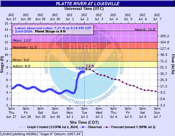
Platte River at Louisville
Critical Stages
8' - Action
9' - Flood
11' - Moderate
12' - Major
Latest Observation
Updated: 2:15 PM CST 12/15/25
Status: No Flooding
Stage: 4 ft
Flow: 7.58 kcfs
Forecast
Forecast not available for this location.
| Time | Stage (ft) | Flow (kcfs) |
|---|---|---|
| 2:15 PM 12/15 | 4 | 7.58 |
| 2:00 PM 12/15 | 3.97 | 7.47 |
| 1:45 PM 12/15 | 3.96 | 7.43 |
| 1:30 PM 12/15 | 3.99 | 7.54 |
| 1:15 PM 12/15 | 4 | 7.58 |
| 1:00 PM 12/15 | 4.01 | 7.66 |
| 12:45 PM 12/15 | 4.01 | 7.66 |
| 12:30 PM 12/15 | 4.03 | 7.81 |
| 12:15 PM 12/15 | 4.11 | 8.46 |
| 12:00 PM 12/15 | 4.09 | 8.3 |
| 11:45 AM 12/15 | 4.13 | 8.61 |
| 11:30 AM 12/15 | 4.17 | 8.93 |
| 11:15 AM 12/15 | 4.11 | 8.46 |
| 11:00 AM 12/15 | 4.05 | 7.97 |
| 10:45 AM 12/15 | 4.04 | 7.89 |
| 10:30 AM 12/15 | 4.06 | 8.05 |
| 10:15 AM 12/15 | 4.07 | 8.13 |
| 10:00 AM 12/15 | 4.07 | 8.13 |
| 9:45 AM 12/15 | 4.06 | 8.05 |
| 9:30 AM 12/15 | 4.01 | 7.66 |
| 9:15 AM 12/15 | 4.03 | 7.81 |
| 9:00 AM 12/15 | 4.04 | 7.89 |
| 8:45 AM 12/15 | 4.07 | 8.13 |
| 8:30 AM 12/15 | 4.17 | 8.93 |
| 8:15 AM 12/15 | 4.16 | 8.85 |
| 8:00 AM 12/15 | 4.16 | 8.85 |
| 7:45 AM 12/15 | 4.17 | 8.93 |
| 7:30 AM 12/15 | 4.19 | 9.1 |
| 7:15 AM 12/15 | 4.2 | 9.18 |
| 7:00 AM 12/15 | 4.23 | 9.42 |
17.5' -
Though unlikely to occur, water reaches the bottom of the Highway 50 bridge at this level.
13' -
Highway 50 just north of the river begins to flood.
12' -
Highway 31, north of the river, between Riha Road and Highway 50 begins to flood.
11' -
The Meadow levee on the north bank of the Highway 50 bridge may overtop. This along with increasing lowland flooding may begin to impact structures near the river.
9' -
The bike path at Highway 50 along the river begins to flood. Also, lowland flooding starts along both of the banks.
| Date | Stage (ft) |
|---|---|
| Mar 16, 2019 | 13.82 |
| Mar 30, 1960 | 12.45 |
| Jul 25, 1993 | 11.9 |
| Mar 10, 1993 | 11.47 |
| Jun 14, 1984 | 11.35 |
| Mar 20, 1978 | 10.83 |
| May 31, 2008 | 10.48 |
| Jun 17, 1957 | 10.35 |
| Jun 14, 2010 | 10.33 |
| Feb 22, 1982 | 9.99 |
| Mar 3, 1979 | 9.79 |
| Mar 24, 1987 | 9.72 |
| Aug 3, 1959 | 9.5 |
| Jun 19, 1983 | 9.36 |
| Jun 17, 1990 | 9.16 |
| May 29, 1995 | 9.12 |
| May 29, 2019 | 8.99 |
| Mar 18, 1979 | 8.88 |
| Feb 28, 1958 | 8.83 |
| Jun 28, 1999 | 8.77 |
Data provided by the National Weather Service.