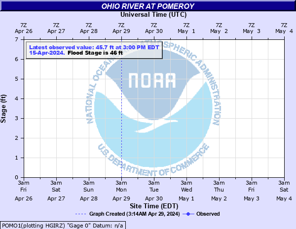
Ohio River at Pomeroy
Critical Stages
42' - Action
46' - Flood
48' - Moderate
50' - Major
Latest Observation
Updated: 7:03 PM LMT 12/31/00
Status: Obs Not Current
Stage: -999 ft
Flow: -999 kcfs
Forecast
Forecast not available for this location.
Observation history not available.
58' -
Pomeroy Courthouse begins to flood. Court and Lynn Streets and 2nd Avenue are flooded. Most of Pomeroy is flooded.
50' -
Pomeroy businesses along main are street flooded. Park and boat ramp in Mason are flooded.
48' -
Businesses along river in Pomeroy start to flood. Main street is flooded. Homes near the Pomeroy-Mason bridge on the West Virginia side start to flood.
46' -
Pomeroy parking lots and the river ampitheater are flooded along river. Main street starts to flood. Some secondary roads are flooded due to backwater.
42' -
Action stage. Low spot in the parking lot is flooded near the boat ramp.
| Date | Stage (ft) |
|---|---|
| Apr 1, 1913 | 68.8 |
| Jan 26, 1937 | 67.8 |
| Feb 11, 1884 | 64.6 |
| Mar 7, 1907 | 61.5 |
| Jan 2, 1943 | 57.6 |
| Dec 31, 1942 | 57.6 |
| Dec 1, 1847 | 57 |
| Mar 9, 1901 | 57 |
| Feb 8, 1883 | 57 |
| Apr 23, 1852 | 56.8 |
| Mar 21, 1936 | 56.6 |
| Mar 9, 1945 | 56.4 |
| Jan 23, 1862 | 55.6 |
| Jan 1, 1927 | 55.5 |
| Feb 6, 1939 | 54.5 |
| Feb 22, 1891 | 54.4 |
| Feb 19, 1832 | 54.3 |
| Apr 10, 1886 | 54 |
| Feb 26, 1897 | 53.8 |
| Mar 20, 1933 | 53.5 |
Data provided by the National Weather Service.