« Back to Republican City Rivers
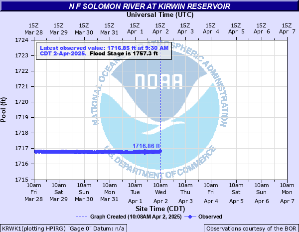
N F Solomon River at Kirwin Reservoir
Critical Stages
1747.3' - Action
1757.3' - Flood
Moderate
1774' - Major
Latest Observation
Updated: 5:30 PM CST 12/15/25
Status: No Flooding
Stage: 1711.71 ft
Flow: -999 kcfs
Forecast
Forecast not available for this location.
| Time | Stage (ft) | Flow (kcfs) |
|---|---|---|
| 5:30 PM 12/15 | 1711.71 | -999 |
| 5:15 PM 12/15 | 1711.72 | -999 |
| 5:00 PM 12/15 | 1711.72 | -999 |
| 4:45 PM 12/15 | 1711.71 | -999 |
| 4:30 PM 12/15 | 1711.71 | -999 |
| 4:15 PM 12/15 | 1711.72 | -999 |
| 4:00 PM 12/15 | 1711.72 | -999 |
| 3:45 PM 12/15 | 1711.71 | -999 |
| 3:30 PM 12/15 | 1711.71 | -999 |
| 3:15 PM 12/15 | 1711.71 | -999 |
| 3:00 PM 12/15 | 1711.72 | -999 |
| 2:45 PM 12/15 | 1711.71 | -999 |
| 2:30 PM 12/15 | 1711.71 | -999 |
| 2:15 PM 12/15 | 1711.71 | -999 |
| 2:00 PM 12/15 | 1711.71 | -999 |
| 1:45 PM 12/15 | 1711.71 | -999 |
| 1:30 PM 12/15 | 1711.71 | -999 |
| 1:15 PM 12/15 | 1711.72 | -999 |
| 1:00 PM 12/15 | 1711.71 | -999 |
| 12:45 PM 12/15 | 1711.72 | -999 |
| 12:30 PM 12/15 | 1711.71 | -999 |
| 12:15 PM 12/15 | 1711.71 | -999 |
| 12:00 PM 12/15 | 1711.71 | -999 |
| 11:45 AM 12/15 | 1711.71 | -999 |
| 11:30 AM 12/15 | 1711.71 | -999 |
| 11:15 AM 12/15 | 1711.72 | -999 |
| 11:00 AM 12/15 | 1711.71 | -999 |
| 10:45 AM 12/15 | 1711.71 | -999 |
| 10:30 AM 12/15 | 1711.71 | -999 |
| 10:15 AM 12/15 | 1711.71 | -999 |
1779' -
This elevation represents the height, or crest, of the dam.
1773' -
This elevation represents the maximum surcharge at this reservoir.
1757.3' -
This elevation represents the top of the flood control pool and when water begins to flow over the spillway.
1729.25' -
This elevation represents the bottom of the flood control pool.
1720' -
This is the elevation of the gated flood outlets.
1697' -
This elevation represents the bottom of the conservation pool.
Historical crest information is not available.
Data provided by the National Weather Service.