« Back to Roaring River State Park Rivers
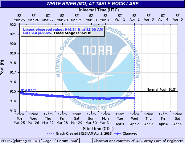
White River (MO) at Table Rock Lake
Critical Stages
Action
931' - Flood
Moderate
Major
Latest Observation
Updated: 7:00 AM CST 12/6/25
Status: No Flooding
Stage: 914.81 ft
Flow: -999 kcfs
Forecast
Forecast not available for this location.
| Time | Stage (ft) | Flow (kcfs) |
|---|---|---|
| 7:00 AM 12/6 | 914.81 | -999 |
| 6:30 AM 12/6 | 914.83 | -999 |
| 6:00 AM 12/6 | 914.83 | -999 |
| 5:30 AM 12/6 | 914.85 | -999 |
| 5:00 AM 12/6 | 914.85 | -999 |
| 4:30 AM 12/6 | 914.86 | -999 |
| 4:00 AM 12/6 | 914.86 | -999 |
| 3:30 AM 12/6 | 914.85 | -999 |
| 3:00 AM 12/6 | 914.85 | -999 |
| 2:30 AM 12/6 | 914.83 | -999 |
| 2:00 AM 12/6 | 914.83 | -999 |
| 1:30 AM 12/6 | 914.84 | -999 |
| 1:00 AM 12/6 | 914.84 | -999 |
| 12:30 AM 12/6 | 914.87 | -999 |
| 12:00 AM 12/6 | 914.87 | -999 |
| 11:30 PM 12/5 | 914.89 | -999 |
| 11:00 PM 12/5 | 914.89 | -999 |
| 10:30 PM 12/5 | 914.9 | -999 |
| 10:00 PM 12/5 | 914.9 | -999 |
| 9:30 PM 12/5 | 914.9 | -999 |
| 9:00 PM 12/5 | 914.9 | -999 |
| 8:30 PM 12/5 | 914.86 | -999 |
| 8:00 PM 12/5 | 914.86 | -999 |
| 7:30 PM 12/5 | 914.87 | -999 |
| 7:00 PM 12/5 | 914.87 | -999 |
| 6:30 PM 12/5 | 914.89 | -999 |
| 6:00 PM 12/5 | 914.89 | -999 |
| 5:30 PM 12/5 | 914.88 | -999 |
| 5:00 PM 12/5 | 914.88 | -999 |
| 4:30 PM 12/5 | 914.88 | -999 |
947' -
Top of dam.
931' -
Top of Flood Pool. Low lying areas near the lake flood.
| Date | Stage (ft) |
|---|---|
| Apr 27, 2011 | 935.47 |
| Apr 12, 2008 | 933.25 |
| May 10, 1961 | 932.52 |
Data provided by the National Weather Service.