« Back to Roaring River State Park Rivers
Shoal Creek (MO) near Joplin
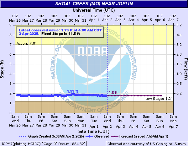
Critical Stages
7' - Action
11.5' - Flood
16' - Moderate
18' - Major
Latest Observation
Updated: 6:00 AM CST 12/6/25
Status: No Flooding
Stage: 2 ft
Flow: 0.146 kcfs
Forecast
| Time | Stage (ft) | Flow (kcfs) |
|---|---|---|
| 12 PM 12/6 | 2 | 0.146 |
| 6 PM 12/6 | 2 | 0.146 |
| 12 AM 12/7 | 2 | 0.146 |
| 6 AM 12/7 | 2 | 0.146 |
| 12 PM 12/7 | 2 | 0.146 |
| 6 PM 12/7 | 2 | 0.146 |
| 12 AM 12/8 | 2 | 0.146 |
| 6 AM 12/8 | 2 | 0.146 |
| 12 PM 12/8 | 2 | 0.146 |
| 6 PM 12/8 | 2 | 0.146 |
| 12 AM 12/9 | 2 | 0.146 |
| 6 AM 12/9 | 2 | 0.146 |
| 12 PM 12/9 | 2 | 0.146 |
| 6 PM 12/9 | 2 | 0.146 |
| 12 AM 12/10 | 2 | 0.146 |
| 6 AM 12/10 | 2 | 0.146 |
| 12 PM 12/10 | 2 | 0.146 |
| 6 PM 12/10 | 2 | 0.146 |
| 12 AM 12/11 | 2 | 0.146 |
| 6 AM 12/11 | 2 | 0.146 |
| Time | Stage (ft) | Flow (kcfs) |
|---|---|---|
| 7:00 AM 12/6 | 2 | 0.146 |
| 6:00 AM 12/6 | 2 | 0.146 |
| 5:00 AM 12/6 | 2 | 0.146 |
| 4:00 AM 12/6 | 1.99 | 0.143 |
| 3:00 AM 12/6 | 1.98 | 0.141 |
| 2:00 AM 12/6 | 1.99 | 0.143 |
| 1:00 AM 12/6 | 1.98 | 0.141 |
| 12:00 AM 12/6 | 1.99 | 0.143 |
| 11:00 PM 12/5 | 1.97 | 0.138 |
| 10:00 PM 12/5 | 1.99 | 0.143 |
| 9:00 PM 12/5 | 1.97 | 0.138 |
| 8:00 PM 12/5 | 1.99 | 0.143 |
| 7:00 PM 12/5 | 1.98 | 0.141 |
| 6:00 PM 12/5 | 1.97 | 0.138 |
| 5:00 PM 12/5 | 1.96 | 0.136 |
| 4:00 PM 12/5 | 1.97 | 0.138 |
| 3:00 PM 12/5 | 1.98 | 0.141 |
| 2:00 PM 12/5 | 1.97 | 0.138 |
| 1:00 PM 12/5 | 1.98 | 0.141 |
| 12:00 PM 12/5 | 1.98 | 0.141 |
| 11:00 AM 12/5 | 1.99 | 0.143 |
| 10:00 AM 12/5 | 2 | 0.146 |
| 9:00 AM 12/5 | 2.01 | 0.149 |
| 8:00 AM 12/5 | 2 | 0.146 |
| 7:00 AM 12/5 | 2.02 | 0.151 |
| 6:00 AM 12/5 | 2.01 | 0.149 |
| 5:00 AM 12/5 | 2.01 | 0.149 |
| 4:00 AM 12/5 | 2 | 0.146 |
| 3:00 AM 12/5 | 2 | 0.146 |
| 2:00 AM 12/5 | 2 | 0.146 |
23.39' -
this is the record crest set on December 28, 2015. Widespread flooding occurs in the floodplain along the river.
22.96' -
this is the crest set on April 29, 2017. Widespread flooding occurs in the floodplain along the river.
22' -
flooding occurs at Reddings Mill Water Treatment Plant.
18' -
major Flood Stage. Castle Drive on the southwest side of Shoal Creek across from the gage site floods.
17.8' -
flooding occurs on Castle Drive on the southwest side of Shoal Creek across from the gage site.
16.5' -
the Jackson Street Low Water Bridge at Glendale Road near I-44 floods and becomes impassable.
16' -
Moderate flooding begins at this site. Portions of Shoal Creek Estates Flood.
15' -
portions of Shoal Cliff Drive flood.
14.5' -
back up of water occurs on Silver Creek and floods low lying roadways near the confluence with Shoal Creek.
14' -
flood waters innundate Wildcat State Park.
13' -
Riverside Campground downstream from the gage near Coyote Drive and McClelland Boulevard floods.
11.5' -
flood stage beginning January 31, 2018. River Road near Shoal Creek Estates floods.
7' -
low lying areas in the Wildcat Park Access Area downstream from the gage flood.
| Date | Stage (ft) |
|---|---|
| Apr 19, 1941 | 28 |
| Dec 27, 2015 | 23.39 |
| Apr 29, 2017 | 22.96 |
| Oct 10, 2009 | 18.81 |
| Mar 19, 2008 | 18.28 |
| Jun 11, 1995 | 17.24 |
| May 6, 2022 | 16.87 |
| Sep 25, 1993 | 16.84 |
| May 18, 1943 | 16.8 |
| Apr 26, 2011 | 16.7 |
| Jun 24, 2019 | 16.63 |
| Nov 4, 1974 | 16.62 |
| Jun 24, 2019 | 16.55 |
| Apr 11, 2008 | 16.45 |
| Jul 3, 1976 | 16.43 |
| May 23, 2019 | 16.3 |
| May 28, 2021 | 16.15 |
| May 24, 2011 | 15.96 |
| May 23, 2019 | 15.62 |
| Jul 7, 1993 | 15.5 |
Data provided by the National Weather Service.