« Back to Ruby Lake National Wildlife Refuge Rivers
Humboldt River at Palisade
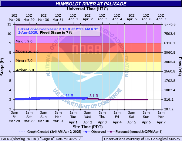
Critical Stages
6' - Action
7' - Flood
8' - Moderate
9' - Major
Latest Observation
Updated: 4:10 PM PST 12/15/25
Status: No Flooding
Stage: 1.17 ft
Flow: 0.049 kcfs
Forecast
| Time | Stage (ft) | Flow (kcfs) |
|---|---|---|
| 5 PM 12/15 | 1.22 | 0.055 |
| 6 PM 12/15 | 1.21 | 0.054 |
| 7 PM 12/15 | 1.21 | 0.054 |
| 8 PM 12/15 | 1.21 | 0.054 |
| 9 PM 12/15 | 1.2 | 0.053 |
| 10 PM 12/15 | 1.2 | 0.053 |
| 11 PM 12/15 | 1.2 | 0.053 |
| 12 AM 12/16 | 1.19 | 0.051 |
| 1 AM 12/16 | 1.19 | 0.051 |
| 2 AM 12/16 | 1.18 | 0.05 |
| 3 AM 12/16 | 1.18 | 0.05 |
| 4 AM 12/16 | 1.18 | 0.05 |
| 5 AM 12/16 | 1.18 | 0.05 |
| 6 AM 12/16 | 1.17 | 0.049 |
| 7 AM 12/16 | 1.17 | 0.049 |
| 8 AM 12/16 | 1.17 | 0.049 |
| 9 AM 12/16 | 1.17 | 0.049 |
| 10 AM 12/16 | 1.17 | 0.049 |
| 11 AM 12/16 | 1.16 | 0.048 |
| 12 PM 12/16 | 1.16 | 0.048 |
| 1 PM 12/16 | 1.16 | 0.048 |
| 2 PM 12/16 | 1.16 | 0.048 |
| 3 PM 12/16 | 1.16 | 0.048 |
| 4 PM 12/16 | 1.16 | 0.048 |
| 5 PM 12/16 | 1.15 | 0.047 |
| 6 PM 12/16 | 1.15 | 0.047 |
| 7 PM 12/16 | 1.15 | 0.047 |
| 8 PM 12/16 | 1.15 | 0.047 |
| 9 PM 12/16 | 1.15 | 0.047 |
| 10 PM 12/16 | 1.15 | 0.047 |
| 11 PM 12/16 | 1.15 | 0.047 |
| 12 AM 12/17 | 1.15 | 0.047 |
| 1 AM 12/17 | 1.15 | 0.047 |
| 2 AM 12/17 | 1.14 | 0.046 |
| 3 AM 12/17 | 1.14 | 0.046 |
| 4 AM 12/17 | 1.14 | 0.046 |
| 5 AM 12/17 | 1.14 | 0.046 |
| 6 AM 12/17 | 1.14 | 0.046 |
| 7 AM 12/17 | 1.14 | 0.046 |
| 8 AM 12/17 | 1.14 | 0.046 |
| 9 AM 12/17 | 1.14 | 0.046 |
| 10 AM 12/17 | 1.14 | 0.046 |
| 11 AM 12/17 | 1.14 | 0.046 |
| 12 PM 12/17 | 1.14 | 0.046 |
| 1 PM 12/17 | 1.14 | 0.046 |
| 2 PM 12/17 | 1.14 | 0.046 |
| 3 PM 12/17 | 1.14 | 0.046 |
| 4 PM 12/17 | 1.14 | 0.046 |
| 5 PM 12/17 | 1.14 | 0.046 |
| 6 PM 12/17 | 1.14 | 0.046 |
| 7 PM 12/17 | 1.14 | 0.046 |
| 8 PM 12/17 | 1.14 | 0.046 |
| 9 PM 12/17 | 1.14 | 0.046 |
| 10 PM 12/17 | 1.14 | 0.046 |
| 11 PM 12/17 | 1.14 | 0.046 |
| 12 AM 12/18 | 1.14 | 0.046 |
| 1 AM 12/18 | 1.14 | 0.046 |
| 2 AM 12/18 | 1.14 | 0.046 |
| 3 AM 12/18 | 1.14 | 0.046 |
| 4 AM 12/18 | 1.14 | 0.046 |
| 5 AM 12/18 | 1.14 | 0.046 |
| 6 AM 12/18 | 1.14 | 0.046 |
| 7 AM 12/18 | 1.14 | 0.046 |
| 8 AM 12/18 | 1.14 | 0.046 |
| 9 AM 12/18 | 1.14 | 0.046 |
| 10 AM 12/18 | 1.14 | 0.046 |
| 11 AM 12/18 | 1.14 | 0.046 |
| 12 PM 12/18 | 1.14 | 0.046 |
| 1 PM 12/18 | 1.13 | 0.045 |
| 2 PM 12/18 | 1.13 | 0.045 |
| 3 PM 12/18 | 1.13 | 0.045 |
| 4 PM 12/18 | 1.13 | 0.045 |
| 5 PM 12/18 | 1.13 | 0.045 |
| 6 PM 12/18 | 1.13 | 0.045 |
| 7 PM 12/18 | 1.13 | 0.045 |
| 8 PM 12/18 | 1.13 | 0.045 |
| 9 PM 12/18 | 1.13 | 0.045 |
| 10 PM 12/18 | 1.13 | 0.045 |
| 11 PM 12/18 | 1.13 | 0.045 |
| 12 AM 12/19 | 1.13 | 0.045 |
| 1 AM 12/19 | 1.13 | 0.045 |
| 2 AM 12/19 | 1.13 | 0.045 |
| 3 AM 12/19 | 1.13 | 0.045 |
| 4 AM 12/19 | 1.13 | 0.045 |
| 5 AM 12/19 | 1.13 | 0.045 |
| 6 AM 12/19 | 1.13 | 0.045 |
| 7 AM 12/19 | 1.13 | 0.045 |
| 8 AM 12/19 | 1.12 | 0.044 |
| 9 AM 12/19 | 1.12 | 0.044 |
| 10 AM 12/19 | 1.12 | 0.044 |
| 11 AM 12/19 | 1.12 | 0.044 |
| 12 PM 12/19 | 1.12 | 0.044 |
| 1 PM 12/19 | 1.12 | 0.044 |
| 2 PM 12/19 | 1.12 | 0.044 |
| 3 PM 12/19 | 1.12 | 0.044 |
| 4 PM 12/19 | 1.12 | 0.044 |
| 5 PM 12/19 | 1.12 | 0.044 |
| 6 PM 12/19 | 1.12 | 0.044 |
| 7 PM 12/19 | 1.12 | 0.044 |
| 8 PM 12/19 | 1.12 | 0.044 |
| 9 PM 12/19 | 1.12 | 0.044 |
| 10 PM 12/19 | 1.12 | 0.044 |
| 11 PM 12/19 | 1.12 | 0.044 |
| 12 AM 12/20 | 1.12 | 0.044 |
| 1 AM 12/20 | 1.12 | 0.044 |
| 2 AM 12/20 | 1.12 | 0.044 |
| 3 AM 12/20 | 1.12 | 0.044 |
| 4 AM 12/20 | 1.12 | 0.044 |
| Time | Stage (ft) | Flow (kcfs) |
|---|---|---|
| 4:25 PM 12/15 | 1.17 | 0.049 |
| 4:20 PM 12/15 | 1.16 | 0.048 |
| 4:15 PM 12/15 | 1.17 | 0.049 |
| 4:10 PM 12/15 | 1.17 | 0.049 |
| 4:05 PM 12/15 | 1.16 | 0.048 |
| 4:00 PM 12/15 | 1.17 | 0.049 |
| 3:55 PM 12/15 | 1.17 | 0.049 |
| 3:50 PM 12/15 | 1.16 | 0.048 |
| 3:45 PM 12/15 | 1.17 | 0.049 |
| 3:40 PM 12/15 | 1.17 | 0.049 |
| 3:35 PM 12/15 | 1.17 | 0.049 |
| 3:30 PM 12/15 | 1.17 | 0.049 |
| 3:25 PM 12/15 | 1.18 | 0.05 |
| 3:20 PM 12/15 | 1.17 | 0.049 |
| 3:15 PM 12/15 | 1.18 | 0.05 |
| 3:10 PM 12/15 | 1.18 | 0.05 |
| 3:05 PM 12/15 | 1.17 | 0.049 |
| 3:00 PM 12/15 | 1.18 | 0.05 |
| 2:55 PM 12/15 | 1.18 | 0.05 |
| 2:50 PM 12/15 | 1.18 | 0.05 |
| 2:45 PM 12/15 | 1.18 | 0.05 |
| 2:40 PM 12/15 | 1.18 | 0.05 |
| 2:35 PM 12/15 | 1.18 | 0.05 |
| 2:30 PM 12/15 | 1.18 | 0.05 |
| 2:25 PM 12/15 | 1.18 | 0.05 |
| 2:20 PM 12/15 | 1.19 | 0.051 |
| 2:15 PM 12/15 | 1.19 | 0.051 |
| 2:10 PM 12/15 | 1.19 | 0.051 |
| 2:05 PM 12/15 | 1.19 | 0.051 |
| 2:00 PM 12/15 | 1.19 | 0.051 |
17' -
All time record flooding occurs with widespread catastrophic damage. This is similar to the largest known flood of february 1910. Catastrophic damage to all public infrastructure and private property along the river in the reach. The river becomes a large lake 4 to 5 miles wide from Beowawe to Battle Mountain. Transportation is nearly impossible. Communications out to many areas. This is about 17000 cfs. Any levels higher than this become new record floods.
12' -
Catastrophic flooding occurs. This is about 10000 cfs.
10.5' -
Disastrous flooding occurs with extensive damage through reach. This is about 8300 cfs.
10' -
Major flooding occurs with extensive damage to railroads, roads, bridges, buildings, irrigation structures and ranchland. Heavy livestock losses occur. Total loss will probably exceed 10 million dollars in the reach. Many roads are closed or destroyed. This is about 7600 cfs.
9.5' -
Major lowland flooding occurs with damage to roads, railroads, and buildings along the river from Carlin to Battle Mountain. Lower portions of Carlin and Beowawe flood. Significant losses occur to livestock, irrigation structures, and pasture. This is about 6900 cfs.
9' -
Significant to major lowland flooding occurs with moderate damage from Carlin to Battle Mountain. Moderate damage occurs to low-lying structures, rural roads and bridges. Ranch buildings and livestock affected. Erosion degrades pastures. This is about 6200 cfs.
8.5' -
Significant lowland flooding occurs with minor damage from Carlin to Battle Mountain. Some damage occurs to low lying structures. A few rural roads flood. This is about 5500 cfs.
8' -
Moderate lowland flooding occurs from Carlin to Battle Mountain. This is about 4900 cfs.
7.5' -
Minor to moderate lowland flooding occurs from Carlin to Battle Mountain. This is about 4300 cfs.
7' -
Minor lowland flooding begins between Carlin and Battle Mountains. This is about 3650 cfs.
6' -
This is monitoring stage. No flooding occurs. This is about 2600 cfs.
5.2' -
This is below monitoring stage. No flooding occurs. This is about 1800 cfs. NOTE: 1 cfs (cubic feet per second) is approximately 7.48 gallons of flow per second.
| Date | Stage (ft) |
|---|---|
| Feb 28, 1910 | 17 |
| May 18, 1984 | 10.08 |
| Feb 12, 1962 | 10 |
| Feb 26, 1943 | 9.92 |
| Mar 6, 1983 | 9.75 |
| Feb 12, 2017 | 9.69 |
| May 2, 1952 | 9.53 |
| Apr 8, 2006 | 9.08 |
| Feb 20, 1986 | 8.83 |
| Jun 8, 1995 | 8.74 |
| Mar 5, 1921 | 8.6 |
| May 20, 2005 | 8.49 |
| Apr 8, 1942 | 8.26 |
| Apr 7, 1969 | 7.67 |
| Jun 11, 1945 | 7.59 |
| Jun 7, 1980 | 7.55 |
| Jun 11, 2019 | 7.46 |
| Jan 12, 1979 | 7.42 |
| May 29, 2023 | 7.39 |
| May 23, 1975 | 7.29 |
Data provided by the National Weather Service.