West Fork San Jacinto River near Humble
Critical Stages
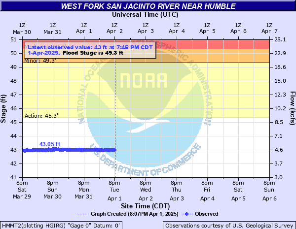
45.3' - Action
49.3' - Flood
50.3' - Moderate
52.3' - Major
Latest Observation
Updated: 6:09 PM LMT 12/31/00
Status: Obs Not Current
Stage: -999 ft
Flow: -999 kcfs
Forecast
Forecast not available for this location.
| Time | Stage (ft) | Flow (kcfs) |
|---|---|---|
| 2:45 PM 12/2 | 42.94 | 4.53 |
| 2:30 PM 12/2 | 42.94 | 4.53 |
| 2:15 PM 12/2 | 42.95 | 4.54 |
| 2:00 PM 12/2 | 42.95 | 4.54 |
| 1:45 PM 12/2 | 42.96 | 4.55 |
| 1:30 PM 12/2 | 42.97 | 4.56 |
| 1:15 PM 12/2 | 42.96 | 4.55 |
| 1:00 PM 12/2 | 42.97 | 4.56 |
| 12:45 PM 12/2 | 42.97 | 4.56 |
| 12:30 PM 12/2 | 42.96 | 4.55 |
| 12:15 PM 12/2 | 42.97 | 4.56 |
| 12:00 PM 12/2 | 42.98 | 4.57 |
| 11:45 AM 12/2 | 42.99 | 4.58 |
| 11:30 AM 12/2 | 42.99 | 4.58 |
| 11:15 AM 12/2 | 42.99 | 4.58 |
| 11:00 AM 12/2 | 43 | 4.59 |
| 10:45 AM 12/2 | 42.97 | 4.56 |
| 10:30 AM 12/2 | 43 | 4.59 |
| 10:15 AM 12/2 | 42.99 | 4.58 |
| 10:00 AM 12/2 | 42.98 | 4.57 |
| 9:45 AM 12/2 | 42.98 | 4.57 |
| 9:30 AM 12/2 | 42.97 | 4.56 |
| 9:15 AM 12/2 | 43 | 4.59 |
| 9:00 AM 12/2 | 43 | 4.59 |
| 8:45 AM 12/2 | 43.01 | 4.62 |
| 8:30 AM 12/2 | 43 | 4.59 |
| 8:15 AM 12/2 | 43.01 | 4.62 |
| 8:00 AM 12/2 | 43.02 | 4.65 |
| 7:45 AM 12/2 | 43.02 | 4.65 |
| 7:30 AM 12/2 | 43.03 | 4.69 |
55.2' -
Major lowland flooding continues with up to 6 inches of water is over the 800 block Hamblen Road adjacent to the Kingwood Cove Country Club Golf Course with many homes in the Bellau Woods and Treasure Cove subdivision are flooded.
54.4' -
Major lowland flooding continues with homes along Riverview Drive in River Ridge subdivision upstream of the gage begin to flood.
53.3' -
Major lowland flooding continues with water is in homes on Lake Lane West and Southshore Drive in the Bellau Woods subdivision and Homes in the Treasure Cove subdivision and along Aqua Vista Drive begin flooding.
52.3' -
Major lowland flooding begins as homes on Lake Lane West and Southshore Drive in the Belleau Woods subdivision begin flooding. Roads into the Treasure Cove subdivision are inundated and homes along Aqua Vista Drive threatened. Water is in many homes on Lake Point Drive in the Northshore subdivision.
51.5' -
Moderate lowland flooding continues with up to one foot of water is over the road at the intersection of Bellau Wodd and Riviera and many homes in the Northshore subdivision are cutoff.
50.3' -
Moderate lowland flooding begins as homes on Lake Point Drive in the Northshore subdivision begin flooding and roads in the Bellaeu Woods subdivision are cutoff.
49.3' -
Minor lowland flooding begins in the vicinity of the gage. North side turnaround at US 59 begins to flood. Low points on Thelma Road, Aqua Vista Drive, and Riverview Drive begin to flood.
| Date | Stage (ft) |
|---|---|
| Aug 29, 2017 | 69.18 |
| Oct 20, 1994 | 66.39 |
| May 31, 1929 | 63.23 |
| Nov 26, 1940 | 63.23 |
| May 29, 2016 | 61.95 |
| Nov 15, 1998 | 60.13 |
| May 4, 2024 | 58.8 |
| May 7, 1935 | 57.79 |
| Apr 21, 2016 | 57.32 |
| Nov 7, 2002 | 55.83 |
| Apr 19, 1979 | 55.7 |
| May 18, 1989 | 55.6 |
| Sep 19, 2019 | 55.41 |
| Jun 10, 2001 | 55.34 |
| Oct 20, 1998 | 55.08 |
| Dec 9, 1935 | 54.27 |
| Oct 19, 1998 | 54.16 |
| May 23, 1983 | 54 |
| Oct 29, 2002 | 53.93 |
| Sep 14, 2008 | 53.79 |
Data provided by the National Weather Service.