« Back to Saint Gertrude Rivers
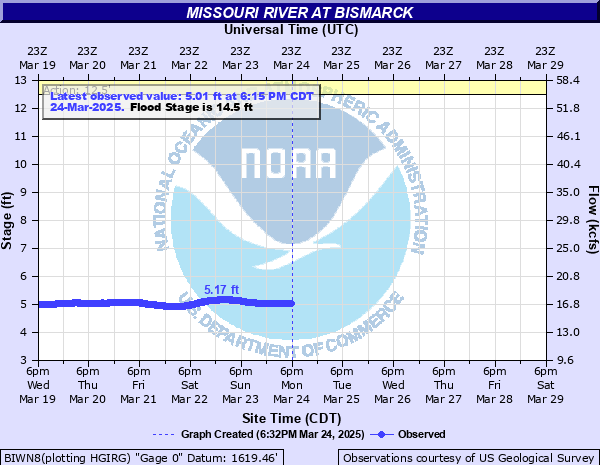
Missouri River at Bismarck
Critical Stages
12.5' - Action
14.5' - Flood
16' - Moderate
18' - Major
Latest Observation
Updated: 6:09 PM LMT 12/31/00
Status: Obs Not Current
Stage: -999 ft
Flow: -999 kcfs
Forecast
Forecast not available for this location.
| Time | Stage (ft) | Flow (kcfs) |
|---|---|---|
| 11:15 AM 12/12 | 4.9 | 17.6 |
| 11:00 AM 12/12 | 4.89 | 17.5 |
| 10:45 AM 12/12 | 4.87 | 17.5 |
| 10:30 AM 12/12 | 4.86 | 17.4 |
| 10:15 AM 12/12 | 4.84 | 17.3 |
| 10:00 AM 12/12 | 4.83 | 17.3 |
| 9:45 AM 12/12 | 4.81 | 17.2 |
| 9:30 AM 12/12 | 4.8 | 17.2 |
| 9:15 AM 12/12 | 4.78 | 17.1 |
| 9:00 AM 12/12 | 4.76 | 17 |
| 8:45 AM 12/12 | 4.76 | 17 |
| 8:30 AM 12/12 | 4.75 | 17 |
| 8:15 AM 12/12 | 4.75 | 17 |
| 8:00 AM 12/12 | 4.76 | 17 |
| 7:45 AM 12/12 | 4.76 | 17 |
| 7:30 AM 12/12 | 4.76 | 17 |
| 7:15 AM 12/12 | 4.76 | 17 |
| 7:00 AM 12/12 | 4.76 | 17 |
| 6:45 AM 12/12 | 4.76 | 17 |
| 6:30 AM 12/12 | 4.76 | 17 |
| 6:15 AM 12/12 | 4.76 | 17 |
| 6:00 AM 12/12 | 4.76 | 17 |
| 5:45 AM 12/12 | 4.76 | 17 |
| 5:30 AM 12/12 | 4.76 | 17 |
| 5:15 AM 12/12 | 4.76 | 17 |
| 5:00 AM 12/12 | 4.76 | 17 |
| 4:45 AM 12/12 | 4.75 | 17 |
| 4:30 AM 12/12 | 4.76 | 17 |
| 4:15 AM 12/12 | 4.76 | 17 |
| 4:00 AM 12/12 | 4.75 | 17 |
22' -
Significant number of homes and businesses on both sides of the river should be expected to flood if not protected.
20' -
Water begins to appear on the lowest stretches of River Road north of Bismarck.
18' -
Homes in the low-lying incorporated parts of Bismarck if not protected risk inundation.
17' -
City of Bismarck experiences flooding of streets in low-lying areas if not protected. Access to Fox Island and other rural developments becomes increasingly difficult. Access to homes in the Briardale, Hoge Island, Ponderosa, and Misty Waters developments north of Bismarck may be cutoff and some homes are taking on water if not protected.
16' -
Before 16 feet, older homes in the Fox Island area may experience flooding. Homes built to this level are at less risk but may have water surrounding them. Access to Fox island is difficult because of water on Riverwood Drive. No significant threat to the incorporated cities of Bismarck and Mandan.
14.5' -
Flooding of rural areas begins. Inundation of croplands and the potential closure of local boat ramp access is likely. Riverbank erosion rates increase and cause unstable shorelines. If water levels are the result of an icejam south of Bismarck, water levels will be relatively higher near the jam and cause concerns for residents south of Fox Island.
12.5' -
Unusually high river stage for this reach of the Missouri River. Residents are encouraged to pay close attention to NWS updates, local media, and local emergency management for information concerning why the river is this high and its potential for further rises.
| Date | Stage (ft) |
|---|---|
| Mar 31, 1881 | 31.6 |
| Jan 1, 1887 | 31.1 |
| Mar 14, 1910 | 30.4 |
| Apr 6, 1952 | 27.9 |
| Apr 8, 1897 | 27.7 |
| Apr 8, 1917 | 27.6 |
| Jan 1, 1884 | 27.4 |
| Apr 14, 1899 | 25.2 |
| Apr 7, 1913 | 22.6 |
| Mar 29, 1920 | 22.5 |
| Jan 1, 1894 | 22.2 |
| Mar 28, 1939 | 22.2 |
| Apr 3, 1943 | 21.86 |
| Mar 29, 1947 | 21.8 |
| Jan 1, 1883 | 21.6 |
| Apr 6, 1912 | 21.2 |
| Jan 1, 1888 | 20.9 |
| Apr 5, 1919 | 19.6 |
| Mar 19, 1938 | 19.6 |
| Mar 20, 1916 | 19.3 |
Data provided by the National Weather Service.