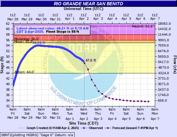
Rio Grande near San Benito
Critical Stages
44' - Action
55' - Flood
56' - Moderate
58' - Major
Latest Observation
Updated: 2:15 PM CST 12/15/25
Status: No Flooding
Stage: 34.72 ft
Flow: 0.238 kcfs
Forecast
| Time | Stage (ft) | Flow (kcfs) |
|---|---|---|
| 6 PM 12/15 | 35 | 0.363 |
| 12 AM 12/16 | 35 | 0.363 |
| 6 AM 12/16 | 35 | 0.363 |
| 12 PM 12/16 | 35 | 0.363 |
| 6 PM 12/16 | 35 | 0.363 |
| 12 AM 12/17 | 35 | 0.363 |
| 6 AM 12/17 | 34.9 | 0.313 |
| 12 PM 12/17 | 34.9 | 0.313 |
| 6 PM 12/17 | 34.9 | 0.313 |
| 12 AM 12/18 | 34.9 | 0.313 |
| 6 AM 12/18 | 34.9 | 0.313 |
| 12 PM 12/18 | 34.9 | 0.313 |
| 6 PM 12/18 | 34.9 | 0.313 |
| 12 AM 12/19 | 34.9 | 0.313 |
| 6 AM 12/19 | 34.9 | 0.313 |
| 12 PM 12/19 | 34.9 | 0.313 |
| 6 PM 12/19 | 34.8 | 0.27 |
| 12 AM 12/20 | 34.8 | 0.27 |
| 6 AM 12/20 | 34.8 | 0.27 |
| Time | Stage (ft) | Flow (kcfs) |
|---|---|---|
| 2:15 PM 12/15 | 34.72 | 0.238 |
| 2:00 PM 12/15 | 34.73 | 0.241 |
| 1:45 PM 12/15 | 34.73 | 0.241 |
| 1:30 PM 12/15 | 34.74 | 0.245 |
| 1:15 PM 12/15 | 34.75 | 0.249 |
| 1:00 PM 12/15 | 34.76 | 0.253 |
| 12:45 PM 12/15 | 34.76 | 0.253 |
| 12:30 PM 12/15 | 34.77 | 0.257 |
| 12:15 PM 12/15 | 34.78 | 0.261 |
| 12:00 PM 12/15 | 34.79 | 0.266 |
| 11:45 AM 12/15 | 34.79 | 0.266 |
| 11:30 AM 12/15 | 34.79 | 0.266 |
| 11:15 AM 12/15 | 34.8 | 0.27 |
| 11:00 AM 12/15 | 34.81 | 0.274 |
| 10:45 AM 12/15 | 34.82 | 0.278 |
| 10:30 AM 12/15 | 34.82 | 0.278 |
| 10:15 AM 12/15 | 34.83 | 0.282 |
| 10:00 AM 12/15 | 34.84 | 0.286 |
| 9:45 AM 12/15 | 34.84 | 0.286 |
| 9:30 AM 12/15 | 34.85 | 0.291 |
| 9:15 AM 12/15 | 34.85 | 0.291 |
| 9:00 AM 12/15 | 34.85 | 0.291 |
| 8:45 AM 12/15 | 34.86 | 0.295 |
| 8:30 AM 12/15 | 34.86 | 0.295 |
| 8:15 AM 12/15 | 34.86 | 0.295 |
| 8:00 AM 12/15 | 34.86 | 0.295 |
| 7:45 AM 12/15 | 34.86 | 0.295 |
| 7:30 AM 12/15 | 34.86 | 0.295 |
| 7:15 AM 12/15 | 34.86 | 0.295 |
| 7:00 AM 12/15 | 34.85 | 0.291 |
70' -
The river exceeds the levees - flooding is widespread, disastrous, and life threatening -
65' -
The river is approaching the top of the levees - residents should be prepared to evacaute rapidly to several tens of miles from the lower Rio Grande channel as emergency officials direct - persons in the flood plain should monitor the latest stage and forecast levels of the river continuously.
58' -
Major flooding covers the flood plain inside the levees-threatens lowest residences in Brownsville and Matamoros - persons vulnerable to lowland flooding should move equipment to higher ground and monitor the level of the river especially if heavy rain conditions develop.
56' -
Moderate lowland flooding inside the levees reaches lowest secondary roads and low bridges
55' -
Minor lowland flooding reaches into the lowest sections of the flood plain inside the levees with no significant damage
44' -
The river will exceed the lowest banks of the lowest sections inside the levees
| Date | Stage (ft) |
|---|---|
| Sep 29, 1967 | 61.06 |
| Oct 4, 1988 | 55.98 |
| Sep 28, 1988 | 55.18 |
| Jun 2, 1992 | 54.85 |
| Jul 30, 2020 | 54.82 |
| Sep 13, 2010 | 54.41 |
| Mar 30, 2025 | 54.04 |
| Jul 21, 2010 | 53.63 |
| Jun 4, 2015 | 53.44 |
| Sep 28, 2010 | 53.06 |
| Jul 12, 2010 | 52.64 |
| Jun 24, 1993 | 51.94 |
| Jun 24, 2018 | 51.6 |
| Oct 14, 2008 | 50.84 |
| May 16, 1991 | 47.31 |
| Sep 14, 1987 | 47.28 |
| May 12, 1993 | 45.54 |
| May 27, 2022 | 45.42 |
| Oct 10, 1987 | 44.58 |
| May 2, 1989 | 43.67 |
Data provided by the National Weather Service.