Seco Creek at Rowe Ranch near D'Hanis
Critical Stages
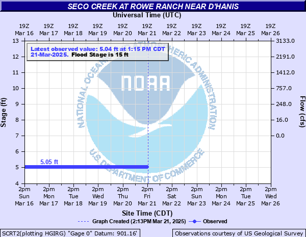
13' - Action
15' - Flood
19' - Moderate
23' - Major
Latest Observation
Updated: 7:15 PM CST 12/7/25
Status: No Flooding
Stage: 5.04 ft
Flow: -999 kcfs
Forecast
Forecast not available for this location.
| Time | Stage (ft) | Flow (kcfs) |
|---|---|---|
| 7:15 PM 12/7 | 5.04 | -999 |
| 7:00 PM 12/7 | 5.04 | -999 |
| 6:45 PM 12/7 | 5.04 | -999 |
| 6:30 PM 12/7 | 5.04 | -999 |
| 6:15 PM 12/7 | 5.04 | -999 |
| 6:00 PM 12/7 | 5.05 | -999 |
| 5:45 PM 12/7 | 5.04 | -999 |
| 5:30 PM 12/7 | 5.04 | -999 |
| 5:15 PM 12/7 | 5.04 | -999 |
| 5:00 PM 12/7 | 5.05 | -999 |
| 4:45 PM 12/7 | 5.04 | -999 |
| 4:30 PM 12/7 | 5.05 | -999 |
| 4:15 PM 12/7 | 5.05 | -999 |
| 4:00 PM 12/7 | 5.04 | -999 |
| 3:45 PM 12/7 | 5.05 | -999 |
| 3:30 PM 12/7 | 5.05 | -999 |
| 3:15 PM 12/7 | 5.05 | -999 |
| 3:00 PM 12/7 | 5.05 | -999 |
| 2:45 PM 12/7 | 5.04 | -999 |
| 2:30 PM 12/7 | 5.05 | -999 |
| 2:15 PM 12/7 | 5.05 | -999 |
| 2:00 PM 12/7 | 5.05 | -999 |
| 1:45 PM 12/7 | 5.05 | -999 |
| 1:30 PM 12/7 | 5.05 | -999 |
| 1:15 PM 12/7 | 5.05 | -999 |
| 1:00 PM 12/7 | 5.04 | -999 |
| 12:45 PM 12/7 | 5.05 | -999 |
| 12:30 PM 12/7 | 5.05 | -999 |
| 12:15 PM 12/7 | 5.05 | -999 |
| 12:00 PM 12/7 | 5.05 | -999 |
32' -
Life threatening massive flooding occurs in all of D'Hanis. Flow is several feet deep down Main Street and businesses have several feet of water. Some homes in the western part have nine feet of water in them. Miles of Highway 90 flood with major damage.
28' -
All homes west of the brick plant in D'Hanis flood due to Seco Creek alone, with up to five feet of water. If Seco and Parker Creeks are flooding, all of D'Hanis is under several feet of water with up to six feet in lowest homes. This is a life threatening event.
24' -
Seco Creek alone (without Parker Creek) floods the lowest homes in D'Hanis. Nearly a mile of Highway 90 is flooded with significant damage. If Seco and Parker Creeks are seriously flooding, all of D'Hanis is under water.
23' -
Major flooding causes Seco Creek alone (without Parker Creek) to approach homes in D'Hanis. If Parker and Seco Creeks are flooding, all of D'Hanis may be under water and several feet deep in homes in the west part. Highway 90 is severly flooded.
19' -
Moderate lowland flooding impacts secondary roads and low bridges making them dangerous to auto traffic. Livestock should be moved from low areas of the flood plain. Lowest homes in D'Hanis are threatened.
15' -
Minor lowland flooding reaches lowest areas of the flood plain with no significant damage.
| Date | Stage (ft) |
|---|---|
| May 31, 1935 | 35.7 |
| Aug 31, 1994 | 33 |
| Jun 17, 1958 | 32.4 |
| Jul 21, 2007 | 32.35 |
| Jun 22, 1997 | 30.62 |
| Jul 2, 1932 | 28.2 |
| May 29, 1987 | 28.2 |
| Sep 1, 1919 | 28 |
| Jul 15, 1973 | 26 |
| Jun 3, 1987 | 23.55 |
| Aug 23, 1998 | 20 |
| Jul 5, 2002 | 19.13 |
| May 29, 2016 | 17.1 |
Data provided by the National Weather Service.