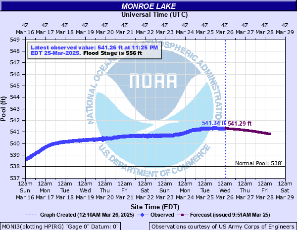
Salt Creek (IN) at Monroe Lake
Critical Stages
556' - Action
556' - Flood
556' - Moderate
556' - Major
Latest Observation
Updated: 1:25 PM EST 12/6/25
Status: No Flooding
Stage: 537.87 ft
Flow: -999 kcfs
Forecast
Forecast not available for this location.
| Time | Stage (ft) | Flow (kcfs) |
|---|---|---|
| 2:25 PM 12/6 | 537.88 | -999 |
| 2:20 PM 12/6 | 537.88 | -999 |
| 2:15 PM 12/6 | 537.89 | -999 |
| 2:10 PM 12/6 | 537.89 | -999 |
| 2:05 PM 12/6 | 537.88 | -999 |
| 2:00 PM 12/6 | 537.89 | -999 |
| 1:55 PM 12/6 | 537.89 | -999 |
| 1:50 PM 12/6 | 537.9 | -999 |
| 1:45 PM 12/6 | 537.88 | -999 |
| 1:40 PM 12/6 | 537.89 | -999 |
| 1:35 PM 12/6 | 537.89 | -999 |
| 1:30 PM 12/6 | 537.88 | -999 |
| 1:25 PM 12/6 | 537.87 | -999 |
| 1:20 PM 12/6 | 537.89 | -999 |
| 1:15 PM 12/6 | 537.87 | -999 |
| 1:10 PM 12/6 | 537.89 | -999 |
| 1:05 PM 12/6 | 537.88 | -999 |
| 1:00 PM 12/6 | 537.88 | -999 |
| 12:55 PM 12/6 | 537.88 | -999 |
| 12:50 PM 12/6 | 537.88 | -999 |
| 12:45 PM 12/6 | 537.89 | -999 |
| 12:40 PM 12/6 | 537.89 | -999 |
| 12:35 PM 12/6 | 537.88 | -999 |
| 12:30 PM 12/6 | 537.88 | -999 |
| 12:25 PM 12/6 | 537.89 | -999 |
| 12:20 PM 12/6 | 537.89 | -999 |
| 12:15 PM 12/6 | 537.88 | -999 |
| 12:10 PM 12/6 | 537.88 | -999 |
| 12:05 PM 12/6 | 537.88 | -999 |
| 12:00 PM 12/6 | 537.88 | -999 |
574' -
Top of Dam.
566' -
Top of Stored Emergency Gage.
556.7' -
On May 3, 2011 WISH-TV toured the the lake and found submerged beaches, parking lot, hiking paths and boat slips nearly inaccessible. At the Four Winds Resort walkways were flooded and only the roof of the wedding tiki hut above water.
556.6' -
Valley Mission Road is closed at this level or slightly higher because of water going through the emergency spillway.
556' -
Flood Pool Elevation. South Dam access road closed. North Fork of Cleve Butcher Road floods. Flood Pool covers 18,450 acres and stretchs for 44 miles. There is a 3.3 0x0p+0nnual chance of occurrence of this level.
555' -
Lake Monroe Sailing Association, visitor parking lot, service road to Area D, campsites in Area B, Area C and Area H at Paynetown flooded. Brummett Creek Road and Old State Road 46 begin to flood. Brummett Creek Road often flooded by Salt Creek and not the dam. There is a 6.7 0x0p+0nnual chance of occurrence of this level.
554' -
Playground at Paynetown campground flooded. There is a 10 0x0p+0nnual chance of occurrence of this level.
553.25' -
Four campsites in Area A of Paynetown Campground flooded. Boom for multi-level jib crane under water.
552' -
Brummett Creek Road flooded. Pit toilet flooded in Paynetown Campground.
551.7' -
Allen's Creek SRA Road floods. Approach road to Hardin Ridge Beach closed. IDNR storage building at Crooked Creek, boat storage at Lake Monroe Sailing Association, Pine Grove ramp access road and Crooked Creek ramp flooded. Cutright highwater gravel access ramp begins to flood. There is about a 20 0x0p+0nnual chance of occurrence of this level. Public report on April 6, 2018 indicated this road was open at 550.7 feet and estimated the road would flood near 552 feet rather than at 550 feet.
551.5' -
Cutright access road goes underwater near the main boat ramp. Access to ramp, picnic areas and Pleasure Craft Marina is unavailable by vehicle.
551' -
Lower end of Moore's Creek Road flooded.
549' -
North fork of Cleve Butcher Road flooded.
548' -
Approach road to Paynetown docks flooded.
547' -
Emergency bypass bulkhead under water.
546' -
Fairfax, Paynetown and Cutright ramps flooded.
545' -
Fairfax and Hardin Ridge beaches closed. There is a 50 0x0p+0nnual chance of occurrence of this level.
544' -
Friendship, Stipp, and upper end of Moores Creek roads closed.
543' -
Paynetown beach and McGowan road to Northfork flooded. Water covers back platform of tower including emergency gate and bypass bulkhead slots. There is a 100 0x0p+0nnual chance of occurrence of this level.
541' -
Drainage for marshes stopped. Many crop lease fields flooded.
540' -
Lake Monroe Sailing Association jib cranes flooded.
538' -
Year Round Pool Elevation. Normal Pool covers 10,750 acres and stretches for 37 miles.
537' -
Courtesy Dock adjusted.
536' -
Crooked Creek ramp closed.
535' -
Upper end of lake and east of causeway difficult to use.
| Date | Stage (ft) |
|---|---|
| May 4, 2011 | 557.28 |
| May 15, 2002 | 556.25 |
| Apr 13, 2008 | 555.03 |
| May 16, 1996 | 554.95 |
| Feb 26, 2019 | 553.1 |
| Jun 30, 2019 | 552.83 |
| May 17, 1983 | 551.55 |
| Jan 18, 2005 | 551.39 |
| Jun 25, 1998 | 551.27 |
| Jan 24, 2007 | 551.1 |
| Apr 16, 2018 | 551.01 |
| May 2, 1973 | 550.6 |
| Jun 4, 1995 | 549.92 |
| Apr 10, 1989 | 549.76 |
| Jul 26, 2015 | 549.57 |
| Apr 2, 1975 | 549.3 |
| Dec 14, 1985 | 549.2 |
| Mar 25, 1982 | 549.1 |
| Feb 10, 1969 | 548.6 |
| Apr 19, 1979 | 548.6 |
Data provided by the National Weather Service.