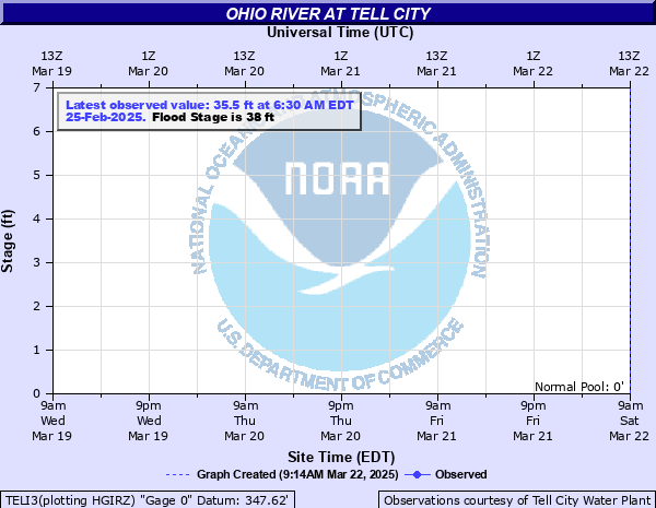
Ohio River at Tell City
Critical Stages
36' - Action
38' - Flood
44' - Moderate
50' - Major
Latest Observation
Updated: 7:03 PM LMT 12/31/00
Status: Obs Not Current
Stage: -999 ft
Flow: -999 kcfs
Forecast
Forecast not available for this location.
Observation history not available.
60.5' -
Water reaches top of floodwall in Tell City Indiana and Hawesville Kentucky.
60' -
Water reaches top of floodwall in Cannelton Indiana.
57' -
Almost all businesses and one quarter of homes in Tell City flood.
48' -
Water reaches railroad tracks and starts up Main St. in Tell City.
46.5' -
Flood gates in Hawesville KY close.
44' -
Bottomland on both sides floods. Water reaches base of floodwall.
40' -
Indiana highway 66 closes above Cannelton.
38' -
Indiana highway 66 floods between Derby and Magnet...Rome and Derby...and at Rocky Point.
35.5' -
Floodgates begin closing.
| Date | Stage (ft) |
|---|---|
| Jan 29, 1937 | 56.95 |
| Mar 8, 1964 | 53 |
| Mar 10, 1945 | 52 |
| Feb 15, 1884 | 50.8 |
| Apr 1, 1913 | 50.7 |
| Mar 8, 1997 | 50.4 |
| Apr 10, 2025 | 49.5 |
| Feb 27, 2018 | 49.3 |
| Apr 20, 1948 | 49 |
| Apr 28, 2011 | 48 |
| Mar 6, 1962 | 47.8 |
| Mar 24, 1943 | 47.5 |
| Mar 12, 1955 | 47.1 |
| Feb 9, 1950 | 47 |
| Mar 20, 1963 | 46.9 |
| May 12, 1961 | 46.8 |
| Feb 11, 1939 | 46.2 |
| Mar 17, 2015 | 46.1 |
| Feb 5, 1952 | 45.6 |
| Apr 27, 1940 | 45.5 |
Data provided by the National Weather Service.