Roanoke River at Roanoke Rapids
Critical Stages
9' - Action
9' - Flood
12' - Moderate
15' - Major
Latest Observation
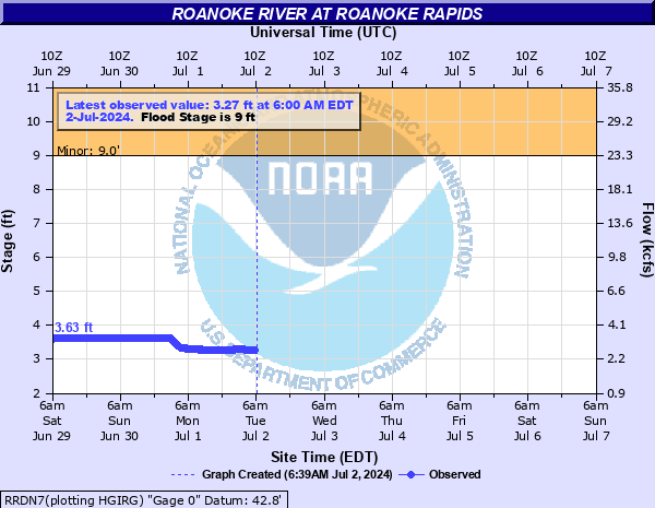
Updated: 9:30 AM EST 12/16/25
Status: No Flooding
Stage: 5.68 ft
Flow: 8.43 kcfs
Forecast
Forecast not available for this location.
| Time | Stage (ft) | Flow (kcfs) |
|---|---|---|
| 9:45 AM 12/16 | 5.28 | 7.14 |
| 9:30 AM 12/16 | 5.68 | 8.43 |
| 9:15 AM 12/16 | 6.14 | 10.1 |
| 9:00 AM 12/16 | 6.34 | 10.8 |
| 8:45 AM 12/16 | 6.34 | 10.8 |
| 8:30 AM 12/16 | 6.34 | 10.8 |
| 8:15 AM 12/16 | 6.34 | 10.8 |
| 8:00 AM 12/16 | 6.34 | 10.8 |
| 7:45 AM 12/16 | 6.33 | 10.8 |
| 7:30 AM 12/16 | 6.32 | 10.7 |
| 7:15 AM 12/16 | 6.32 | 10.7 |
| 7:00 AM 12/16 | 6.31 | 10.7 |
| 6:45 AM 12/16 | 6.31 | 10.7 |
| 6:30 AM 12/16 | 6.29 | 10.6 |
| 6:15 AM 12/16 | 6.26 | 10.5 |
| 6:00 AM 12/16 | 6.22 | 10.4 |
| 5:45 AM 12/16 | 6.17 | 10.2 |
| 5:30 AM 12/16 | 6.08 | 9.84 |
| 5:15 AM 12/16 | 5.94 | 9.33 |
| 5:00 AM 12/16 | 5.72 | 8.56 |
| 4:45 AM 12/16 | 5.37 | 7.42 |
| 4:30 AM 12/16 | 4.84 | 5.87 |
| 4:15 AM 12/16 | 4.2 | 4.29 |
| 4:00 AM 12/16 | 4.05 | 3.95 |
| 3:45 AM 12/16 | 4.05 | 3.95 |
| 3:30 AM 12/16 | 4.05 | 3.95 |
| 3:15 AM 12/16 | 4.05 | 3.95 |
| 3:00 AM 12/16 | 4.05 | 3.95 |
| 2:45 AM 12/16 | 4.05 | 3.95 |
| 2:30 AM 12/16 | 4.05 | 3.95 |
15' -
Major flooding begins. There is significant flooding of homes and businesses in Roanoke Rapids.
13' -
Moderate flooding begins. Homes and other structures along the river in Roanoke Rapids flood.
10' -
The public boat ramp on Rockfish Ln in Weldon is flooded.
9' -
Minor flooding begins. Farmlands and timberlands adjacent to the river in Roanoke Rapids flood. Property on the farmlands may be at risk from floodwaters.
| Date | Stage (ft) |
|---|---|
| Aug 18, 1940 | 39 |
| Sep 22, 1944 | 26.95 |
| Sep 22, 1945 | 26.78 |
| Feb 17, 1948 | 19.25 |
| Dec 7, 1948 | 18.99 |
| May 7, 1958 | 16.52 |
| Nov 2, 1949 | 16.04 |
| Sep 26, 1947 | 15.48 |
| Aug 19, 1955 | 12.83 |
| Apr 16, 1993 | 11.87 |
| Nov 20, 2018 | 11.77 |
| Apr 25, 1987 | 11.69 |
| Sep 12, 1996 | 11.6 |
| Apr 13, 1975 | 11.59 |
| Feb 25, 2021 | 10.94 |
| Oct 24, 2018 | 10.93 |
| Jun 20, 1989 | 10.23 |
| Oct 3, 2018 | 10.11 |
| Oct 10, 1979 | 9.75 |
| Mar 6, 1984 | 9.6 |
Data provided by the National Weather Service.