« Back to Sheridan Lake Rivers
Arkansas River at Lamar
Critical Stages
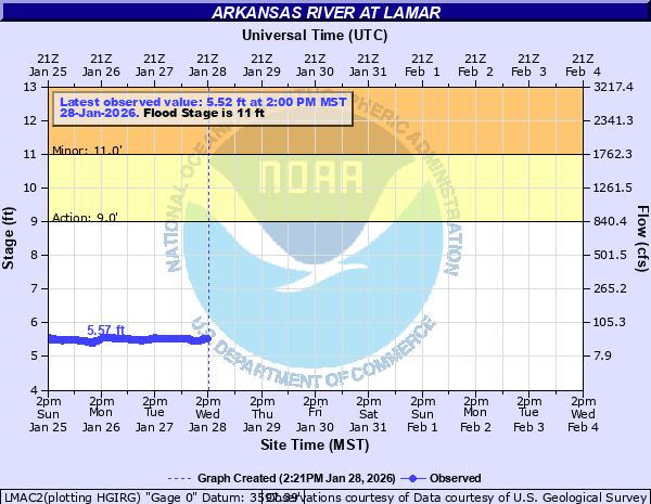
9' - Action
11' - Flood
13' - Moderate
15' - Major
Latest Observation
Updated: 1:00 AM MST 12/16/25
Status: No Flooding
Stage: 5.54 ft
Flow: 0.0403 kcfs
Forecast
Forecast not available for this location.
| Time | Stage (ft) | Flow (kcfs) |
|---|---|---|
| 1:00 AM 12/16 | 5.54 | 0.0403 |
| 12:45 AM 12/16 | 5.54 | 0.0403 |
| 12:30 AM 12/16 | 5.54 | 0.0403 |
| 12:15 AM 12/16 | 5.54 | 0.0403 |
| 12:00 AM 12/16 | 5.54 | 0.0403 |
| 11:45 PM 12/15 | 5.54 | 0.0403 |
| 11:30 PM 12/15 | 5.54 | 0.0403 |
| 11:15 PM 12/15 | 5.55 | 0.0415 |
| 11:00 PM 12/15 | 5.54 | 0.0403 |
| 10:45 PM 12/15 | 5.54 | 0.0403 |
| 10:30 PM 12/15 | 5.54 | 0.0403 |
| 10:15 PM 12/15 | 5.54 | 0.0403 |
| 10:00 PM 12/15 | 5.55 | 0.0415 |
| 9:45 PM 12/15 | 5.54 | 0.0403 |
| 9:30 PM 12/15 | 5.54 | 0.0403 |
| 9:15 PM 12/15 | 5.54 | 0.0403 |
| 9:00 PM 12/15 | 5.54 | 0.0403 |
| 8:45 PM 12/15 | 5.54 | 0.0403 |
| 8:30 PM 12/15 | 5.54 | 0.0403 |
| 8:15 PM 12/15 | 5.54 | 0.0403 |
| 8:00 PM 12/15 | 5.54 | 0.0403 |
| 7:45 PM 12/15 | 5.55 | 0.0415 |
| 7:30 PM 12/15 | 5.54 | 0.0403 |
| 7:15 PM 12/15 | 5.55 | 0.0415 |
| 7:00 PM 12/15 | 5.55 | 0.0415 |
| 6:45 PM 12/15 | 5.55 | 0.0415 |
| 6:30 PM 12/15 | 5.55 | 0.0415 |
| 6:15 PM 12/15 | 5.55 | 0.0415 |
| 6:00 PM 12/15 | 5.55 | 0.0415 |
| 5:45 PM 12/15 | 5.55 | 0.0415 |
25' -
Major flooding occurs in Lamar. Multiple homes and businesses are impacted. Water reaches the base of the Highway 287 Bridge.
19' -
Flood waters inundate the industrial park on the north side of Lamar. Multiple businesses are impacted. Flood waters threaten The Days Inn, The Cow Palace, Ranchers Supply Company and Opals Pub. Gravel and paving operations and North Gateway Park near the Highway 287 Bridge are inundated.
18' -
Flood waters threaten the All Rite Paving and Redi Mix operation on the northwest side of the Highway 287 Bridge.
17' -
Flood waters reach the parking areas near the Ace Tire operation on the northeast side of the Highway 287 Bridge.
15' -
Major agricultural flooding occurs. Lowlands are completely inundated. Waters begin to threaten North Gateway Park southeast of the Highway 50 bridge.
13' -
Moderate lowland agricultural flooding occurs near Lamar.
11' -
Minor lowland agricultural flooding occurs near Lamar.
10' -
The river is bankfull. Minor overbank flow into lowlands along the river occurs near Lamar. Water flows into low lying meadows near County Road 13.
9' -
Minor overbank flow into low spots along the river occurs near Lamar.
| Date | Stage (ft) |
|---|---|
| May 27, 1996 | 13.06 |
| Aug 12, 1997 | 12.79 |
| Jul 31, 1998 | 12.47 |
| Jul 30, 2014 | 11.41 |
| Jul 22, 2023 | 11.13 |
| Jun 7, 1999 | 11.11 |
| Jun 4, 1995 | 11.09 |
| Jul 27, 2009 | 11.01 |
| Jul 26, 2018 | 11.01 |
| May 25, 1987 | 10.74 |
| Jun 8, 2001 | 10.63 |
| Aug 14, 1994 | 10.02 |
| Aug 29, 2002 | 9.29 |
| Jul 21, 1992 | 8.95 |
| Sep 15, 1988 | 8.82 |
Data provided by the National Weather Service.