« Back to Sheridan Lake Rivers
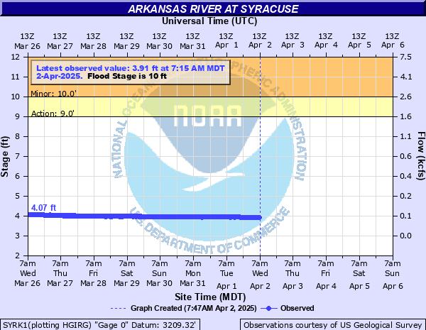
Arkansas River at Syracuse
Critical Stages
9' - Action
10' - Flood
12' - Moderate
14' - Major
Latest Observation
Updated: 12:15 AM MST 12/16/25
Status: No Flooding
Stage: 4.09 ft
Flow: 0.0678 kcfs
Forecast
Forecast not available for this location.
| Time | Stage (ft) | Flow (kcfs) |
|---|---|---|
| 12:15 AM 12/16 | 4.09 | 0.0678 |
| 12:00 AM 12/16 | 4.09 | 0.0678 |
| 11:45 PM 12/15 | 4.08 | 0.0668 |
| 11:30 PM 12/15 | 4.08 | 0.0668 |
| 11:15 PM 12/15 | 4.08 | 0.0668 |
| 11:00 PM 12/15 | 4.08 | 0.0668 |
| 10:45 PM 12/15 | 4.08 | 0.0668 |
| 10:30 PM 12/15 | 4.08 | 0.0668 |
| 10:15 PM 12/15 | 4.08 | 0.0668 |
| 10:00 PM 12/15 | 4.08 | 0.0668 |
| 9:45 PM 12/15 | 4.08 | 0.0668 |
| 9:30 PM 12/15 | 4.1 | 0.0688 |
| 9:15 PM 12/15 | 4.09 | 0.0678 |
| 9:00 PM 12/15 | 4.09 | 0.0678 |
| 8:45 PM 12/15 | 4.1 | 0.0688 |
| 8:30 PM 12/15 | 4.1 | 0.0688 |
| 8:15 PM 12/15 | 4.1 | 0.0688 |
| 8:00 PM 12/15 | 4.09 | 0.0678 |
| 7:45 PM 12/15 | 4.09 | 0.0678 |
| 7:30 PM 12/15 | 4.1 | 0.0688 |
| 7:15 PM 12/15 | 4.09 | 0.0678 |
| 7:00 PM 12/15 | 4.09 | 0.0678 |
| 6:45 PM 12/15 | 4.09 | 0.0678 |
| 6:30 PM 12/15 | 4.09 | 0.0678 |
| 6:15 PM 12/15 | 4.08 | 0.0668 |
| 6:00 PM 12/15 | 4.08 | 0.0668 |
| 5:45 PM 12/15 | 4.08 | 0.0668 |
| 5:30 PM 12/15 | 4.09 | 0.0678 |
| 7:15 PM 12/14 | 4.09 | 0.0678 |
| 7:00 PM 12/14 | 4.08 | 0.0668 |
18.1' -
At 18.1 feet, the water surface elevation will reach the lowest points of the Kansas K-27 highway bridge steel.
18' -
Expect extremely severe flooding along the Arkansas River from Syracuse to Kendall. Flood depths of 8 feet or more will occur as the river moves well out onto the floodplain. The golf course and fairground at Syracuse will be inundated... 2 feet or so at the fairgrounds... 6 feet or so at the park. Flooding will extend into housing areas in southern parts of Syracuse and Kendall.
13' -
Expect moderate flooding along the Arkansas River from Syracuse to Kendall. The river road running parallel south of the river will be inundated to depths of 2 feet in some places. Floodwaters will begin to encroach upon the fairgrounds and golf course at Syracuse.
10' -
Expect minor flooding of 1 foot or so along the Arkansas River from Syracuse to Kendall.
| Date | Stage (ft) |
|---|---|
| Jun 17, 1965 | 21.8 |
| May 15, 1951 | 15.63 |
| Jun 5, 1949 | 14.2 |
| Apr 27, 1942 | 13.46 |
| May 31, 1964 | 13.3 |
| May 29, 1957 | 12.189999580383 |
| May 31, 1936 | 11.58 |
| Aug 8, 1929 | 11.04 |
| Aug 9, 1936 | 11.01 |
| May 20, 1955 | 10.9 |
| Aug 23, 1923 | 10.8 |
| Jul 31, 1936 | 10.72 |
| Sep 8, 1937 | 10.68 |
| Sep 5, 1938 | 10.55 |
| Jul 14, 1927 | 10.5 |
| May 4, 1941 | 10.44 |
| Jun 18, 1923 | 10.4 |
| Jul 12, 1935 | 10.38 |
| Aug 7, 1954 | 10.32 |
| May 28, 1935 | 10.3 |
Data provided by the National Weather Service.