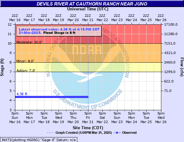
Devils River at Cauthorn Ranch near Juno
Critical Stages
7' - Action
8' - Flood
10' - Moderate
18' - Major
Latest Observation
Updated: 7:15 PM CST 12/15/25
Status: No Flooding
Stage: 4.39 ft
Flow: -999 kcfs
Forecast
Forecast not available for this location.
| Time | Stage (ft) | Flow (kcfs) |
|---|---|---|
| 8:15 PM 12/15 | 4.39 | -999 |
| 8:00 PM 12/15 | 4.39 | -999 |
| 7:45 PM 12/15 | 4.39 | -999 |
| 7:30 PM 12/15 | 4.39 | -999 |
| 7:15 PM 12/15 | 4.39 | -999 |
| 7:00 PM 12/15 | 4.39 | -999 |
| 6:45 PM 12/15 | 4.39 | -999 |
| 6:30 PM 12/15 | 4.39 | -999 |
| 6:15 PM 12/15 | 4.39 | -999 |
| 6:00 PM 12/15 | 4.39 | -999 |
| 5:45 PM 12/15 | 4.39 | -999 |
| 5:30 PM 12/15 | 4.39 | -999 |
| 5:15 PM 12/15 | 4.39 | -999 |
| 5:00 PM 12/15 | 4.39 | -999 |
| 4:45 PM 12/15 | 4.39 | -999 |
| 4:30 PM 12/15 | 4.39 | -999 |
| 4:15 PM 12/15 | 4.39 | -999 |
| 4:00 PM 12/15 | 4.39 | -999 |
| 3:45 PM 12/15 | 4.39 | -999 |
| 3:30 PM 12/15 | 4.39 | -999 |
| 3:15 PM 12/15 | 4.39 | -999 |
| 3:00 PM 12/15 | 4.39 | -999 |
| 2:45 PM 12/15 | 4.39 | -999 |
| 2:30 PM 12/15 | 4.39 | -999 |
| 2:15 PM 12/15 | 4.39 | -999 |
| 2:00 PM 12/15 | 4.39 | -999 |
| 1:45 PM 12/15 | 4.39 | -999 |
| 1:30 PM 12/15 | 4.39 | -999 |
| 1:15 PM 12/15 | 4.39 | -999 |
| 1:00 PM 12/15 | 4.39 | -999 |
18' -
(5.5 meters), Major lowland flooding above Ozona to Amistad Reservoir floods.
16' -
(4.9 meters), Flow is well into the flood plain and life threatening to campers near the river from the headwaters to Amistad Reservoir. Low roads and crossings are extremely dangerous along the Devils River and tributaries. Livestock should be removed from the flood plain.
13' -
(4.0 meters), Campers, autos and gear on the banks wash downstream as this flood wave moves downstream.
10' -
(3.0 meters), Numerous portions of Highway 163 along the Devils River become flooded. Low water crossings and bridges along the Devils River are impassable, and motorists may become stranded between low spots for several hours.
8' -
(2.4 meters), Several low crossings on Highway 163 on the Devils River are flooded, and motorists may become stranded between crossings for several hours.
7' -
(2.1 meters), Low water crossings on the Devils River become impassable, and motorists will have a risk of becoming stranded between crossings.
6' -
(1.8 meters), Water begins to run over the road at many Hwy 163 low crossings.
| Date | Stage (ft) |
|---|---|
| Oct 18, 2018 | 15.09 |
| Sep 22, 2018 | 13.71 |
| Nov 17, 2004 | 10.38 |
| Jun 28, 2016 | 9.11 |
Data provided by the National Weather Service.