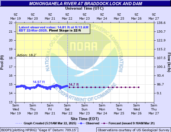
Monongahela River at Braddock Lock and Dam
Critical Stages
18.2' - Action
22' - Flood
23' - Moderate
24' - Major
Latest Observation
Updated: 10:58 AM EST 12/6/25
Status: No Flooding
Stage: 14.7 ft
Flow: 0.673 kcfs
Forecast
| Time | Stage (ft) | Flow (kcfs) |
|---|---|---|
| 1 PM 12/6 | 14.7 | 0.673 |
| 7 PM 12/6 | 14.7 | 0.673 |
| 1 AM 12/7 | 14.6 | 0.515 |
| 7 AM 12/7 | 14.6 | 0.515 |
| 1 PM 12/7 | 14.6 | 0.515 |
| 7 PM 12/7 | 14.6 | 0.515 |
| 1 AM 12/8 | 14.6 | 0.515 |
| 7 AM 12/8 | 14.6 | 0.515 |
| 1 PM 12/8 | 14.6 | 0.515 |
| 7 PM 12/8 | 14.6 | 0.515 |
| 1 AM 12/9 | 14.6 | 0.515 |
| 7 AM 12/9 | 14.6 | 0.515 |
| 1 PM 12/9 | 14.6 | 0.515 |
| 7 PM 12/9 | 14.6 | 0.515 |
| 1 AM 12/10 | 14.6 | 0.515 |
| 7 AM 12/10 | 14.6 | 0.515 |
| 1 PM 12/10 | 14.6 | 0.515 |
| 7 PM 12/10 | 14.6 | 0.515 |
| 1 AM 12/11 | 14.6 | 0.515 |
| 7 AM 12/11 | 14.6 | 0.515 |
| Time | Stage (ft) | Flow (kcfs) |
|---|---|---|
| 11:13 AM 12/6 | 14.63 | 0.558 |
| 10:58 AM 12/6 | 14.7 | 0.673 |
| 10:43 AM 12/6 | 14.68 | 0.638 |
| 10:28 AM 12/6 | 14.68 | 0.638 |
| 10:13 AM 12/6 | 14.7 | 0.673 |
| 9:58 AM 12/6 | 14.68 | 0.638 |
| 9:43 AM 12/6 | 14.69 | 0.655 |
| 9:28 AM 12/6 | 14.68 | 0.638 |
| 9:13 AM 12/6 | 14.7 | 0.673 |
| 8:58 AM 12/6 | 14.7 | 0.673 |
| 8:43 AM 12/6 | 14.72 | 0.54 |
| 8:28 AM 12/6 | 14.69 | 0.655 |
| 8:13 AM 12/6 | 14.7 | 0.673 |
| 7:58 AM 12/6 | 14.7 | 0.673 |
| 7:43 AM 12/6 | 14.7 | 0.673 |
| 7:28 AM 12/6 | 14.72 | 0.54 |
| 7:13 AM 12/6 | 14.72 | 0.54 |
| 6:58 AM 12/6 | 14.73 | 0.483 |
| 6:43 AM 12/6 | 14.71 | 0.603 |
| 6:28 AM 12/6 | 14.72 | 0.54 |
| 6:13 AM 12/6 | 14.74 | 0.433 |
| 5:58 AM 12/6 | 14.74 | 0.433 |
| 5:43 AM 12/6 | 14.73 | 0.483 |
| 5:28 AM 12/6 | 14.74 | 0.433 |
| 5:13 AM 12/6 | 14.76 | 0.348 |
| 4:58 AM 12/6 | 14.78 | 0.279 |
| 4:43 AM 12/6 | 14.78 | 0.279 |
| 4:28 AM 12/6 | 14.78 | 0.279 |
| 4:13 AM 12/6 | 14.8 | 0.224 |
| 3:58 AM 12/6 | 14.79 | 0.25 |
29' -
Back water flooding along the Youghiogheny River causes widespread flooding from McKeesport upstream to Boston. Water will reach a depth of 3 to 4 feet at the intersection Market and Buena Vista Streets in McKeesport, and 3 to 4 feet at intersection of 37th and Walnut Streets in Versailles.
28' -
Severe flooding occurs at communities of Braddock, Dravosburg, Rankin and others.
24.8' -
Thirty homes along Route 837 in Dravosburg flood.
24.05' -
Water levels reach the flood levels of the flood of July 30, 2017.
24' -
Sewers back up in McKeesport along Market, 12th and 13th streets affecting the Riverside Senior Care Center, Kane Hospital and Isbir Manor.
23' -
Backwater flooding along the Youghiogheny river in McKeesport will flood the lower parking lot and dock area of the McKees Point boat complex. Backwater flooding further upstream on the Youghiogheny River will flood the lower parking lot of the community park near the Boston bridge in Boston.
22' -
Sewers begin to back up along 12th, 13th and Buena Vista streets in McKeesport prompting evacuations to begin. In Boston, backwater flooding on the Youghiogheny River will begin to flood the restaurant on Saint David Street.
20.8' -
Lock walls overtopped.
19' -
Navigation suspended, lock out of service.
| Date | Stage (ft) |
|---|---|
| Mar 18, 1936 | 35.3 |
| Jun 24, 1972 | 29.7 |
| Jan 20, 1996 | 29.1 |
| Nov 6, 1985 | 28.6 |
| Oct 16, 1954 | 28.2 |
| Dec 30, 1942 | 27.1 |
| Apr 4, 2024 | 24.43 |
| Feb 20, 2000 | 24.2 |
| Nov 20, 2003 | 23.1 |
| Feb 17, 2018 | 22.58 |
| Sep 11, 2018 | 22.52 |
| Feb 10, 1994 | 22 |
| Dec 19, 1990 | 22 |
| Jan 29, 1994 | 21.9 |
| Dec 31, 1990 | 21.8 |
| Mar 5, 2015 | 21.71 |
| Feb 7, 2004 | 21.4 |
| Jan 6, 2005 | 21.4 |
| Mar 7, 2004 | 21.3 |
| Jul 30, 2017 | 21.13 |
Data provided by the National Weather Service.