Ohio River at Pittsburgh
Critical Stages
18' - Action
22' - Flood
25' - Moderate
28' - Major
Latest Observation
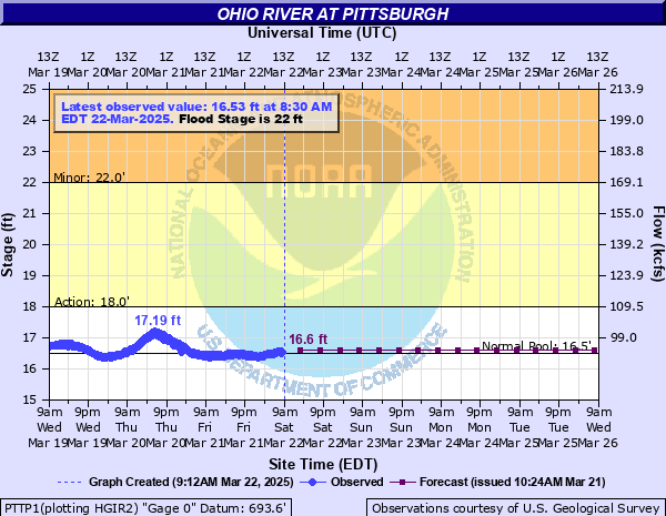
Updated: 10:45 AM EST 12/6/25
Status: No Flooding
Stage: 16.84 ft
Flow: 95.8 kcfs
Forecast
| Time | Stage (ft) | Flow (kcfs) |
|---|---|---|
| 1 PM 12/6 | 16.9 | 97 |
| 7 PM 12/6 | 16.9 | 97 |
| 1 AM 12/7 | 16.8 | 95 |
| 7 AM 12/7 | 16.8 | 95 |
| 1 PM 12/7 | 16.8 | 95 |
| 7 PM 12/7 | 16.8 | 95 |
| 1 AM 12/8 | 16.8 | 95 |
| 7 AM 12/8 | 16.8 | 95 |
| 1 PM 12/8 | 16.8 | 95 |
| 7 PM 12/8 | 16.8 | 95 |
| 1 AM 12/9 | 16.8 | 95 |
| 7 AM 12/9 | 16.8 | 95 |
| 1 PM 12/9 | 16.8 | 95 |
| 7 PM 12/9 | 16.8 | 95 |
| 1 AM 12/10 | 16.8 | 95 |
| 7 AM 12/10 | 16.8 | 95 |
| 1 PM 12/10 | 16.8 | 95 |
| 7 PM 12/10 | 16.8 | 95 |
| 1 AM 12/11 | 16.8 | 95 |
| 7 AM 12/11 | 16.8 | 95 |
| Time | Stage (ft) | Flow (kcfs) |
|---|---|---|
| 11:00 AM 12/6 | 16.84 | 95.8 |
| 10:55 AM 12/6 | 16.84 | 95.8 |
| 10:50 AM 12/6 | 16.85 | 96 |
| 10:45 AM 12/6 | 16.84 | 95.8 |
| 10:40 AM 12/6 | 16.86 | 96.2 |
| 10:35 AM 12/6 | 16.85 | 96 |
| 10:30 AM 12/6 | 16.86 | 96.2 |
| 10:25 AM 12/6 | 16.85 | 96 |
| 10:20 AM 12/6 | 16.85 | 96 |
| 10:15 AM 12/6 | 16.86 | 96.2 |
| 10:10 AM 12/6 | 16.86 | 96.2 |
| 10:05 AM 12/6 | 16.85 | 96 |
| 10:00 AM 12/6 | 16.87 | 96.4 |
| 9:55 AM 12/6 | 16.88 | 96.6 |
| 9:50 AM 12/6 | 16.88 | 96.6 |
| 9:45 AM 12/6 | 16.87 | 96.4 |
| 9:40 AM 12/6 | 16.87 | 96.4 |
| 9:35 AM 12/6 | 16.86 | 96.2 |
| 9:30 AM 12/6 | 16.9 | 97 |
| 9:25 AM 12/6 | 16.9 | 97 |
| 9:20 AM 12/6 | 16.95 | 98 |
| 9:15 AM 12/6 | 16.87 | 96.4 |
| 9:10 AM 12/6 | 16.88 | 96.6 |
| 9:05 AM 12/6 | 16.87 | 96.4 |
| 9:00 AM 12/6 | 16.88 | 96.6 |
| 8:55 AM 12/6 | 16.87 | 96.4 |
| 8:50 AM 12/6 | 16.85 | 96 |
| 8:45 AM 12/6 | 16.88 | 96.6 |
| 8:40 AM 12/6 | 16.91 | 97.2 |
| 8:35 AM 12/6 | 16.9 | 97 |
46' -
Severe damage occurs in Pittsburgh with up to 15 feet of water in the golden triangle. This is the level of the record flood in march of 1936.
40' -
PNC Park is flooded along Federal Street.
38' -
Water reaches the floor of Brunots Island Power Station.
37' -
Water reaches the floor level of Rivers Casino.
36.6' -
Steam distribution lines in Pittsburgh are in jeopardy. Water reaches the top of the flood wall at PNC park.
36' -
Serious flood damage occurs to about 500 businesses on the North Side and in downtown Pittsburgh. The Port Authority of Pittsburgh subway system is affected.
35.82' -
Flood waters reach the historic levels of Hurricane Agnes on June 26, 1972.
35' -
The river level reaches a critical stage for Acrisure Stadium and PNC Park.
32' -
Mckees Rocks is affected. Flooding occurs on Neville Island.
31' -
Water reaches the railroad tracks at Station Square on the South Side. PNC Park playing field is flooded. Flood waters reach the level of Hurricane Ivan on September 18, 2004.
30' -
200 manufacturing concerns and companies in Pittsburgh are affected by flooding. Acrisure Stadium playing field is flooded. Point state park is flooded to the Portal Bridge.
29' -
River Avenue on the North Side begins to flood.
28' -
Pumping operations begin on Neville Island. The Wood Street T station facilities are impacted. Fort Pitt Boulevard is closed.
27.6' -
The fountain in Point State Park is completely submerged.
26' -
State Correctional Institution Pittsburgh is impacted.
25' -
The Parkway Central (also known as the bathtub) is closed by flooding. Lower North Side businesses are affected.
24.9' -
Water enters the inner pool of the fountain.
24' -
Water enters the outer pool of the fountain.
22.5' -
The fountain plaza is flooded.
22' -
The Tenth Street Bypass floods.
20' -
Water is up to one foot deep in the lower areas of the North Shore Riverwalk.
19.5' -
The Monongahela Parking Wharf is completely flooded.
19' -
Water begins to flow onto the North Shore Riverwalk between the stadiums.
18' -
Water begins to flow onto the Monongahela Parking Wharf.
| Date | Stage (ft) |
|---|---|
| Mar 18, 1936 | 46 |
| Mar 15, 1907 | 38.5 |
| Dec 31, 1942 | 36.6 |
| Jun 24, 1972 | 35.82 |
| Mar 1, 1902 | 35.4 |
| Apr 27, 1937 | 35.1 |
| Jan 20, 1996 | 34.6 |
| Jan 26, 1937 | 34.5 |
| Jan 9, 1913 | 34.3 |
| Mar 7, 1945 | 33.4 |
| Jan 23, 1937 | 32.9 |
| Oct 16, 1954 | 32.4 |
| Mar 11, 1964 | 31.6 |
| Sep 18, 2004 | 31 |
| Mar 26, 1936 | 30.6 |
| Apr 15, 1948 | 29.8 |
| Jan 28, 1952 | 29.7 |
| Jan 22, 1959 | 29.23 |
| Feb 28, 1936 | 29.2 |
| Feb 14, 1966 | 28.6 |
Data provided by the National Weather Service.