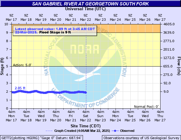
San Gabriel River at Georgetown South Fork
Critical Stages
5' - Action
9' - Flood
13' - Moderate
26' - Major
Latest Observation
Updated: 4:15 AM CST 12/10/25
Status: No Flooding
Stage: 1.61 ft
Flow: 0.0083 kcfs
Forecast
Forecast not available for this location.
| Time | Stage (ft) | Flow (kcfs) |
|---|---|---|
| 4:15 AM 12/10 | 1.61 | 0.0083 |
| 4:10 AM 12/10 | 1.61 | 0.0083 |
| 4:05 AM 12/10 | 1.61 | 0.0083 |
| 4:00 AM 12/10 | 1.61 | 0.0083 |
| 3:55 AM 12/10 | 1.61 | 0.0083 |
| 3:50 AM 12/10 | 1.61 | 0.0083 |
| 3:45 AM 12/10 | 1.61 | 0.0083 |
| 3:40 AM 12/10 | 1.61 | 0.0083 |
| 3:35 AM 12/10 | 1.61 | 0.0083 |
| 3:30 AM 12/10 | 1.61 | 0.0083 |
| 3:25 AM 12/10 | 1.61 | 0.0083 |
| 3:20 AM 12/10 | 1.61 | 0.0083 |
| 3:15 AM 12/10 | 1.61 | 0.0083 |
| 3:10 AM 12/10 | 1.6 | 0.008 |
| 3:05 AM 12/10 | 1.61 | 0.0083 |
| 3:00 AM 12/10 | 1.61 | 0.0083 |
| 2:55 AM 12/10 | 1.61 | 0.0083 |
| 2:50 AM 12/10 | 1.61 | 0.0083 |
| 2:45 AM 12/10 | 1.61 | 0.0083 |
| 2:40 AM 12/10 | 1.61 | 0.0083 |
| 2:35 AM 12/10 | 1.61 | 0.0083 |
| 2:30 AM 12/10 | 1.61 | 0.0083 |
| 2:25 AM 12/10 | 1.61 | 0.0083 |
| 2:20 AM 12/10 | 1.61 | 0.0083 |
| 2:15 AM 12/10 | 1.61 | 0.0083 |
| 2:10 AM 12/10 | 1.61 | 0.0083 |
| 2:05 AM 12/10 | 1.61 | 0.0083 |
| 2:00 AM 12/10 | 1.61 | 0.0083 |
| 1:55 AM 12/10 | 1.61 | 0.0083 |
| 1:50 AM 12/10 | 1.61 | 0.0083 |
26' -
Major lowland flooding closes many streets and roads. Much of the city park downstream floods. Lowest homes above Georgetown to Granger Lake are threatened.
23' -
Moderate lowland flooding inundates many secondary and primary roads near the San Gabriel River. Facilities and equipment well into the flood plain are flooded. Residents of lowest homes in the flood plain above Georgetown to Granger Lake should monitor NOAA Weather Radio for developing heavy rain and flood conditions.
20' -
Moderate lowland flooding closes secondary and primary roads near the river. The city park is severely flooded. Livestock and equipment should be moved from the flood plain from the headwaters to Granger Lake.
17' -
Moderate lowland flooding inundates many secondary and primary roads near the San Gabriel River from the headwaters of the South Fork to Granger Lake. The city park in Georgetown and any facilities and equipment in the flood plain are damaged.
13' -
Moderate lowland flooding inundates secondary roads and low bridges. Flow enters the lowest areas of the city park.
9' -
Minor lowland flooding reaches low areas of the flood plain with no significant damage. Lowest areas of the city park downtown are flooded.
5' -
Flow exceeds lowest sections of the banks.
| Date | Stage (ft) |
|---|---|
| Apr 24, 1956 | 41 |
| Jul 5, 2025 | 37.36 |
| Jun 27, 2007 | 31.65 |
| Nov 15, 2001 | 27.06 |
| Sep 3, 1981 | 24.6 |
| Sep 22, 2018 | 23.93 |
| Sep 8, 2010 | 21.98 |
| Feb 3, 1986 | 19.94 |
| May 24, 2015 | 17.12 |
| Oct 17, 1998 | 16.65 |
| May 26, 2015 | 15.75 |
| Nov 17, 2004 | 15.53 |
| Jun 9, 1997 | 12.28 |
| Oct 31, 2015 | 11.26 |
| May 8, 2019 | 9.29 |
| May 7, 2025 | 6.78 |
Data provided by the National Weather Service.