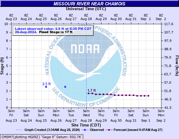
Missouri River near Chamois
Critical Stages
15' - Action
17' - Flood
28' - Moderate
31' - Major
Latest Observation
Updated: 6:09 PM LMT 12/31/00
Status: Obs Not Current
Stage: -999 ft
Flow: -999 kcfs
Forecast
| Time | Stage (ft) | Flow (kcfs) |
|---|---|---|
| 12 AM 12/16 | -1.9 | -999 |
| 6 AM 12/16 | -1.8 | -999 |
| 12 PM 12/16 | -1.7 | -999 |
| 6 PM 12/16 | -1.6 | -999 |
| 12 AM 12/17 | -1.5 | -999 |
| 6 AM 12/17 | -1.4 | -999 |
| 12 PM 12/17 | -1.3 | -999 |
| 6 PM 12/17 | -1.3 | -999 |
| 12 AM 12/18 | -1.2 | -999 |
| 6 AM 12/18 | -1.3 | -999 |
| 12 PM 12/18 | -1.3 | -999 |
| 6 PM 12/18 | -1.4 | -999 |
| 12 AM 12/19 | -1.4 | -999 |
| 6 AM 12/19 | -1.5 | -999 |
| 12 PM 12/19 | -1.5 | -999 |
| 6 PM 12/19 | -1.6 | -999 |
| 12 AM 12/20 | -1.7 | -999 |
| 6 AM 12/20 | -1.7 | -999 |
Observation history not available.
35.3' -
The Chamois sewage treatment pond levee is overtopped at this height.
34.4' -
The main floor of the Chamois Community Center begins to flood near this height. Near this height, a barn and farmhouse along City Park Road also begin to flood.
32.3' -
At this height, a farmhouse along City Park Road begins flooding.
31.3' -
Near this height, backwater along Dooling Creek will begin flooding homes, garages, and sheds along Main Street north of Hwy 100.
30.8' -
At this height, the outfield of the Chamois city park ballfield and a utility shed near the left field fence begins flooding.
30.6' -
The gazebo at the Chamois city park begins flooding near this height.
30.4' -
Near this height, Route Z west of Morrison will be closed in both directions.
30.2' -
The playground area of the city park and covered 3rd base line bleachers begin to flood.
30' -
The Chamois city park begins to flood.
29.9' -
The utility road behind the outfield fence at Chamois city park begins flooding.
28.5' -
Highway 100 closed between Chamois and Morrison.
28' -
Homes along North Main Street just north of Highway 100 begin to flood. Highway 100 near the power plant begins to flood. The Mokane levee just east of Mokane overtops near this height.
27.3' -
Highway 100 near the old power plant site begins flooding.
27.2' -
Near this height, Missouri Route C at Missouri Highway 94 near Mokane will be closed in both directions.
27' -
The Mokane levee just east of Mokane will overtop near this height.
26.5' -
The Steedman levee northwest of Chamois is overtopped near this level.
26' -
Highway 100 between St. Aubert Creek and Chamois begins flooding due to creek backwater. Near this height, Missouri Highway 94 will be closed from Route PP to Bluffton. The Jacobs and Tebbetts East levees near Tebbetts are overtopped near this level.
25.7' -
The Chamois levee just west of Chamois is overtopped near this height.
25.6' -
Highway 100 just west of Chamois begins flooding near this level.
25.5' -
Levee A-1 just east of Chamois is overtopped near this level.
25.4' -
Highway 100 between Morrison and State Route Z begins flooding near this level.
25' -
Both sections of the Chamois levee system just upstream of Chamois are overtopped near this level.
24.3' -
Highway 94 near Portland begins flooding near this height.
24.2' -
The upstream campsite at the Chamois river access campgrounds begins flooding near this height.
17' -
Flood Stage: Lower lying bottom land begins to flood.
| Date | Stage (ft) |
|---|---|
| Jul 31, 1993 | 33.3 |
| Jun 7, 2019 | 29.6 |
| Apr 24, 1973 | 28.7 |
| May 4, 2017 | 28.3 |
| Dec 29, 2015 | 28 |
| Jun 2, 2013 | 27.92 |
| Sep 16, 2008 | 27.17 |
| May 18, 1990 | 26.7 |
| Feb 25, 1985 | 26.3 |
| Apr 13, 1994 | 26.3 |
| Jun 28, 1967 | 25.2 |
| May 3, 1983 | 25.1 |
| Jun 9, 2001 | 25 |
| Jun 18, 2015 | 24.8 |
| Jul 23, 1958 | 24.8 |
| May 3, 2019 | 24.7 |
| May 9, 1961 | 24.6 |
| May 14, 2002 | 24.5 |
| Mar 26, 1978 | 24.3 |
| May 17, 2010 | 24.2 |
Data provided by the National Weather Service.