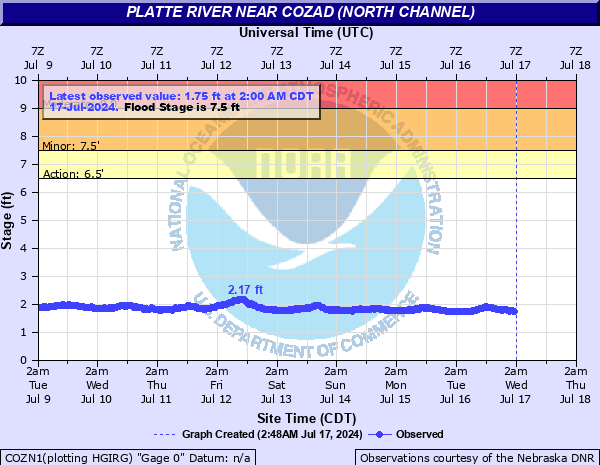
Platte River near Cozad (North Channel)
Critical Stages
6.5' - Action
7.5' - Flood
9' - Moderate
11' - Major
Latest Observation
Updated: 8:00 AM CST 12/16/25
Status: No Flooding
Stage: 2.61 ft
Flow: 0.104 kcfs
Forecast
Forecast not available for this location.
| Time | Stage (ft) | Flow (kcfs) |
|---|---|---|
| 8:00 AM 12/16 | 2.61 | 0.104 |
| 7:45 AM 12/16 | 2.61 | 0.104 |
| 7:30 AM 12/16 | 2.61 | 0.104 |
| 7:15 AM 12/16 | 2.61 | 0.104 |
| 7:00 AM 12/16 | 2.61 | 0.104 |
| 6:45 AM 12/16 | 2.61 | 0.104 |
| 6:30 AM 12/16 | 2.61 | 0.104 |
| 6:15 AM 12/16 | 2.62 | 0.105 |
| 6:00 AM 12/16 | 2.62 | 0.105 |
| 5:45 AM 12/16 | 2.62 | 0.105 |
| 5:30 AM 12/16 | 2.62 | 0.105 |
| 5:15 AM 12/16 | 2.63 | 0.107 |
| 5:00 AM 12/16 | 2.63 | 0.107 |
| 4:45 AM 12/16 | 2.63 | 0.107 |
| 4:30 AM 12/16 | 2.63 | 0.107 |
| 4:15 AM 12/16 | 2.64 | 0.109 |
| 4:00 AM 12/16 | 2.64 | 0.109 |
| 3:45 AM 12/16 | 2.64 | 0.109 |
| 3:30 AM 12/16 | 2.64 | 0.109 |
| 3:15 AM 12/16 | 2.65 | 0.11 |
| 3:00 AM 12/16 | 2.65 | 0.11 |
| 2:45 AM 12/16 | 2.65 | 0.11 |
| 2:30 AM 12/16 | 2.65 | 0.11 |
| 2:15 AM 12/16 | 2.66 | 0.112 |
| 2:00 AM 12/16 | 2.66 | 0.112 |
| 1:45 AM 12/16 | 2.66 | 0.112 |
| 1:30 AM 12/16 | 2.66 | 0.112 |
| 1:15 AM 12/16 | 2.66 | 0.112 |
| 1:00 AM 12/16 | 2.66 | 0.112 |
| 12:45 AM 12/16 | 2.66 | 0.112 |
11' -
Gravel pits and some rural homes and county roads adjacent to the river may begin to flood. The town of Cozad is not located in the flood plain.
9' -
Properties along the south channel begin to be impacted.
7.5' -
Minor lowland flooding occurs as both banks overflow.
7' -
Water will enter the Blue Heron campground upstream and south of Gothenburg.
Historical crest information is not available.
Data provided by the National Weather Service.