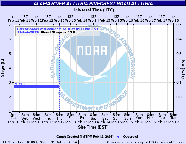
Alafia River at Lithia Pinecrest Road at Lithia
Critical Stages
11' - Action
13' - Flood
16' - Moderate
19' - Major
Latest Observation
Updated: 1:00 AM EST 12/11/25
Status: No Flooding
Stage: 3.39 ft
Flow: 0.111 kcfs
Forecast
Forecast not available for this location.
| Time | Stage (ft) | Flow (kcfs) |
|---|---|---|
| 1:00 AM 12/11 | 3.39 | 0.111 |
| 12:45 AM 12/11 | 3.39 | 0.111 |
| 12:30 AM 12/11 | 3.4 | 0.112 |
| 12:15 AM 12/11 | 3.4 | 0.112 |
| 12:00 AM 12/11 | 3.4 | 0.112 |
| 11:45 PM 12/10 | 3.4 | 0.112 |
| 11:30 PM 12/10 | 3.4 | 0.112 |
| 11:15 PM 12/10 | 3.4 | 0.112 |
| 11:00 PM 12/10 | 3.41 | 0.113 |
| 10:45 PM 12/10 | 3.41 | 0.113 |
| 10:30 PM 12/10 | 3.41 | 0.113 |
| 10:15 PM 12/10 | 3.42 | 0.114 |
| 10:00 PM 12/10 | 3.42 | 0.114 |
| 9:45 PM 12/10 | 3.42 | 0.114 |
| 9:30 PM 12/10 | 3.42 | 0.114 |
| 9:15 PM 12/10 | 3.43 | 0.115 |
| 9:00 PM 12/10 | 3.43 | 0.115 |
| 8:45 PM 12/10 | 3.43 | 0.115 |
| 8:30 PM 12/10 | 3.43 | 0.115 |
| 8:15 PM 12/10 | 3.44 | 0.116 |
| 8:00 PM 12/10 | 3.44 | 0.116 |
| 7:45 PM 12/10 | 3.44 | 0.116 |
| 7:30 PM 12/10 | 3.44 | 0.116 |
| 7:15 PM 12/10 | 3.45 | 0.117 |
| 7:00 PM 12/10 | 3.45 | 0.117 |
| 6:45 PM 12/10 | 3.45 | 0.117 |
| 6:30 PM 12/10 | 3.46 | 0.118 |
| 6:15 PM 12/10 | 3.46 | 0.118 |
| 6:00 PM 12/10 | 3.47 | 0.119 |
| 5:45 PM 12/10 | 3.47 | 0.119 |
29.5' -
Height of the County Road 640 roadbed.
27' -
Water covers County Road 640 Lithia area.
15' -
Additional residences downstream of County Road 640 bridge begin flooding.
13' -
River Drive and Squirrel Run Way downstream of County Road 640 are completely covered by water. One home begins to flood.
12' -
Water begins to affect River Drive and Squirrel Run Way downstream of County Road 640.
| Date | Stage (ft) |
|---|---|
| Sep 7, 1933 | 28.5 |
| Oct 11, 2024 | 24.36 |
| Sep 12, 1960 | 23.98 |
| Sep 20, 1947 | 23.24 |
| Jul 31, 1960 | 22.83 |
| Sep 12, 2017 | 22.79 |
| Sep 7, 2004 | 22.33 |
| Aug 29, 1949 | 22.14 |
| Sep 8, 1988 | 21.71 |
| Sep 5, 1935 | 20.52 |
| Aug 7, 2024 | 20.17 |
| Mar 18, 1960 | 20.06 |
| Mar 21, 1959 | 19.91 |
| Oct 17, 1938 | 19.71 |
| Jul 26, 1945 | 19.69 |
| Jun 25, 1945 | 19.62 |
| Jun 16, 1934 | 19.35 |
| Sep 28, 2004 | 19.19 |
| Oct 21, 1952 | 19.13 |
| Jan 2, 2003 | 19.1 |
Data provided by the National Weather Service.