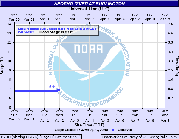
Neosho River at Burlington
Critical Stages
22' - Action
27' - Flood
40' - Moderate
45' - Major
Latest Observation
Updated: 7:15 PM CST 12/15/25
Status: No Flooding
Stage: 6.94 ft
Flow: 0.435 kcfs
Forecast
Forecast not available for this location.
| Time | Stage (ft) | Flow (kcfs) |
|---|---|---|
| 8:30 PM 12/15 | 6.92 | 0.426 |
| 8:15 PM 12/15 | 6.93 | 0.43 |
| 8:00 PM 12/15 | 6.93 | 0.43 |
| 7:45 PM 12/15 | 6.93 | 0.43 |
| 7:30 PM 12/15 | 6.93 | 0.43 |
| 7:15 PM 12/15 | 6.94 | 0.435 |
| 7:00 PM 12/15 | 6.95 | 0.44 |
| 6:45 PM 12/15 | 6.96 | 0.444 |
| 6:30 PM 12/15 | 6.97 | 0.449 |
| 6:15 PM 12/15 | 6.98 | 0.454 |
| 6:00 PM 12/15 | 6.99 | 0.459 |
| 5:45 PM 12/15 | 7.01 | 0.469 |
| 5:30 PM 12/15 | 7.03 | 0.479 |
| 5:15 PM 12/15 | 7.05 | 0.489 |
| 5:00 PM 12/15 | 7.07 | 0.5 |
| 4:45 PM 12/15 | 7.1 | 0.516 |
| 4:30 PM 12/15 | 7.14 | 0.534 |
| 4:15 PM 12/15 | 7.19 | 0.557 |
| 4:00 PM 12/15 | 7.24 | 0.582 |
| 3:45 PM 12/15 | 7.3 | 0.612 |
| 3:30 PM 12/15 | 7.37 | 0.649 |
| 3:15 PM 12/15 | 7.45 | 0.693 |
| 3:00 PM 12/15 | 7.55 | 0.752 |
| 2:45 PM 12/15 | 7.65 | 0.816 |
| 2:30 PM 12/15 | 7.77 | 0.898 |
| 2:15 PM 12/15 | 7.88 | 0.978 |
| 2:00 PM 12/15 | 8.02 | 1.09 |
| 1:45 PM 12/15 | 8.11 | 1.16 |
| 1:30 PM 12/15 | 8.12 | 1.16 |
| 1:15 PM 12/15 | 8.12 | 1.16 |
41.5' -
Overflow is very widespread and can reach a width of 2 miles.
40.2' -
Flood waters reach top of bridge deck.
27' -
The left, or east, bank of the river floods.
| Date | Stage (ft) |
|---|---|
| Jul 12, 1951 | 41.53 |
| Jul 21, 1948 | 36.8 |
| Apr 17, 1945 | 35.1 |
| Apr 24, 1944 | 35 |
| Jul 2, 1951 | 34.5 |
| Dec 6, 1944 | 34.3 |
| May 26, 2019 | 32.73 |
| May 3, 1951 | 32.4 |
| Sep 7, 1951 | 32.3 |
| Apr 13, 1944 | 32 |
| Sep 13, 1961 | 31.53 |
| Sep 28, 1962 | 31.36 |
| Oct 3, 1945 | 31 |
| Aug 4, 2008 | 30.7 |
| Apr 11, 1944 | 30.7 |
| Apr 13, 1947 | 30.35 |
| May 18, 1957 | 30.3 |
| Apr 16, 1947 | 30.25 |
| Jun 1, 1962 | 30 |
| Nov 6, 1998 | 29.84 |
Data provided by the National Weather Service.