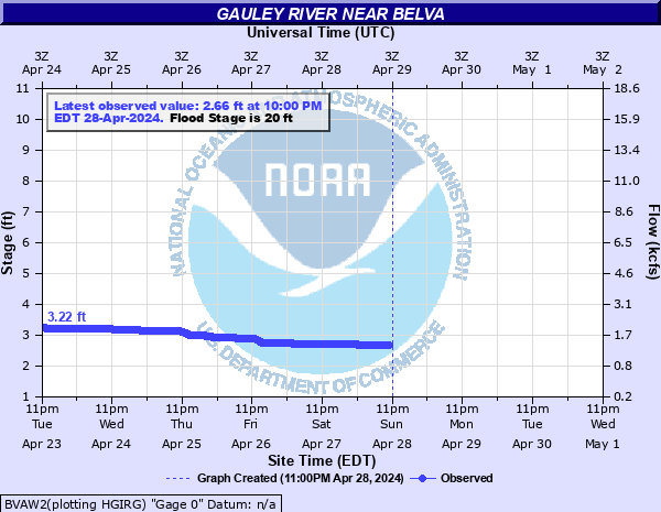
Gauley River near Belva
Critical Stages
18' - Action
20' - Flood
24' - Moderate
27' - Major
Latest Observation
Updated: 2:00 AM EST 12/5/25
Status: No Flooding
Stage: 3.52 ft
Flow: 2.11 kcfs
Forecast
Forecast not available for this location.
| Time | Stage (ft) | Flow (kcfs) |
|---|---|---|
| 2:00 AM 12/5 | 3.52 | 2.11 |
| 1:45 AM 12/5 | 3.52 | 2.11 |
| 1:30 AM 12/5 | 3.53 | 2.12 |
| 1:15 AM 12/5 | 3.54 | 2.14 |
| 1:00 AM 12/5 | 3.55 | 2.15 |
| 12:45 AM 12/5 | 3.56 | 2.16 |
| 12:30 AM 12/5 | 3.57 | 2.17 |
| 12:15 AM 12/5 | 3.58 | 2.19 |
| 12:00 AM 12/5 | 3.59 | 2.2 |
| 11:45 PM 12/4 | 3.61 | 2.23 |
| 11:30 PM 12/4 | 3.62 | 2.24 |
| 11:15 PM 12/4 | 3.63 | 2.25 |
| 11:00 PM 12/4 | 3.64 | 2.27 |
| 10:45 PM 12/4 | 3.64 | 2.27 |
| 10:30 PM 12/4 | 3.64 | 2.27 |
| 10:15 PM 12/4 | 3.64 | 2.27 |
| 10:00 PM 12/4 | 3.64 | 2.27 |
| 9:45 PM 12/4 | 3.64 | 2.27 |
| 9:30 PM 12/4 | 3.64 | 2.27 |
| 9:15 PM 12/4 | 3.64 | 2.27 |
| 9:00 PM 12/4 | 3.64 | 2.27 |
| 8:45 PM 12/4 | 3.64 | 2.27 |
| 8:30 PM 12/4 | 3.64 | 2.27 |
| 8:15 PM 12/4 | 3.65 | 2.28 |
| 8:00 PM 12/4 | 3.65 | 2.28 |
| 7:45 PM 12/4 | 3.65 | 2.28 |
| 7:30 PM 12/4 | 3.65 | 2.28 |
| 7:15 PM 12/4 | 3.65 | 2.28 |
| 7:00 PM 12/4 | 3.65 | 2.28 |
| 6:45 PM 12/4 | 3.65 | 2.28 |
30' -
Almost all of Belva is flooded.
27' -
Railroad tracks, Route 39, businesses, and homes are flooded in Belva.
24' -
Between 24 and 25 feet, the homes along the river in Belva start to flood.
22' -
The welding shop and home next to it start to flood.
20' -
Low sections of Highway 39 above and below the Town of Belva start to flood.
| Date | Stage (ft) |
|---|---|
| Jul 5, 1932 | 28.6 |
| Jun 27, 1940 | 26.35 |
| Jul 19, 1954 | 24.8 |
| Mar 5, 1955 | 22.99 |
| Oct 28, 1938 | 21.37 |
| Jan 7, 1946 | 21 |
| Feb 14, 1948 | 20.62 |
| Jan 29, 1957 | 20.02 |
| Nov 19, 2003 | 19.23 |
| Jul 29, 2001 | 19.09 |
| Jul 2, 1986 | 17.9 |
| Feb 26, 1972 | 16.86 |
| Jun 2, 1974 | 15.69 |
| Jan 19, 1996 | 15.21 |
| Apr 24, 1987 | 14.51 |
| Mar 20, 1975 | 13.99 |
Data provided by the National Weather Service.