« Back to Still Waters Resort Rivers
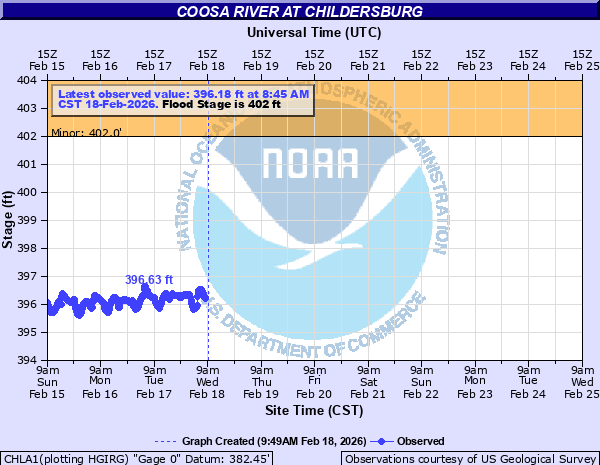
Coosa River at Childersburg
Critical Stages
402' - Action
402' - Flood
407' - Moderate
410' - Major
Latest Observation
Updated: 7:45 AM CST 12/6/25
Status: No Flooding
Stage: 396.06 ft
Flow: -999 kcfs
Forecast
Forecast not available for this location.
| Time | Stage (ft) | Flow (kcfs) |
|---|---|---|
| 7:45 AM 12/6 | 396.06 | -999 |
| 7:30 AM 12/6 | 396.04 | -999 |
| 7:15 AM 12/6 | 396.04 | -999 |
| 7:00 AM 12/6 | 396.05 | -999 |
| 6:45 AM 12/6 | 396.08 | -999 |
| 6:30 AM 12/6 | 396.1 | -999 |
| 6:15 AM 12/6 | 396.12 | -999 |
| 6:00 AM 12/6 | 396.12 | -999 |
| 5:45 AM 12/6 | 396.16 | -999 |
| 5:30 AM 12/6 | 396.19 | -999 |
| 5:15 AM 12/6 | 396.23 | -999 |
| 5:00 AM 12/6 | 396.28 | -999 |
| 4:45 AM 12/6 | 396.31 | -999 |
| 4:30 AM 12/6 | 396.33 | -999 |
| 4:15 AM 12/6 | 396.32 | -999 |
| 4:00 AM 12/6 | 396.33 | -999 |
| 3:45 AM 12/6 | 396.3 | -999 |
| 3:30 AM 12/6 | 396.3 | -999 |
| 3:15 AM 12/6 | 396.26 | -999 |
| 3:00 AM 12/6 | 396.24 | -999 |
| 2:45 AM 12/6 | 396.2 | -999 |
| 2:30 AM 12/6 | 396.12 | -999 |
| 2:15 AM 12/6 | 396.05 | -999 |
| 2:00 AM 12/6 | 395.98 | -999 |
| 1:45 AM 12/6 | 395.92 | -999 |
| 1:30 AM 12/6 | 395.89 | -999 |
| 1:15 AM 12/6 | 395.89 | -999 |
| 1:00 AM 12/6 | 395.88 | -999 |
| 12:45 AM 12/6 | 395.88 | -999 |
| 12:30 AM 12/6 | 395.89 | -999 |
415' -
Exceptional flooding in the Chancellor Ferry area. Flood waters reach homes north of Cosper Bend and reach the edge of State Route 76 with flooding possible north of 76 in farmland areas of Deer Lick Branch. Areas along Talladega Creek from the Skeet Club to baseball field see extensive flooding.
412' -
Widespread residential flooding occurs...and evacuations are needed.
410' -
Several homes and steets along Edgewood Drive, Woodside Street and Canal Street begin to flood. Flooding along 4th Ave Northeast begins as backwater develops from Tallaseehatchee Creek. Water approaches a few houses along River Run Road and River Run Circle. Water covers sections of Chancellor Ferry Cove with several homes affected. Watercross Drive is flooded with several homes in the area of State Route 76 and Cosper Bend at risk. The west side of River Run Rd is flooded along with some homes.
407' -
Houses at Woodside Street become susceptible to flooding.
405' -
Yards begin to flood along sections of Woodside Street, Canal Street, River Run Circle and River Run Road. Several yards near State Route 76 (Klein Road) and Watercross Drive and Chancellor Ferry Cove flood. Extensive flooding of farm and foreast land from Prince Island to Cosper Bend flood.
404' -
Water begins to approach or cover a few low lying roads. Yards of a few homes near the river begin to flood. Areas along Edgewood Drive are particularly vulnerable. Farmland between 4th Ave Northeast and State Route 76 in Childersburg begins to flood.
402' -
Flooding of low lying areas begins.
| Date | Stage (ft) |
|---|---|
| Feb 23, 1961 | 412.86 |
| Mar 30, 1951 | 412.55 |
| Apr 9, 1938 | 412.48 |
| Apr 14, 1979 | 411.44 |
| Feb 5, 1936 | 410.95 |
| Nov 30, 1948 | 410.75 |
| Jan 21, 1947 | 409.4 |
| May 9, 2003 | 407.41 |
| Mar 17, 1990 | 407.07 |
| Dec 19, 1962 | 405.62 |
| Dec 26, 2015 | 405.49 |
| Mar 21, 1980 | 405.37 |
| Feb 3, 1996 | 404.91 |
| Dec 6, 1983 | 404.27 |
| Jun 22, 1989 | 403.98 |
| Mar 11, 2010 | 403.8 |
| Mar 11, 2011 | 403.8 |
| Mar 8, 1996 | 403.77 |
| May 21, 1983 | 403.72 |
| Mar 22, 1942 | 403.65 |
Data provided by the National Weather Service.