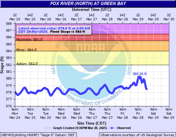
Fox River (North) at Green Bay
Critical Stages
582' - Action
584' - Flood
585.5' - Moderate
586.5' - Major
Latest Observation
Updated: 7:00 AM CST 12/5/25
Status: No Flooding
Stage: 577.56 ft
Flow: 9.65 kcfs
Forecast
Forecast not available for this location.
| Time | Stage (ft) | Flow (kcfs) |
|---|---|---|
| 7:00 AM 12/5 | 577.56 | 9.65 |
| 6:55 AM 12/5 | 577.55 | 9.6 |
| 6:50 AM 12/5 | 577.54 | 9.55 |
| 6:45 AM 12/5 | 577.52 | 9.45 |
| 6:40 AM 12/5 | 577.5 | 9.35 |
| 6:35 AM 12/5 | 577.48 | 9.24 |
| 6:30 AM 12/5 | 577.45 | 9.1 |
| 6:25 AM 12/5 | 577.43 | 9 |
| 6:20 AM 12/5 | 577.4 | 8.85 |
| 6:15 AM 12/5 | 577.36 | 8.66 |
| 6:10 AM 12/5 | 577.34 | 8.57 |
| 6:05 AM 12/5 | 577.3 | 8.39 |
| 6:00 AM 12/5 | 577.26 | 8.21 |
| 5:55 AM 12/5 | 577.22 | 8.03 |
| 5:50 AM 12/5 | 577.17 | 7.82 |
| 5:45 AM 12/5 | 577.13 | 7.65 |
| 5:40 AM 12/5 | 577.09 | 7.49 |
| 5:35 AM 12/5 | 577.04 | 7.29 |
| 5:30 AM 12/5 | 576.99 | 7.09 |
| 5:25 AM 12/5 | 576.94 | 6.9 |
| 5:20 AM 12/5 | 576.9 | 6.75 |
| 5:15 AM 12/5 | 576.85 | 6.57 |
| 5:10 AM 12/5 | 576.8 | 6.4 |
| 5:05 AM 12/5 | 576.76 | 6.26 |
| 5:00 AM 12/5 | 576.72 | 6.13 |
| 4:55 AM 12/5 | 576.68 | 6 |
| 4:50 AM 12/5 | 576.64 | 5.87 |
| 4:45 AM 12/5 | 576.6 | 5.74 |
| 4:40 AM 12/5 | 576.56 | 5.62 |
| 4:35 AM 12/5 | 576.53 | 5.53 |
586' -
Major flooding occurring in downtown Green Bay along the Fox River and along the East River, Baird Creek and tributaries.
585.5' -
Waters approach portions of Quincy street on the east side of the river. Major flooding is likely occurring upstream along the East River and Baird Creek.
585' -
Widespread lowland flooding is occurring on the east side of Green Bay between the river and Quincy street. Moderate flooding is likely occurring upstream adjacent to the East River and Baird Creek.
584.5' -
Lowland flooding is occurring along the east side of the Fox River from the East River outlet to the Bay of Green Bay. Widespread lowland flooding is also likely occurring along the East River in east Green Bay and Allouez.
584' -
Water begins to flood a yacht club and landing area near the mouth of the river. Flooding affects are also likely occurring on the East River on the east side of Green Bay.
582' -
There is minor lowland flooding.
| Date | Stage (ft) |
|---|---|
| Apr 13, 1952 | 585.2 |
| Jul 25, 2019 | 585.12 |
| Apr 1, 1972 | 584.79 |
| Mar 15, 1929 | 584.7 |
| Mar 8, 1973 | 584.7 |
| Apr 29, 2020 | 584.4 |
| Dec 1, 2019 | 584.14 |
| Jun 23, 2020 | 584.14 |
| May 19, 2020 | 583.99 |
| Oct 2, 2019 | 583.66 |
| Jun 23, 1990 | 583.5 |
| Sep 12, 2022 | 582.3 |
| Apr 4, 2023 | 581.12 |
| Apr 27, 2011 | 580.75 |
| Apr 14, 2014 | 580.5 |
Data provided by the National Weather Service.