Menominee River at Koss
Critical Stages
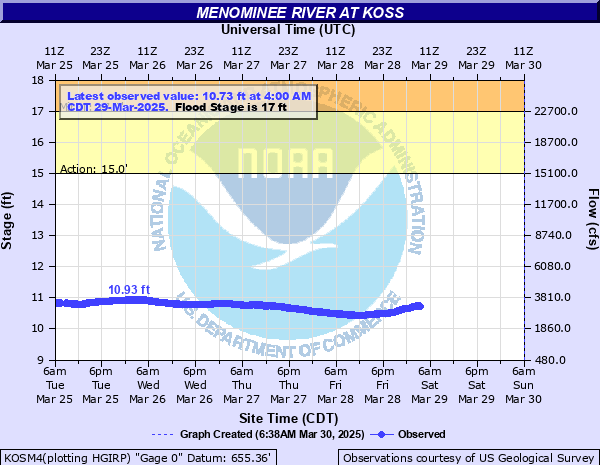
15' - Action
17' - Flood
19' - Moderate
21' - Major
Latest Observation
Updated: 7:00 AM CST 12/5/25
Status: No Flooding
Stage: 10.1 ft
Flow: 2.04 kcfs
Forecast
Forecast not available for this location.
| Time | Stage (ft) | Flow (kcfs) |
|---|---|---|
| 7:00 AM 12/5 | 10.1 | 2.04 |
| 6:54 AM 12/5 | 10.1 | 2.04 |
| 6:48 AM 12/5 | 10.1 | 2.04 |
| 6:42 AM 12/5 | 10.1 | 2.04 |
| 6:36 AM 12/5 | 10.11 | 2.05 |
| 6:30 AM 12/5 | 10.11 | 2.05 |
| 6:24 AM 12/5 | 10.11 | 2.05 |
| 6:18 AM 12/5 | 10.11 | 2.05 |
| 6:12 AM 12/5 | 10.11 | 2.05 |
| 6:06 AM 12/5 | 10.11 | 2.05 |
| 6:00 AM 12/5 | 10.11 | 2.05 |
| 5:54 AM 12/5 | 10.11 | 2.05 |
| 5:48 AM 12/5 | 10.11 | 2.05 |
| 5:42 AM 12/5 | 10.11 | 2.05 |
| 5:36 AM 12/5 | 10.12 | 2.07 |
| 5:30 AM 12/5 | 10.12 | 2.07 |
| 5:24 AM 12/5 | 10.12 | 2.07 |
| 5:18 AM 12/5 | 10.12 | 2.07 |
| 5:12 AM 12/5 | 10.13 | 2.09 |
| 5:06 AM 12/5 | 10.12 | 2.07 |
| 5:00 AM 12/5 | 10.13 | 2.09 |
| 4:54 AM 12/5 | 10.13 | 2.09 |
| 4:48 AM 12/5 | 10.13 | 2.09 |
| 4:42 AM 12/5 | 10.13 | 2.09 |
| 4:36 AM 12/5 | 10.13 | 2.09 |
| 4:30 AM 12/5 | 10.13 | 2.09 |
| 4:24 AM 12/5 | 10.13 | 2.09 |
| 4:18 AM 12/5 | 10.13 | 2.09 |
| 4:12 AM 12/5 | 10.13 | 2.09 |
| 4:06 AM 12/5 | 10.13 | 2.09 |
21' -
Several feet of water is surrounding several homes and cottages in the area along the river.
20' -
Several feet of water is surrounding a home on the Wisconsin side of the river.
18' -
Floodwaters approach a home on the Wisconsin side of the river.
17' -
Water floods a boat landing near the gauge.
15' -
There is minor flooding to wooded lowland.
| Date | Stage (ft) |
|---|---|
| May 10, 1960 | 19.6 |
| May 12, 1965 | 18.3 |
| Apr 27, 1979 | 17.5 |
| Apr 18, 2023 | 17.46 |
| Apr 23, 1916 | 17.3 |
| Apr 20, 2002 | 17.23 |
| Apr 26, 2019 | 16.38 |
| Apr 23, 2004 | 15.56 |
| Apr 16, 2022 | 15.3 |
| Apr 4, 2013 | 15.29 |
| Apr 6, 2020 | 14.94 |
| May 29, 2015 | 14.5 |
| Mar 13, 2021 | 13.85 |
Data provided by the National Weather Service.